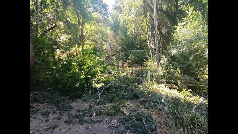
Stevens Canyon Trail: Tree/Power Lines Down
At the end of July, just as I got to the gate at the end of the paved road, a strange sound came down the power lines overhead. It sounded like the noise you hear in a rail way ahead of a far off train, or like a supersonic projectile whizzing by. You could see waves running down the lines and reflecting back from each power pole.
I thought a branch may have fallen on the lines up ahead and I did see one decent size branch hanging off the wires. Then I got to the steel bridge and saw what really happened. Wires on the ground after an enormous tree had fallen down from above and across the road and power/phone lines.
Since there's nothing up the canyon past here, I had assumed the lines had been disconnected when the last cabins were demolished about 8 years ago. But then a local resident came up to see why his power was out, so then I knew these lines were still live.
I decided not to push my luck this day and turned around and headed back home. Still ended up with about a 32 mile ride. Tree fell on 24 July and I suspect the crew I passed as I rode down the canyon had it cleared that day.
Why PG&E hasn't abandoned these lines is beyond me. These are the sort of lines that can cause fires when trees like this fall on them, as has happened many times in previous years. Then they actually sent a crew up to repair the lines! I guess it must cost money to disconnect a power line. You need to add disconnecting hardware to the end pole or additional bracing for that end pole since it'll be supporting the tension of the lines running up to it.
Then you still have this crazy policy of just pushing all the fallen wood off to the side of the trail, where it piles up year after year and adds to the fuel load if a fire ever starts. I guess it costs money to haul the dead wood away. Plus there are regulations relating to "sudden oak death" that makes hauling wood out of this area akin to hauling radioactive waste as far as the permits and logistics involved. And the main cause of sudden oak death is trees being to crowded together encourages the fungal spores to spread between trees via direct contact. Thin out the woods, like the indigenous Ohlone people did in pre-contact days and viola, problem solved.
36
views
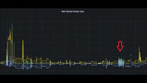
AC Diversion Load: Damping Function
Adding a "damping" feature to the AC diversion load program code to help damp out oscillations in the settings that seem to occur from time to time.
The basic idea is to keep the ability for the diversion load to increase immediately when the AC load in the house decreases, but have it ramp down gradually when the AC load in the house increases. This is done by taking the average of the old and new dimmer setting when a decrease is detected. Thus, the change in diversion load may be spread out over 1 - 1.5 minutes, which is 4 - 6 power sampling intervals. This should help to filter out startup power surges and other short duration spikes in load, like the oven cycling on and off.
More to come...
Subscribe for more content like this
Comment, like, share & click the bell icon
And as always, thanks for watching
Intro/Outro:
Louisiana Fairytale by Austin Rogers
https://web.archive.org/web/20170402222425/http://drfiddle.com/show_tune.php?id=94
1
view
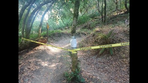
Table Mountain Trail Closure - July 2022 - April 2023
PSA for folks planning to hike/bike/ride on the Table Mountain Trail in Upper Stevens Creek County Park: it's closed until April 2023.
This is a somewhat confusing trail. Per the signs, at the creek crossing, this trail is signed "Lower Table Mountain Trail", it's designated uphill-only for bicycles. Up on top of Table Mountain, just passed where it meets Charcoal Road, the trail is signed "Table Mountain Trail". That trail is hiking only, no bicycles. Charcoal Road is designated uphill-only for bicycles. The official map of the area only has the entire trail named "Table Mountain Trail".
County Park Trail Closure info:
https://parks.sccgov.org/closures-updates
"Beginning Tuesday, July 19, Table Mountain Trail will be closed until April 2023 for repair. The trail will be unsafe for the public once the work begins. Charcoal Road will remain open, but visitors will not be able to connect through to the Canyon Trail on the Table Mountain Trail."
More to come...
Subscribe for more content like this
Comment, like, share & click the bell icon
And as always, thanks for watching
12
views

New Spatula Handle
Making a new handle for an old Nylon spatula
I used a short length of 1" wooden dowel, cut to the length of the old plastic handle along with a short cutoff length of copper water pipe to use as a ferrule. Turn down the end of the dowel and then press on the ferrule, which was a bit over 0.8". I dipped the end of the handle in some spar varnish first to provide some moisture protection. Then the handle was tapered down to the ferrule and the end rounded over. After sanding, it was dipped in spar varnish and hung to dry for a day.
I've made a number of handles like this over the years. Usually a spur of the moment project, no plans, and always done using materials at hand. Most often, I'll use a piece of a branch pruned off a tree.
More to come...
Subscribe for more content like this
Comment, like, share & click the bell icon
And as always, thanks for watching
Intro/Outro:
Louisiana Fairytale by Austin Rogers
https://web.archive.org/web/20170402222425/http://drfiddle.com/show_tune.php?id=94
20
views
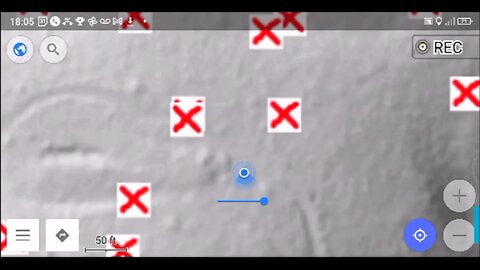
Grizzly Flat Trail, North/South Trail Junction, Closer Look Pt. 2
A return visit to the middle junction of the Grizzly Flat North and South trails. There's a short spur called the Grizzly Flat Cutoff Trail that joins the 2 trails here. Had more time to spend exploring this area and testing out the DIY hill shade map.
This is the only large, relatively flat area on this entire ridge. There's a large steel tank here. I found no signs of fence or pipe on the south end of the clearing.
Looks like I've finally dialed in the DIY hill shade map calibration. So nice to be able to navigate to a feature on the map, then look around and find the feature on the ground. Some of these features are invisible at first glance, but knowing there's something there, you move a bit, look from a different angle and there it is!
Followed several traces on the map to find signs of faint trails that may need further exploration. The one to the SW might lead to a water source as it seems to head uphill a ways. Then there's a trail running NE down the crest of the ridge.
What do you think this area was used for?
About the USGS hill shade maps:
https://apps.nationalmap.gov/viewer/
Subscribe for more content like this
Comment, rate, share & click the bell icon
And as always, thanks for watching
#USGS #HillShade
1
view
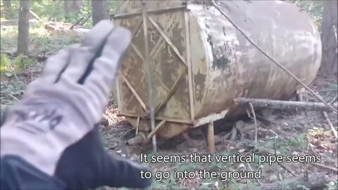
Grizzly Flat Trail, North/South Trail Junction, Closer Look
A return visit to the middle junction of the Grizzly Flat North and South trails. There's a short spur called the Grizzly Flat Cutoff Trail that joins the 2 trails here. Had more time this visit to spend exploring this area.
This is the only large, relatively flat area on this entire ridge. There's a large steel tank here, upon closer inspection, it appears to be around 5000 gallons. I wonder if that vertical pipe runs underground to a water source? Would need to use a metal detector to try and trace where it goes.
Looks like I've finally dialed in the DIY hill shade map calibration. Found the 2 "humps" or piles of dirt at the east end of this area along with the large ditch in the middle. This area has been leveled and a fair amount of earth moved both for that as well as the ditch.
What do you think this area was used for?
About the USGS hill shade maps:
https://apps.nationalmap.gov/viewer/
More to come, exploring off the the north east looking for signs of pipe and fencing and what looks like a faint trail...
Subscribe for more content like this
Comment, rate, share & click the bell icon
And as always, thanks for watching
#USGS #HillShade
5
views

Ensupra Electricity Usage Monitor: Battery Change
Replacing the memory backup battery in an Ensupra electrical power meter.
I think my battery has been dead for many years as I never recall that it had an memory feature. I'll see how this one works and if it starts to fail, maybe there's something wrong with the charging circuit.
Symptoms of a bad backup battery:
1. Loss of readings during power outage
2. Unstable voltage reading
3. No power reading
4. Loss of display
@Lawrence Francis: Kuman power meter repair - NiMH battery replacement
https://youtu.be/JRNuHORo3bE
Tear down video for a 220V/UK version:
https://youtu.be/aAGSXiZKfIE
Link for battery, 3.6V, 20mAH NiMH:
https://www.ebay.com/itm/233878211171
More to come...
Subscribe for more content like this
Comment, rate, share & click the bell icon
And as always, thanks for watching
Intro/Outro:
Louisiana Fairytale by Austin Rogers
https://web.archive.org/web/20170402222425/http://drfiddle.com/show_tune.php?id=94
10
views

Grizzly Flat Trail, North/South Trail Junction
A short stop on a bike ride up the Grizzly Flat / North Trail in Upper Stevens Creek County Park. This area is at the location of the middle junction of the north and south trails. There's a short spur called the Grizzly Flat Cutoff Trail that joins the 2 trails here.
This is the only large, relatively flat area on this entire ridge. There's a large steel tank here, upon closer inspection, it appears to be around 6000 gallons. My DIY hill shade map is still off a bit, so will be trying to fix that before the next visit.
What do you think this area was used for?
About the USGS hill shade maps:
https://apps.nationalmap.gov/viewer/
More to come...
Subscribe for more content like this
Comment, rate, share & click the bell icon
And as always, thanks for watching
#USGS #HillShade
5
views
Trail Along Waterwheel Creek
Just like the creek, you won't find this trail on any map either.
This trail is brutally steep, many sections above 50% gradient. Up to the grove of trees I stopped at, I traveled 2100 ft. and gained 700 ft. of elevation or 33% average gradient. It looks to be another 0.25 mile and 300 ft. of climbing to get to the official Waterwheel Creek Trail. If you did this same trip down the Canyon trail, Stevens Creek and Montebello Roads, you're looking at close to 10 miles. Or you could go up the Canyon Trail, then up the Indian Creek Trail and back down Montebello Road which is around 5 miles. So this faint user trail makes an interesting way to efficiently access this area.
Interesting point, after using historic topo maps and the new LIDAR based hillshade maps to find old roads and trails, this one was found using good old fashioned "looking for signs on the ground" technique.
Geologic Analysis Of The Monte Bello Ridge Mountain Study Area paper:
https://fbdroch.com/book/environmental-geologic-analysis-of-the-monte-bello-ridge-mountain-study-area-santa-clara-county-california
From that paper:
"TECTONIC BLOCKS - Large angular to rounded, commonly elliptically shaped masses of relatively hard rocks surrounded by a clay-rich, sheared matrix. Occurs within shear zones and fault gouge. In the shear zones of the Franciscan rocks, these blocks range from "fist size" to masses more than one mile long."
USGS National Map Viewer w/ Hill Shade:
https://apps.nationalmap.gov/viewer/
About the USGS HTMC:
https://www.usgs.gov/programs/national-geospatial-program/historical-topographic-maps-preserving-past
View/download maps on the TopoView site:
https://ngmdb.usgs.gov/topoview/
More to come...
Subscribe for more content like this
Comment, rate, share & click the bell icon
And as always, thanks for watching
#USGS #HillShade
4
views

1838 San Andreas Fault Earthquake, 184th Anniversary
A nice find from the OsmAnd Wikipedia layer, not only does this area contain tectonic blocks, speleothems, but it's also the epicenter of a little known earthquake!
Real easy to get to this location, just take the Grizzly Flat Trail where it branches off the Canyon Trail in Upper Stevens Creek County Park. Drop down the trail until you hit the sharp left turn down to the switchbacks.
Besides being a nice section of technical single track, this section of trail has a lot of interesting geology going on. You won't find any of that information on the official maps or trail guides. Instead, you need to spend the time observing what's there, then research what you think you're seeing, explore some more, and repeat. I find this to be much more satisfying than to have trail with marked signs and a guide book that you blindly follow.
OsmAnd WIkipedia layer:
https://wiki.openstreetmap.org/wiki/OsmAnd#Strong_Wikipedia_Integration
1838 San Andreas earthquake:
https://en.wikipedia.org/wiki/1838_San_Andreas_earthquake
https://youtu.be/mDLw9tCSRSQ
Paleo-Seismic Evidence of the 1890 and 1838 Earthquakes on the Santa Cruz Mountains Section of the San Andreas Fault, near Corralitos, California:
https://pubs.geoscienceworld.org/ssa/bssa/article-abstract/104/1/285/331810/Paleoseismic-Evidence-of-the-1890-and-1838?redirectedFrom=fulltext
San Francisco's 1906 quake was third of a series on San Andreas Fault:
https://pages.uoregon.edu/digital/uonews-archive//archive/news-release/2014/2/san-franciscos-1906-quake-was-third-series-san-andreas-fault.html
Geologic Analysis Of The Monte Bello Ridge Mountain Study Area paper:
https://fbdroch.com/book/environmental-geologic-analysis-of-the-monte-bello-ridge-mountain-study-area-santa-clara-county-california
From that paper:
"TECTONIC BLOCKS - Large angular to rounded, commonly elliptically shaped masses of relatively hard rocks surrounded by a clay-rich, sheared matrix. Occurs within shear zones and fault gouge. In the shear zones of the Franciscan rocks, these blocks range from "fist size" to masses more than one mile long."
USGS National Map Viewer w/ Hill Shade:
https://apps.nationalmap.gov/viewer/
About the USGS HTMC:
https://www.usgs.gov/programs/national-geospatial-program/historical-topographic-maps-preserving-past
View/download maps on the TopoView site:
https://ngmdb.usgs.gov/topoview/
Section of single track Canyon Trail built in 1990:
https://www.trailcenter.org/newsletter/2000/winter2000/winter2000-19f.htm
Future plan: I want to try to hike along the top of the ridge between the Canyon Trail and Stevens Creek between the Table Mtn. and Grizzly Flat trails. I'm hoping there might be some exposed sedimentary rock outcrops up there that might show if this block has been tilted in the past.
More to come...
Subscribe for more content like this
Comment, rate, share & click the bell icon
And as always, thanks for watching
#USGS #HillShade
75
views
DIY Hill Shade Map Test
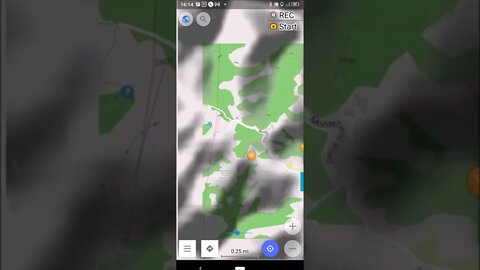
Testing out my custom hill shade layer for OSMand. Figured out how the transparency feature works, you can either have a transparent overlay on top of the base vector/topo map or you can have a transparent topo map on top of an underlay map, hill shade or other type of map.
If there's interest in seeing how I made this map, post up in the comment section below.
OSMand:
https://osmand.net/
USGS National Map Viewer:
https://apps.nationalmap.gov/viewer/
3D Elevation Program:
https://www.usgs.gov/3d-elevation-program
Subscribe for more content like this
Comment, rate, share & click the bell icon
And as always, thanks for watching
#USGS #HillShade #OSnd
4
views

Yet More Barbed Wire Fence Along the Grizzly Flat Road
A short stop on a bike ride up the Grizzly Flat / North Trail in Upper Stevens Creek County Park and what do you know, there's more barbed wire fence.
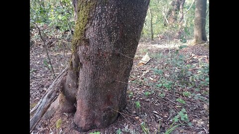
This location is a few hundred yards below the start of what I call the middle road which also has fence along the down hill side. Judging by the depth of wood that's grown around the barbed wire where it was fastened to live trees, both fences seem to be of similar age and construction.
What do you think this road/fence was built for? I'm starting to think there was some sort of ranch on this ridge, very similar to ranches on the next two ridges to the north. In upcoming videos, I'll try exploring some other areas to see if the location of any old ranch buildings can be found.
About the USGS HTMC:
https://www.usgs.gov/programs/national-geospatial-program/historical-topographic-maps-preserving-past
View/download maps on the TopoView site:
https://ngmdb.usgs.gov/topoview/
I used the 1897 Palo Alto quadrangle or the 1900 historical topo as listed in GaiaG:
https://www.gaiagps.com/
More to come...
Subscribe for more content like this
Comment, rate, share & click the bell icon
And as always, thanks for watching
#USGS #HillShade
15
views
Early June Rain in the Mountains
A short break on a bike ride up in the Santa Cruz Mtns. just as a light rain shower started. The rain continued for the rest of the ride up here, but never too heavy. I usually stay out of this area when it's stormy due to the high winds and the muddy trails, but this storm was calm and the trails stayed dry.
USGS Hill Shade map layer:
https://apps.nationalmap.gov/viewer/
About the USGS HTMC:
https://www.usgs.gov/programs/national-geospatial-program/historical-topographic-maps-preserving-past
View/download maps on the TopoView site:
https://ngmdb.usgs.gov/topoview/
I used the 1895 Palo Alto quadrangle or the 1900 historical topo as listed in GaiaG:
https://www.gaiagps.com/
More to come...
Subscribe for more content like this
Comment, rate, share & click the bell icon
And as always, thanks for watching
#USGS #HillShade
7
views

Live Hill Shade Map
Following up on an earlier video, I made a custom hill shade layer for OSMand and wanted to test it out.
Sorry for the portrait mode video, this app only displays that way.
Correction, it seems you need to have the "Auto Rotate" setting enabled in Android for this app to go into landscape mode.
If there's interest in seeing how I made this map, post up in the comment section below.
OSMand:
https://osmand.net/
USGS National Map Viewer:
https://apps.nationalmap.gov/viewer/
3D Elevation Program:
https://www.usgs.gov/3d-elevation-program
Subscribe for more content like this
Comment, rate, share & click the bell icon
And as always, thanks for watching
#USGS #HillShade #OSnd
1
view
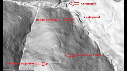
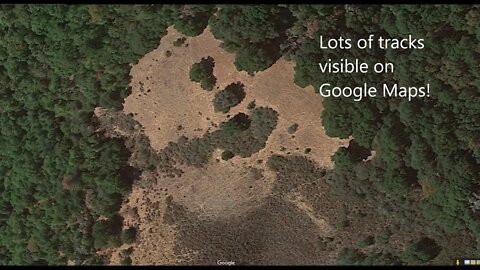
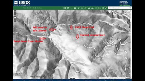
Grizzly Flat North Trail / What's at the Bottom of the Middle Road?
Another stop on a bike ride to check out an old road I saw near the middle of the Grizzly Flat / North Trail in Upper Stevens Creek County Park. After checking out the barbed wire fence remains, tried to make it down to the bottom of the Branch D canyon.
This road is very overgrown as it nears the bottom of the Branch D canyon due to the moist conditions. It seems there may have been an earlier road that made a large, sweeping turn and that may have slid out forcing a new road segment to be made. The newer road has very acute switchback turns that likely require backing down in a truck.
Also got to see the bottom of the old road that runs up the side of the ridge to Skyline Blvd. (Hwy. 35). I'll need to have a "live" hill shade map to explore more of this road as it's very faint in sections.
None of these roads appear on any maps. Grizzly Flat North Road first appears on the 1961 USGS topo map.
There appear to be at least 3 roads that come together at the bottom of the Branch D canyon. 2 of them seem to be quite old based on their minimal construction. Then this road seems more modern in terms of wider radius turns and that it joins up to an existing road. But then the question is, what was this built road for? Were the 2 older roads in the canyon still in use when this road was built? If not, then why did this road go down to the same area that the 2 old roads seem to meet up in? Maybe this road was abandoned when the county acquired this land for the county park in 1965.
It's about of a mile and 300 feet elevation drop (1.6km / 90m) from Grizzly Flat trail down to the bottom of the canyon on foot. Then it's a further 18.5 miles (30km) by bike on dirt and pavement to get here and back from home. Ends up being at least a 6 hour trip up here.
About the USGS HTMC:
https://www.usgs.gov/programs/national-geospatial-program/historical-topographic-maps-preserving-past
View/download maps on the TopoView site:
https://ngmdb.usgs.gov/topoview/
I used the 1897 Palo Alto quadrangle or the 1900 historical topo as listed in GaiaG:
https://www.gaiagps.com/
More to come...
Subscribe for more content like this
Comment, rate, share & click the bell icon
And as always, thanks for watching
#USGS #HillShade
11
views
Grizzly Flat North Trail / What was this Middle Road built for?
Another stop on a bike ride to check out an old road I saw near the middle of the Grizzly Flat / North Trail in Upper Stevens Creek County Park. Following up on an earlier video to check out the barbed wire fence and also look for signs of old tree stumps or other signs of logging in the area. This road seems to have been built for decent sized trucks, judging by the large radius curves, but not sure of the purpose.
The first trip down here, I only noticed a few fence posts, but by this 4th trip, I saw fence posts and barbed wire all along the road. The fence seemed to only run along the downhill side of the road and not cut across between curves in the road as if it were following a straight property line.
I don't see any signs of logging in this area, at least for large Redwood trees that were commonly harvested in the western Santa Cruz Mountains. My guess is that with the drier climate on the east side of the mountains, coupled with the rugged topography, logging was not economically feasible. The density of large Redwood trees is fairly low and the cost of building lots of roads in the steep, slide prone canyon would be too high.
What do you think this road/fence was built for?
This road doesn't appear on any maps. It looks like it may been constructed around the same time as the Grizzly Flat road. Grizzly Flat North Road first appears on the 1961 USGS topo map.
There appear to be at least 3 roads that come together at the bottom of the Branch D canyon. 2 of them seem to be quite old based on their minimal construction. Then this road seems more modern in terms of wider radius turns and that it joins up to an existing road. But then the question is, what was this built road for? Were the 2 older roads in the canyon still in use when this road was built? If not, then why did this road go down to the same area that the 2 old roads seem to meet up in? Maybe this road was abandoned when the county acquired this land for the county park in 1965.
In the next video, we'll try to follow the road to the bottom of the canyon.
Oneal Ranch:
https://www.openspace.org/preserves/los-trancos#history
This is ~2 miles north on Montebello Ridge.
E Ranch:
https://www.paloaltoonline.com/news/2014/03/21/cover-story-a-gem-of-open-space
This is on the north side of the Branch D canyon.
About the USGS HTMC:
https://www.usgs.gov/programs/national-geospatial-program/historical-topographic-maps-preserving-past
View/download maps on the TopoView site:
https://ngmdb.usgs.gov/topoview/
I used the 1897 Palo Alto quadrangle or the 1900 historical topo as listed in GaiaG:
https://www.gaiagps.com/
More to come...
Subscribe for more content like this
Comment, rate, share & click the bell icon
And as always, thanks for watching
#USGS #HillShade
52
views
Hill Shade Apps
Following up on an earlier video where I mentioned:
"Apparently GaiaG is looking into adding a hill shade option. It seems that OSMand may have a hill shade option in the Maps+ version that I may need to try out."
This is the "Terrain HD" layer in GaiaG, finally figured out that I was zooming in too far and the shaded tiles were disappearing.
Sorry for the portrait mode video, but both apps only display that way. GaiaG does have a web interface that does landscape, but OSMand doesn't.
The Wikipedia layer is quite interesting and after reviewing this footage, I noticed I missed something related to a previous video. Stay tuned for an upcoming video looking at that...
GaiaG:
https://www.gaiagps.com/
OSMand:
https://osmand.net/
USGS National Map Viewer:
https://apps.nationalmap.gov/viewer/
3D Elevation Program:
https://www.usgs.gov/3d-elevation-program
Subscribe for more content like this
Comment, rate, share & click the bell icon
And as always, thanks for watching
#USGS #HillShade
2
views
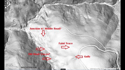
Grizzly Flat North Trail / Middle Road: 3rd Visit
Another stop on a bike ride to check out an old road I saw near the middle of the Grizzly Flat / North Trail in Upper Stevens Creek County Park. Main goal was to locate 2 features that show up on the hill shade map, one a steep area along the south side of Branch D that may have slid and taken out the old 1897 road. The other feature seems to be a steep gully beside the road that also runs down to Branch D. Way points at these 2 features helped in lining up the topo may over the hill shade map.
A few things to look for in upcoming visits are if the barbed wire fence is only along the road or if it runs in a straighter line between the curves in the road (i.e. a property boundary). Also, need to check for signs of old tree stumps or other signs of logging in the area. This road seems to have been built for decent sized trucks, judging by the large radius curves, but not sure of the purpose.
This road doesn't appear on any maps. It looks like it may been constructed around the same time as the Grizzly Flat road. Grizzly Flat North Road first appears on the 1961 USGS topo map.
There appear to be at least 3 roads that come together at the bottom of the Branch D canyon. 2 of them seem to be quite old based on their minimal construction. Then this road seems more modern in terms of wider radius turns and that it joins up to an existing road. But then the question is, what was this built road for? Were the 2 older roads in the canyon still in use when this road was built? If not, then why did this road go down to the same area that the 2 old roads seem to meet up in? Maybe this road was abandoned when the county acquired this land for the county park in 1965.
Hopefully can make it to the bottom and see if there's any sign of these old roads connecting as it appears on the hill shade map, I think I got within 100 yds/m of the bottom.
About the USGS HTMC:
https://www.usgs.gov/programs/national-geospatial-program/historical-topographic-maps-preserving-past
View/download maps on the TopoView site:
https://ngmdb.usgs.gov/topoview/
I used the 1897 Palo Alto quadrangle or the 1900 historical topo as listed in GaiaG:
https://www.gaiagps.com/
More to come...
Subscribe for more content like this
Comment, rate, share & click the bell icon
And as always, thanks for watching
#USGS #HillShade
18
views

Grizzly Flat North Trail / Middle Road: 2nd Visit
Short stop on a bike ride to check out an old road I saw near the middle of the Grizzly Flat / North Trail in Upper Stevens Creek County Park. Wanted to see where it went and if it may have connected down to the end of the 1897 road at the end of Stevens Creek Branch D.
This road doesn't appear on any maps. It looks like it may been constructed around the same time as the Grizzly Flat road. Grizzly Flat North Road first appears on the 1961 USGS topo map.
There appear to be at least 3 roads that come together at the bottom of the Branch D canyon. 2 of them seem to be quite old based on their minimal construction. Then this road seems more modern in terms of wider radius turns and that it joins up to an existing road. But then the question is, what was this built road for? Were the 2 older roads in the canyon still in use when this road was built? If not, then why did this road go down to the same area that the 2 old roads seem to meet up in? Maybe this road was abandoned when the county acquired this land for the county park in 1965.
About the USGS HTMC:
https://www.usgs.gov/programs/national-geospatial-program/historical-topographic-maps-preserving-past
View/download maps on the TopoView site:
https://ngmdb.usgs.gov/topoview/
I used the 1897 Palo Alto quadrangle or the 1900 historical topo as listed in GaiaG:
https://www.gaiagps.com/
More to come...
Subscribe for more content like this
Comment, rate, share & click the bell icon
And as always, thanks for watching
#USGS #HillShade
5
views

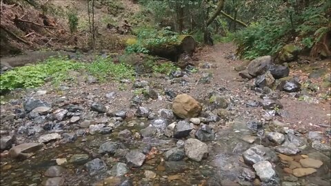
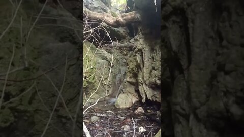
Water Wheel Creek: Waterfalls and More...
Checking out the top end of the waterfall canyon on Water Wheel Creek. This is located near the bottom of the switchbacks on the Grizzly Flat Trail where it drops down to cross Stevens Creek.
This is the upper most fall in the lower canyon. Water is pouring out down here even though the above ground channel is dry. Lots of flowstone in here with a couple of stalactites. Stay tuned to the end for a cool shot of an infinity pool fed by a waterfall!
This whole area seems to be part of a 1/2 mile long tectonic block that's been tilted by the San Andreas fault. It seems to have slid down the northern slope of the canyon and tilted noticeably as well as being displaced in the direction of the Pacific plate motion.
This would be an excellent area to study for a graduate student in geology. It should be possible to get some dating information from the abundant travertine deposits.
According to the USGS maps, there's no creek here. On the USGS maps, what I'm calling Waterwheel Creek flows down to the east from here, not to the west.
Normally, a Speleothem is in a cave (a.k.a. a Karst), but this Speleothem is flowing over a Karst. There's a large Speleothem along the paved portion of Stevens Canyon Road.
Speleothem:
https://en.wikipedia.org/wiki/Speleothem
Location:
https://www.google.com/maps/@37.2968397,-122.141266,17.17z
Another tidbit, the 1838 earthquake epicenter was located almost at this location:
https://en.wikipedia.org/wiki/1838_San_Andreas_earthquake
Magnitude estimated in the 6.8 - 7.2 range, surrounding areas saw over 5 ft/1.6 m displacement. Found this out with the Wikipedia layer in the OSMand mapping app.
More to come...
Subscribe for more content like this
Comment, rate, share & click the bell icon
And as always, thanks for watching
4
views
Travertine waterfall #3
Waterwheel Creek, dropping down from Montebello Ridge, just before entering Stevens Creek. This is ground water emerging from the limestone bedrock, leaving calcium carbonate minerals behind. This is known as a speleothem, but formed above ground and this is with cold water. If this were in a cave, it might be called a "Flow Stone" or "Stalactite". This isn't the only Speleothem in Stevens Creek Canyon either.
We've had some rain in the last week or so, still nothing showing in the above ground stream bed. Lots of ground water in the lower part of the canyon, this is about the 4th cascade up from the bottom.
Stay tuned for a longer video at this location...
Another a YouTube #Shorts video
1
view
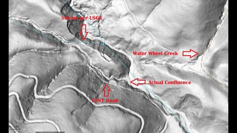
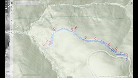
Stevens Creek / Grizzly Flat Crossing
The 1897 topo map shows the old Stevens Canyon Road continuing beyond the location of the modern Grizzly Flat Trail, but the new USGS hill shade layer shows it continuing much farther up the Branch D canyon.
I had thought about trying this lower access again after seeing how steep the route down from above was. Unfortunately, with the recent rains and warmer weather, the poison oak has grown up, covering the old road. This part of the road is off the table until the greenery dies back this coming fall/winter. I think it's possible to get across the large downed trees that stopped my earlier attempt.
This area has always been puzzling as the topo maps to not match with what's on the ground. For the longest time, I didn't quite trust what I was seeing, but after exploring off the beaten path, I'm sure the current topo maps are incorrect.
This whole upper canyon area is very rugged and aside from a few old roads through it, there's not been a lot of activity up here, at least in the canyon. As far back as the DeAnza expedition in 1775/6, it was noted that this canyon was only useful as a means of getting from the mountains to the valley, but was otherwise too rugged for farming, etc. As a result, it seems there's been little development up here and it's not been well surveyed. Ironic, as the USGS west coast campus is under 15 miles away from here.
About the USGS HTMC:
https://www.usgs.gov/programs/national-geospatial-program/historical-topographic-maps-preserving-past
View/download maps on the TopoView site:
https://ngmdb.usgs.gov/topoview/
I used the 1895/7 Palo Alto quadrangle or the 1900 historical topo as listed in GaiaG:
https://www.gaiagps.com/
More to come...
Subscribe for more content like this
Comment, rate, share & click the bell icon
And as always, thanks for watching
#USGS #HillShade
10
views
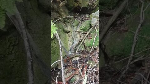
Travertine waterfall #2
Waterwheel Creek, dropping down from Montebello Ridge, just before entering Stevens Creek. This is ground water emerging from the limestone bedrock, leaving calcium carbonate minerals behind. This is known as a speleothem, but formed above ground and this is with cold water. If this were in a cave, it might be called a "Flow Stone" or something like that. This isn't the only Speleothem in Stevens Creek Canyon either.
We've had some rain in the last week or so, still nothing showing in the above ground stream bed. Lots of ground water in the lower part of the canyon, this is about the 3rd cascade up from the bottom.
Trying another a YouTube #Shorts video
2
views

The Enigmatic Water Wheel Creek
Where is it? Which way does it flow? You won't find the answer on any map!
Geologic Analysis Of The Monte Bello Ridge Mountain Study Area paper:
https://fbdroch.com/book/environmental-geologic-analysis-of-the-monte-bello-ridge-mountain-study-area-santa-clara-county-california
From that paper:
"TECTONIC BLOCKS - Large angular to rounded, commonly elliptically shaped masses of relatively hard rocks surrounded by a clay-rich, sheared matrix. Occurs within shear zones and fault gouge. In the shear zones of the Franciscan rocks, these blocks range from "fist size" to masses more than one mile long."
Sag Pond:
https://en.wikipedia.org/wiki/Sag_pond
GeoCache/EarthCache:
https://www.geocaching.com/geocache/GCMMZ6_sag-ponds-on-the-san-andreas-fault
USGS National Map Viewer w/ Hill Shade:
https://apps.nationalmap.gov/viewer/
About the USGS HTMC:
https://www.usgs.gov/programs/national-geospatial-program/historical-topographic-maps-preserving-past
View/download maps on the TopoView site:
https://ngmdb.usgs.gov/topoview/
Section of single track Canyon Trail built in 1990:
https://www.trailcenter.org/newsletter/2000/winter2000/winter2000-19f.htm
Future plan: I want to try to hike along the top of the ridge between the Canyon Trail and Stevens Creek between the Table Mtn. and Grizzly Flat trails. I'm hoping there might be some exposed sedimentary rock outcrops up there that might show if this block has been tilted in the past.
More to come...
Subscribe for more content like this
Comment, rate, share & click the bell icon
And as always, thanks for watching
#USGS #HillShade
29
views
Checking out the Middle Road on the Grizzly Flat North Trail
Short stop on a bike ride to check out an old road I saw near the middle of the Grizzly Flat / North Trail in Upper Stevens Creek County Park. Wanted to see where it went and if it may have connected down to the end of the 1897 road at the end of Stevens Creek Branch D.
This road doesn't appear on any maps. It looks like it may been constructed around the same time as the Grizzly Flat road. Grizzly Flat North Road first appears on the 1961 USGS topo map.
There appear to be at least 3 roads that come together at the bottom of the Branch D canyon. 2 of them seem to be quite old based on their minimal construction. Then this road seems more modern in terms of wider radius turns and that it joins up to an existing road. But then the question is, what was this built road for? Were the 2 older roads in the canyon still in use when this road was built? If not, then why did this road go down to the same area that the 2 old roads seem to meet up in? Maybe this road was abandoned when the county acquired this land for the county park in 1965.
This road is worth of a return visit when I have some more time and also some leg covering in case it gets more overgrown as it descends. As is, I only had on my cycling shorts and luckily the upper 200 yds. I travelled was quite passable. Hopefully can make it to the bottom and see if there's any sign of these old roads connecting as it appears on the hill shade map.
About the USGS HTMC:
https://www.usgs.gov/programs/national-geospatial-program/historical-topographic-maps-preserving-past
View/download maps on the TopoView site:
https://ngmdb.usgs.gov/topoview/
I used the 1897 Palo Alto quadrangle or the 1900 historical topo as listed in GaiaG:
https://www.gaiagps.com/
More to come...
Subscribe for more content like this
Comment, rate, share & click the bell icon
And as always, thanks for watching
#USGS #HillShade
10
views