Grizzly Flat Trail, North/South Trail Junction, Closer Look
A return visit to the middle junction of the Grizzly Flat North and South trails. There's a short spur called the Grizzly Flat Cutoff Trail that joins the 2 trails here. Had more time this visit to spend exploring this area.
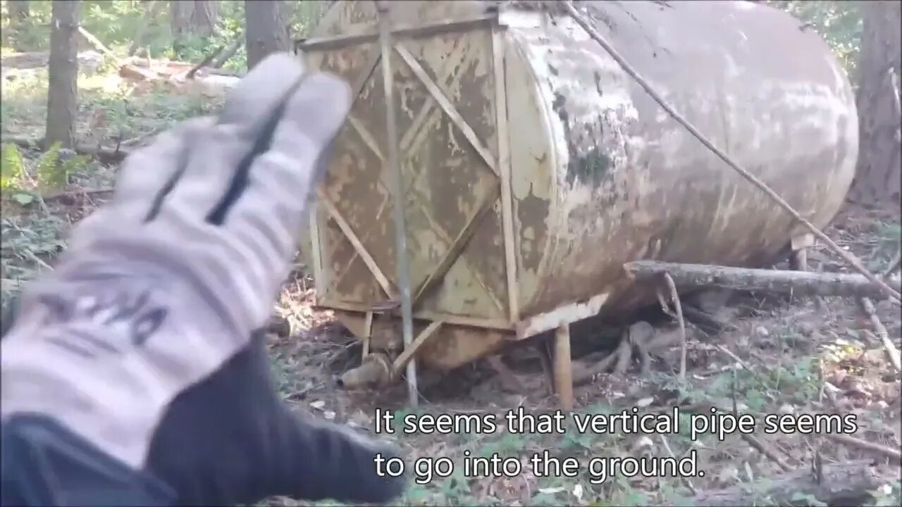
This is the only large, relatively flat area on this entire ridge. There's a large steel tank here, upon closer inspection, it appears to be around 5000 gallons. I wonder if that vertical pipe runs underground to a water source? Would need to use a metal detector to try and trace where it goes.
Looks like I've finally dialed in the DIY hill shade map calibration. Found the 2 "humps" or piles of dirt at the east end of this area along with the large ditch in the middle. This area has been leveled and a fair amount of earth moved both for that as well as the ditch.
What do you think this area was used for?
About the USGS hill shade maps:
https://apps.nationalmap.gov/viewer/
More to come, exploring off the the north east looking for signs of pipe and fencing and what looks like a faint trail...
Subscribe for more content like this
Comment, rate, share & click the bell icon
And as always, thanks for watching
#USGS #HillShade
-
 LIVE
LIVE
Trumpet Daily
15 minutes agoTrumpet Daily LIVE - July 31, 2025
68 watching -
 LIVE
LIVE
LFA TV
14 hours agoLFA TV ALL DAY STREAM - THURSDAY 7/31/25
4,751 watching -
 LIVE
LIVE
JuicyJohns
3 hours ago $1.57 earned🟢#1 REBIRTH PLAYER 10.2+ KD🟢$500 GIVEAWAY SATURDAY!
127 watching -
 43:09
43:09
VINCE
3 hours agoSPECIAL: "Obamagate" DEEP-DIVE with Gen. Mike Flynn, Mike Benz and Paul Sperry
87.1K65 -
 LIVE
LIVE
The Big Mig™
3 hours agoFBI Burn Bags, Hidden SCIF’s & Truth About Mar-A-Lago Raid
5,248 watching -
 1:50:11
Dear America
3 hours agoFBI Discovers THOUSANDS Russia Hoax Docs In “Burn Bags”!! + Pelosi EXPOSED For Insider Trading!!
103K77 -
 1:27:12
Tucker Carlson
3 hours agoTony Aguilar Details the War Crimes He’s Witnessing in Gaza
71.6K125 -
 LIVE
LIVE
Badlands Media
6 hours agoBadlands Daily: July 31, 2025
3,709 watching -
 2:16:31
Matt Kohrs
12 hours agoHUGE Earnings Beat, Inflation Data & New Record Highs || Live Trading Options & Futures
28.7K2 -
 19:44
19:44
Bearing
4 hours agoWorld’s CRAZIEST Feminist Wants AMERICANS to WAKE THE F*** UP 🦅💥
18.2K37