The Enigmatic Water Wheel Creek
Where is it? Which way does it flow? You won't find the answer on any map!
Geologic Analysis Of The Monte Bello Ridge Mountain Study Area paper:
https://fbdroch.com/book/environmental-geologic-analysis-of-the-monte-bello-ridge-mountain-study-area-santa-clara-county-california
From that paper:
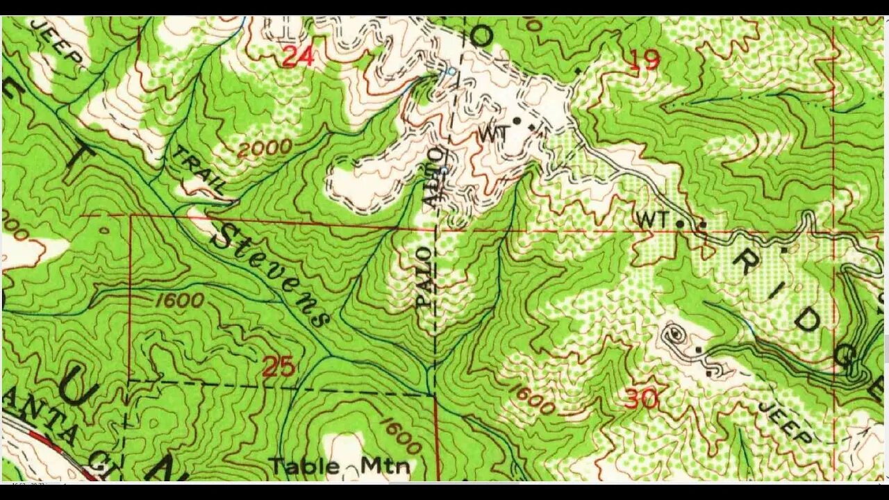
"TECTONIC BLOCKS - Large angular to rounded, commonly elliptically shaped masses of relatively hard rocks surrounded by a clay-rich, sheared matrix. Occurs within shear zones and fault gouge. In the shear zones of the Franciscan rocks, these blocks range from "fist size" to masses more than one mile long."
Sag Pond:
https://en.wikipedia.org/wiki/Sag_pond
GeoCache/EarthCache:
https://www.geocaching.com/geocache/GCMMZ6_sag-ponds-on-the-san-andreas-fault
USGS National Map Viewer w/ Hill Shade:
https://apps.nationalmap.gov/viewer/
About the USGS HTMC:
https://www.usgs.gov/programs/national-geospatial-program/historical-topographic-maps-preserving-past
View/download maps on the TopoView site:
https://ngmdb.usgs.gov/topoview/
Section of single track Canyon Trail built in 1990:
https://www.trailcenter.org/newsletter/2000/winter2000/winter2000-19f.htm
Future plan: I want to try to hike along the top of the ridge between the Canyon Trail and Stevens Creek between the Table Mtn. and Grizzly Flat trails. I'm hoping there might be some exposed sedimentary rock outcrops up there that might show if this block has been tilted in the past.
More to come...
Subscribe for more content like this
Comment, rate, share & click the bell icon
And as always, thanks for watching
#USGS #HillShade
-
 1:50:27
Athlete & Artist Show
5 hours ago $2.32 earnedStanley Cup LIVE Watch Party | Oilers vs Stars
13.7K1 -
 1:06:27
Jeff Ahern
3 hours ago $4.97 earnedThe Sunday Show with Jeff Ahern
35.5K8 -
 21:48
21:48
DeVory Darkins
1 day agoTrump VICTORY SPEECH stuns West Point as Dems PANIC over meme coin
27.3K79 -
 7:14:04
Total Horse Channel
19 hours agoCMSA National Championship - Sunday
68K1 -
 42:17
42:17
Athlete & Artist Show
5 hours ago $1.27 earnedZach Boychuk Signs In Slovenia, Conference Finals, Denmark UPSETS Canada?!
14.1K -
 18:26
18:26
Mrgunsngear
1 day ago $15.81 earnedDNT Optics Hydra Thermal Optic Review
71.2K22 -
 17:22
17:22
Clownfish TV
2 days agoWill MCU X-Men Be WOKE? Disney CEO Wants ACTION!
91.2K69 -
 19:33
19:33
Chris From The 740
5 hours ago $1.71 earnedCyelee Wolf EDG Review: Rugged Enclosed Emitter and Perfect for EDC!
20.6K4 -
 LIVE
LIVE
iAmtyrantt
5 hours ago $0.53 earnedSplitgate 2 Beta!! #taketheOath
108 watching -
 LIVE
LIVE
Bleariio
5 hours agoDays Gone LIVE – Freakers, Bikes, and Survival!
96 watching