Stevens Creek / Grizzly Flat Crossing
The 1897 topo map shows the old Stevens Canyon Road continuing beyond the location of the modern Grizzly Flat Trail, but the new USGS hill shade layer shows it continuing much farther up the Branch D canyon.
I had thought about trying this lower access again after seeing how steep the route down from above was. Unfortunately, with the recent rains and warmer weather, the poison oak has grown up, covering the old road. This part of the road is off the table until the greenery dies back this coming fall/winter. I think it's possible to get across the large downed trees that stopped my earlier attempt.
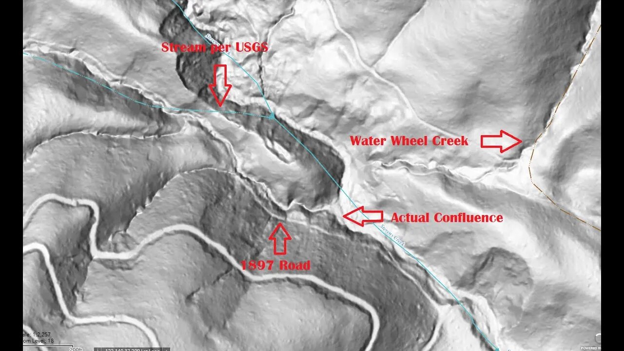
This area has always been puzzling as the topo maps to not match with what's on the ground. For the longest time, I didn't quite trust what I was seeing, but after exploring off the beaten path, I'm sure the current topo maps are incorrect.
This whole upper canyon area is very rugged and aside from a few old roads through it, there's not been a lot of activity up here, at least in the canyon. As far back as the DeAnza expedition in 1775/6, it was noted that this canyon was only useful as a means of getting from the mountains to the valley, but was otherwise too rugged for farming, etc. As a result, it seems there's been little development up here and it's not been well surveyed. Ironic, as the USGS west coast campus is under 15 miles away from here.
About the USGS HTMC:
https://www.usgs.gov/programs/national-geospatial-program/historical-topographic-maps-preserving-past
View/download maps on the TopoView site:
https://ngmdb.usgs.gov/topoview/
I used the 1895/7 Palo Alto quadrangle or the 1900 historical topo as listed in GaiaG:
https://www.gaiagps.com/
More to come...
Subscribe for more content like this
Comment, rate, share & click the bell icon
And as always, thanks for watching
#USGS #HillShade
-
 LIVE
LIVE
Drew Hernandez
6 hours agoISRAEL BOMBS GAZA HOSPITAL ON LIVE TV KILLING AT LEAST 20 INCLUDING JOURNALISTS & CIVILIANS
708 watching -
 2:55:23
TimcastIRL
5 hours agoTrump Orders Specialized National Guard Units To Combat Crime In Cities, Dems Furious | Timcast IRL
171K120 -

SpartakusLIVE
7 hours ago#1 Rocket CHAMPION of Verdansk wields UNSTOPPABLE new META
64.2K5 -
 2:55:11
Barry Cunningham
7 hours agoPRESIDENT TRUMP MADE TODAY A VERY BAD DAY TO BE A DEMOCRAT!
86.8K54 -
 1:15:29
Flyover Conservatives
1 day agoFrom Cool to Cringe: How Democrats Lost America’s Ear | FOC Show
32.4K12 -
 8:19
8:19
MattMorseTV
10 hours ago $4.41 earnedTrump is ACTUALLY DOING IT.
36.5K37 -
 11:30:43
ZWOGs
13 hours ago🔴LIVE IN 1440p! - Tarkov w/ Casey & crgoodw1n, Kingdom Come Deliverance, & More - Come Hang Out!
32.2K5 -
 2:30:56
We Like Shooting
17 hours ago $1.77 earnedWe Like Shooting 625 (Gun Podcast)
28K1 -
 1:45:02
Glenn Greenwald
8 hours agoIsrael Slaughters More Journalists, Hiding War Crimes; Trump's Unconstitutional Flag Burning Ban; Glenn Takes Your Questions | SYSTEM UPDATE #504
132K168 -
 1:29:31
Killerperk
4 hours ago $0.74 earnedRoad to BF6. Come hang out #regiment #bf6
30.2K2