
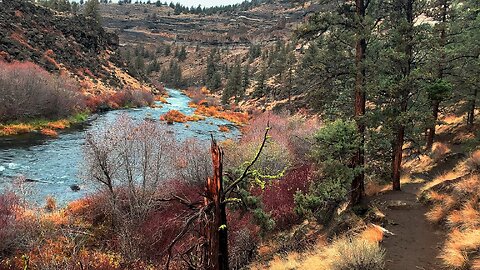
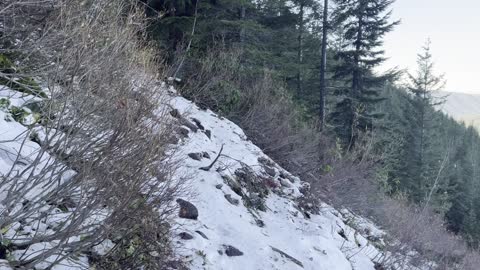
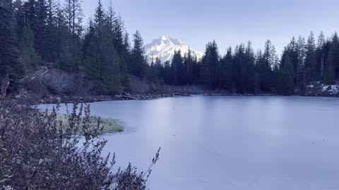
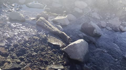
4K HIGHLIGHTS of EPIC Steelhead Falls Wilderness Area & Deschutes River in AUTUMN FALL COLORS 4K!
This was a day-hike in Central Oregon, Steelhead Falls Wilderness Study Area, starting at Steelhead Falls Trailhead and hiking a truly epic 2 Mile Out and Back, approximately 226 FT Elevation Gain (mostly on the way back up), descending into the incredible Deschutes River Desert Canyon Basin culminating in the spectacular Steelhead Falls! This was hiked on 11/2/2021 with AUTUMN FALL COLORS in full bloom! If you just want to go to the Steelhead Falls Lookout Zone and back it is only half of that distance, 1 Mile Roundtrip. If you go past that you get to a more rugged section of trail and take that all the way to the end of the Desert Basin Canyon. Weather was a low of 40, high of 56, overcast cloudy day and mildly windy. Trail was completely clear of snow, and there were NO Mosquitoes! On Alltrails, this hike is called "Steelhead Falls". As far as road conditions, it's highway and paved side streets until the last few tenths of a mile or so which is gravel, you want to take this part slowly and cautiously but it's fairly easy, in my opinion, the road most definitely DOES NOT require 4-Wheel Drive. As far as permits, the Steelhead Falls Trailhead DOES NOT require a Recreation.gov permit.
326
views
2
comments
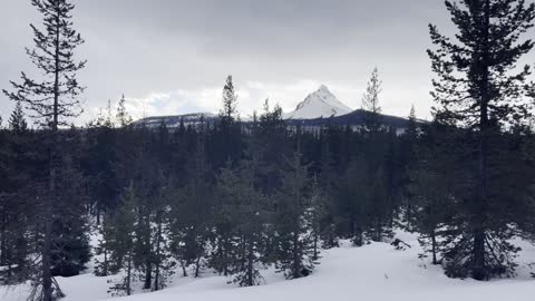
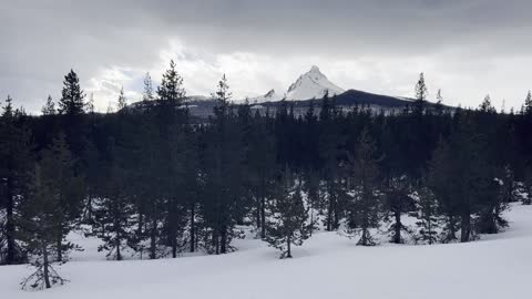
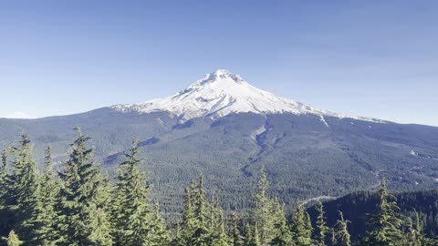
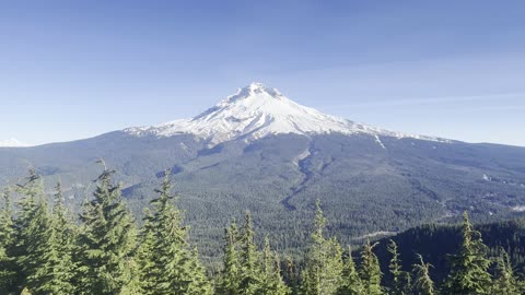
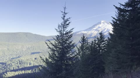
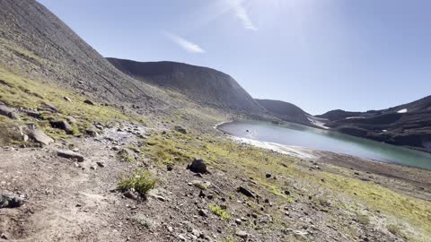
THE INCREDIBLE MOUNT WASHINGTON!!!!!!!!!!!!!!!!!! – Ray Benson Sno-Park – Central Oregon – 4K
My goal of these wilderness trail videos is to 1) show reverence for the beauty of the land, and 2) give YOU actionable trail information that can assist you in planning your own hike here.
This was a day-hike in Central Oregon, Willamette National Forest, Ray Benson Sno Park, hiking South Loop by Hayrick Butte and Claypool Butte to Brandeberg Butte and Brandenberg Rustic Log Cabin Shelter, approximately 5.8 miles and 350 FT Elevation Gain. With some other Ray Benson Sno-Park Exploration and hiking Claypool Butte I do more like 7 miles and 500 FT Elevation Gain. ***A WORD OF CAUTION - I WOULD NOT RECOMMEND TAKING THE ALLTRAILS ROUTE OF A LOLLIPOP - once you get to Brandenberg Shelter, I would recommend turning around and backtracking making it an Out and Back. That may seem counterintuitive since you are immediately going back uphill, however that is still less exertion than the next two miles on the Lollipop Loop to connect back to the Stick so to speak since it is not a well defined grooved or packed down trail! That two miles was the hardest of the whole hike, had to break trail and use GPS to track the way through the forest since the path wasn't at all evident. There also aren't really any good views in that section, mostly just meadows and thick forest, so I would highly recommend skipping that and going back up Brandenberg Butte so you get the Mountain Views again and stay on a more trackable path.*** Snowshoes in my humble opinion are a must, I would not attempt this is Yaktrax because several sections are just too thick of snow to not be postholing for miles. This was the warmest day in a long time, low of 31 around Sunrise when I got there with a high of 43, however it did likely sprinkle for hours combined with the winds made this a particularly wet and cold hike given the weather profile going in. This was hiked on 1/13/2023, yes Friday the 13th!, and there were of NO Mosquitoes. As far as road conditions, it's highway and well paved roads until the turnoff for Ray Benson Sno-Park, the last couple tenths although on a well defined road were actually pretty slippery and icy, and the giant parking lot was also a sheet of ice. In my opinion, the road DOES NOT require 4-Wheel Drive, however do watch for road conditions, particularly snow/ice depending on the time of year and drive VERY CAUTIOUSLY.
161
views
9
comments
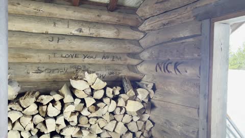
STOP DOING GRAFFITI ON RUSTIC LOG CABIN SHELTERS! – Ray Benson Sno-Park – Central Oregon – 4K
My goal of these wilderness trail videos is to 1) show reverence for the beauty of the land, and 2) give YOU actionable trail information that can assist you in planning your own hike here.
This was a day-hike in Central Oregon, Willamette National Forest, Ray Benson Sno Park, hiking South Loop by Hayrick Butte and Claypool Butte to Brandeberg Butte and Brandenberg Rustic Log Cabin Shelter, approximately 5.8 miles and 350 FT Elevation Gain. With some other Ray Benson Sno-Park Exploration and hiking Claypool Butte I do more like 7 miles and 500 FT Elevation Gain. ***A WORD OF CAUTION - I WOULD NOT RECOMMEND TAKING THE ALLTRAILS ROUTE OF A LOLLIPOP - once you get to Brandenberg Shelter, I would recommend turning around and backtracking making it an Out and Back. That may seem counterintuitive since you are immediately going back uphill, however that is still less exertion than the next two miles on the Lollipop Loop to connect back to the Stick so to speak since it is not a well defined grooved or packed down trail! That two miles was the hardest of the whole hike, had to break trail and use GPS to track the way through the forest since the path wasn't at all evident. There also aren't really any good views in that section, mostly just meadows and thick forest, so I would highly recommend skipping that and going back up Brandenberg Butte so you get the Mountain Views again and stay on a more trackable path.*** Snowshoes in my humble opinion are a must, I would not attempt this is Yaktrax because several sections are just too thick of snow to not be postholing for miles. This was the warmest day in a long time, low of 31 around Sunrise when I got there with a high of 43, however it did likely sprinkle for hours combined with the winds made this a particularly wet and cold hike given the weather profile going in. This was hiked on 1/13/2023, yes Friday the 13th!, and there were of NO Mosquitoes. As far as road conditions, it's highway and well paved roads until the turnoff for Ray Benson Sno-Park, the last couple tenths although on a well defined road were actually pretty slippery and icy, and the giant parking lot was also a sheet of ice. In my opinion, the road DOES NOT require 4-Wheel Drive, however do watch for road conditions, particularly snow/ice depending on the time of year and drive VERY CAUTIOUSLY.
156
views
5
comments
Descending STEEP Butte & Arriving at Brandenberg Shelter! – Ray Benson Sno-Park – Central Oregon – 4K
My goal of these wilderness trail videos is to 1) show reverence for the beauty of the land, and 2) give YOU actionable trail information that can assist you in planning your own hike here.
This was a day-hike in Central Oregon, Willamette National Forest, Ray Benson Sno Park, hiking South Loop by Hayrick Butte and Claypool Butte to Brandeberg Butte and Brandenberg Rustic Log Cabin Shelter, approximately 5.8 miles and 350 FT Elevation Gain. With some other Ray Benson Sno-Park Exploration and hiking Claypool Butte I do more like 7 miles and 500 FT Elevation Gain. ***A WORD OF CAUTION - I WOULD NOT RECOMMEND TAKING THE ALLTRAILS ROUTE OF A LOLLIPOP - once you get to Brandenberg Shelter, I would recommend turning around and backtracking making it an Out and Back. That may seem counterintuitive since you are immediately going back uphill, however that is still less exertion than the next two miles on the Lollipop Loop to connect back to the Stick so to speak since it is not a well defined grooved or packed down trail! That two miles was the hardest of the whole hike, had to break trail and use GPS to track the way through the forest since the path wasn't at all evident. There also aren't really any good views in that section, mostly just meadows and thick forest, so I would highly recommend skipping that and going back up Brandenberg Butte so you get the Mountain Views again and stay on a more trackable path.*** Snowshoes in my humble opinion are a must, I would not attempt this is Yaktrax because several sections are just too thick of snow to not be postholing for miles. This was the warmest day in a long time, low of 31 around Sunrise when I got there with a high of 43, however it did likely sprinkle for hours combined with the winds made this a particularly wet and cold hike given the weather profile going in. This was hiked on 1/13/2023, yes Friday the 13th!, and there were of NO Mosquitoes. As far as road conditions, it's highway and well paved roads until the turnoff for Ray Benson Sno-Park, the last couple tenths although on a well defined road were actually pretty slippery and icy, and the giant parking lot was also a sheet of ice. In my opinion, the road DOES NOT require 4-Wheel Drive, however do watch for road conditions, particularly snow/ice depending on the time of year and drive VERY CAUTIOUSLY.
60
views
2
comments
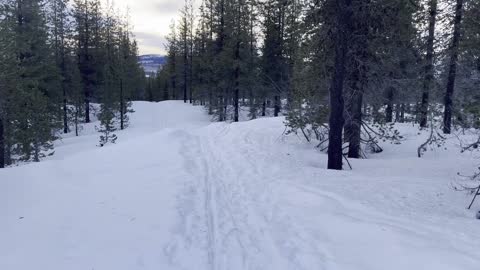
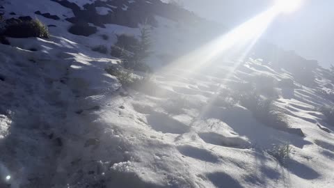
EXPLORING THE INCREDIBLE ALPINE WONDERLAND VIA SNOWSHOE! – Ray Benson Sno-Park – Central Oregon – 4K
My goal of these wilderness trail videos is to 1) show reverence for the beauty of the land, and 2) give YOU actionable trail information that can assist you in planning your own hike here.
This was a day-hike in Central Oregon, Willamette National Forest, Ray Benson Sno Park, hiking South Loop by Hayrick Butte and Claypool Butte to Brandeberg Butte and Brandenberg Rustic Log Cabin Shelter, approximately 5.8 miles and 350 FT Elevation Gain. With some other Ray Benson Sno-Park Exploration and hiking Claypool Butte I do more like 7 miles and 500 FT Elevation Gain. ***A WORD OF CAUTION - I WOULD NOT RECOMMEND TAKING THE ALLTRAILS ROUTE OF A LOLLIPOP - once you get to Brandenberg Shelter, I would recommend turning around and backtracking making it an Out and Back. That may seem counterintuitive since you are immediately going back uphill, however that is still less exertion than the next two miles on the Lollipop Loop to connect back to the Stick so to speak since it is not a well defined grooved or packed down trail! That two miles was the hardest of the whole hike, had to break trail and use GPS to track the way through the forest since the path wasn't at all evident. There also aren't really any good views in that section, mostly just meadows and thick forest, so I would highly recommend skipping that and going back up Brandenberg Butte so you get the Mountain Views again and stay on a more trackable path.*** Snowshoes in my humble opinion are a must, I would not attempt this is Yaktrax because several sections are just too thick of snow to not be postholing for miles. This was the warmest day in a long time, low of 31 around Sunrise when I got there with a high of 43, however it did likely sprinkle for hours combined with the winds made this a particularly wet and cold hike given the weather profile going in. This was hiked on 1/13/2023, yes Friday the 13th!, and there were of NO Mosquitoes. As far as road conditions, it's highway and well paved roads until the turnoff for Ray Benson Sno-Park, the last couple tenths although on a well defined road were actually pretty slippery and icy, and the giant parking lot was also a sheet of ice. In my opinion, the road DOES NOT require 4-Wheel Drive, however do watch for road conditions, particularly snow/ice depending on the time of year and drive VERY CAUTIOUSLY.
49
views
1
comment
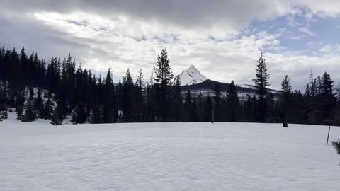
EPIC Views of MOUNT WASHINGTON from Brandenberg Butte! – Ray Benson Sno-Park – Central Oregon – 4K
My goal of these wilderness trail videos is to 1) show reverence for the beauty of the land, and 2) give YOU actionable trail information that can assist you in planning your own hike here.
This was a day-hike in Central Oregon, Willamette National Forest, Ray Benson Sno Park, hiking South Loop by Hayrick Butte and Claypool Butte to Brandeberg Butte and Brandenberg Rustic Log Cabin Shelter, approximately 5.8 miles and 350 FT Elevation Gain. With some other Ray Benson Sno-Park Exploration and hiking Claypool Butte I do more like 7 miles and 500 FT Elevation Gain. ***A WORD OF CAUTION - I WOULD NOT RECOMMEND TAKING THE ALLTRAILS ROUTE OF A LOLLIPOP - once you get to Brandenberg Shelter, I would recommend turning around and backtracking making it an Out and Back. That may seem counterintuitive since you are immediately going back uphill, however that is still less exertion than the next two miles on the Lollipop Loop to connect back to the Stick so to speak since it is not a well defined grooved or packed down trail! That two miles was the hardest of the whole hike, had to break trail and use GPS to track the way through the forest since the path wasn't at all evident. There also aren't really any good views in that section, mostly just meadows and thick forest, so I would highly recommend skipping that and going back up Brandenberg Butte so you get the Mountain Views again and stay on a more trackable path.*** Snowshoes in my humble opinion are a must, I would not attempt this is Yaktrax because several sections are just too thick of snow to not be postholing for miles. This was the warmest day in a long time, low of 31 around Sunrise when I got there with a high of 43, however it did likely sprinkle for hours combined with the winds made this a particularly wet and cold hike given the weather profile going in. This was hiked on 1/13/2023, yes Friday the 13th!, and there were of NO Mosquitoes. As far as road conditions, it's highway and well paved roads until the turnoff for Ray Benson Sno-Park, the last couple tenths although on a well defined road were actually pretty slippery and icy, and the giant parking lot was also a sheet of ice. In my opinion, the road DOES NOT require 4-Wheel Drive, however do watch for road conditions, particularly snow/ice depending on the time of year and drive VERY CAUTIOUSLY.
71
views
2
comments
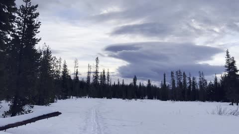
INCREDIBLE Cloud Formation in an Alpine Wonderland! – Ray Benson Sno-Park – Central Oregon – 4K
My goal of these wilderness trail videos is to 1) show reverence for the beauty of the land, and 2) give YOU actionable trail information that can assist you in planning your own hike here.
This was a day-hike in Central Oregon, Willamette National Forest, Ray Benson Sno Park, hiking South Loop by Hayrick Butte and Claypool Butte to Brandeberg Butte and Brandenberg Rustic Log Cabin Shelter, approximately 5.8 miles and 350 FT Elevation Gain. With some other Ray Benson Sno-Park Exploration and hiking Claypool Butte I do more like 7 miles and 500 FT Elevation Gain. ***A WORD OF CAUTION - I WOULD NOT RECOMMEND TAKING THE ALLTRAILS ROUTE OF A LOLLIPOP - once you get to Brandenberg Shelter, I would recommend turning around and backtracking making it an Out and Back. That may seem counterintuitive since you are immediately going back uphill, however that is still less exertion than the next two miles on the Lollipop Loop to connect back to the Stick so to speak since it is not a well defined grooved or packed down trail! That two miles was the hardest of the whole hike, had to break trail and use GPS to track the way through the forest since the path wasn't at all evident. There also aren't really any good views in that section, mostly just meadows and thick forest, so I would highly recommend skipping that and going back up Brandenberg Butte so you get the Mountain Views again and stay on a more trackable path.*** Snowshoes in my humble opinion are a must, I would not attempt this is Yaktrax because several sections are just too thick of snow to not be postholing for miles. This was the warmest day in a long time, low of 31 around Sunrise when I got there with a high of 43, however it did likely sprinkle for hours combined with the winds made this a particularly wet and cold hike given the weather profile going in. This was hiked on 1/13/2023, yes Friday the 13th!, and there were of NO Mosquitoes. As far as road conditions, it's highway and well paved roads until the turnoff for Ray Benson Sno-Park, the last couple tenths although on a well defined road were actually pretty slippery and icy, and the giant parking lot was also a sheet of ice. In my opinion, the road DOES NOT require 4-Wheel Drive, however do watch for road conditions, particularly snow/ice depending on the time of year and drive VERY CAUTIOUSLY.
44
views
2
comments
Ascending EXPOSED BOULDER SECTION of SUMMIT TRAIL! – Mount Hood – Oregon – 4K
My goal of these wilderness trail videos is to 1) show reverence for the beauty of the land, and 2) give YOU actionable trail information that can assist you in planning your own hike here.
This was a day-hike in Oregon, Mount Hood National Forest, Mirror Lake Trailhead, hiking up to Mirror Lake, circumnavigating the lake, and continuing on to the Summit of Tom Dick & Harry Mountain, approximately 9.2 miles and 1700 FT Elevation Gain. The Summit is 4997 FT, pretty low for wilderness standards, so this entire hike is in the subalpine zone, short of the 5000 FT Alpine Zone by 3 FT! It was a sheet of ice on much of the trail, so Yaktrax or Microspikes required as far as I'm concerned, and the sky was mostly blue and clear. This was hiked on 11/24/2022 (Thanksgiving!) and there were of NO Mosquitoes. As far as road conditions, it's highway and well paved roads until the parking lot, so it was a very easy and safe driving route. In my opinion, the road most definitely DOES NOT require 4-Wheel Drive, however do watch for road conditions, particularly snow/ice depending on the time of year.
39
views
4
comments
Mount Hood Summit in WINDY Peace & Serenity! – Mount Hood – Oregon – 4K
My goal of these wilderness trail videos is to 1) show reverence for the beauty of the land, and 2) give YOU actionable trail information that can assist you in planning your own hike here.
This was a day-hike in Oregon, Mount Hood National Forest, Mirror Lake Trailhead, hiking up to Mirror Lake, circumnavigating the lake, and continuing on to the Summit of Tom Dick & Harry Mountain, approximately 9.2 miles and 1700 FT Elevation Gain. The Summit is 4997 FT, pretty low for wilderness standards, so this entire hike is in the subalpine zone, short of the 5000 FT Alpine Zone by 3 FT! It was a sheet of ice on much of the trail, so Yaktrax or Microspikes required as far as I'm concerned, and the sky was mostly blue and clear. This was hiked on 11/24/2022 (Thanksgiving!) and there were of NO Mosquitoes. As far as road conditions, it's highway and well paved roads until the parking lot, so it was a very easy and safe driving route. In my opinion, the road most definitely DOES NOT require 4-Wheel Drive, however do watch for road conditions, particularly snow/ice depending on the time of year.
21
views
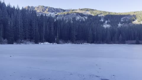
SHADOW and LIGHT on BEAUTIFUL FROZEN Mirror Lake! – Mount Hood – Oregon – 4K
My goal of these wilderness trail videos is to 1) show reverence for the beauty of the land, and 2) give YOU actionable trail information that can assist you in planning your own hike here.
This was a day-hike in Oregon, Mount Hood National Forest, Mirror Lake Trailhead, hiking up to Mirror Lake, circumnavigating the lake, and continuing on to the Summit of Tom Dick & Harry Mountain, approximately 9.2 miles and 1700 FT Elevation Gain. The Summit is 4997 FT, pretty low for wilderness standards, so this entire hike is in the subalpine zone, short of the 5000 FT Alpine Zone by 3 FT! It was a sheet of ice on much of the trail, so Yaktrax or Microspikes required as far as I'm concerned, and the sky was mostly blue and clear. This was hiked on 11/24/2022 (Thanksgiving!) and there were of NO Mosquitoes. As far as road conditions, it's highway and well paved roads until the parking lot, so it was a very easy and safe driving route. In my opinion, the road most definitely DOES NOT require 4-Wheel Drive, however do watch for road conditions, particularly snow/ice depending on the time of year.
13
views

Ascending the Snowy Summit Trail of Tom, Dick & Harry Mountain – Oregon – 4K
My goal of these wilderness trail videos is to 1) show reverence for the beauty of the land, and 2) give YOU actionable trail information that can assist you in planning your own hike here.
This was a day-hike in Oregon, Mount Hood National Forest, Mirror Lake Trailhead, hiking up to Mirror Lake, circumnavigating the lake, and continuing on to the Summit of Tom Dick & Harry Mountain, approximately 9.2 miles and 1700 FT Elevation Gain. The Summit is 4997 FT, pretty low for wilderness standards, so this entire hike is in the subalpine zone, short of the 5000 FT Alpine Zone by 3 FT! It was a sheet of ice on much of the trail, so Yaktrax or Microspikes required as far as I'm concerned, and the sky was mostly blue and clear. This was hiked on 11/24/2022 (Thanksgiving!) and there were of NO Mosquitoes. As far as road conditions, it's highway and well paved roads until the parking lot, so it was a very easy and safe driving route. In my opinion, the road most definitely DOES NOT require 4-Wheel Drive, however do watch for road conditions, particularly snow/ice depending on the time of year.
19
views

EPIC APPROACH to the INCREDIBLE MONEYSHOT of FROZEN Mirror Lake! – Mount Hood – Oregon – 4K
My goal of these wilderness trail videos is to 1) show reverence for the beauty of the land, and 2) give YOU actionable trail information that can assist you in planning your own hike here.
This was a day-hike in Oregon, Mount Hood National Forest, Mirror Lake Trailhead, hiking up to Mirror Lake, circumnavigating the lake, and continuing on to the Summit of Tom Dick & Harry Mountain, approximately 9.2 miles and 1700 FT Elevation Gain. The Summit is 4997 FT, pretty low for wilderness standards, so this entire hike is in the subalpine zone, short of the 5000 FT Alpine Zone by 3 FT! It was a sheet of ice on much of the trail, so Yaktrax or Microspikes required as far as I'm concerned, and the sky was mostly blue and clear. This was hiked on 11/24/2022 (Thanksgiving!) and there were of NO Mosquitoes. As far as road conditions, it's highway and well paved roads until the parking lot, so it was a very easy and safe driving route. In my opinion, the road most definitely DOES NOT require 4-Wheel Drive, however do watch for road conditions, particularly snow/ice depending on the time of year.
29
views
2
comments
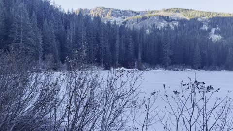
Arriving at the SHORELINE of FROZEN Mirror Lake! – Mount Hood – Oregon – 4K
My goal of these wilderness trail videos is to 1) show reverence for the beauty of the land, and 2) give YOU actionable trail information that can assist you in planning your own hike here.
This was a day-hike in Oregon, Mount Hood National Forest, Mirror Lake Trailhead, hiking up to Mirror Lake, circumnavigating the lake, and continuing on to the Summit of Tom Dick & Harry Mountain, approximately 9.2 miles and 1700 FT Elevation Gain. The Summit is 4997 FT, pretty low for wilderness standards, so this entire hike is in the subalpine zone, short of the 5000 FT Alpine Zone by 3 FT! It was a sheet of ice on much of the trail, so Yaktrax or Microspikes required as far as I'm concerned, and the sky was mostly blue and clear. This was hiked on 11/24/2022 (Thanksgiving!) and there were of NO Mosquitoes. As far as road conditions, it's highway and well paved roads until the parking lot, so it was a very easy and safe driving route. In my opinion, the road most definitely DOES NOT require 4-Wheel Drive, however do watch for road conditions, particularly snow/ice depending on the time of year.
18
views
2
comments
EPIC VIEWS of FROZEN Mirror Lake Framing GLOWING WHITE Mount Hood! – Oregon – 4K
My goal of these wilderness trail videos is to 1) show reverence for the beauty of the land, and 2) give YOU actionable trail information that can assist you in planning your own hike here.
This was a day-hike in Oregon, Mount Hood National Forest, Mirror Lake Trailhead, hiking up to Mirror Lake, circumnavigating the lake, and continuing on to the Summit of Tom Dick & Harry Mountain, approximately 9.2 miles and 1700 FT Elevation Gain. The Summit is 4997 FT, pretty low for wilderness standards, so this entire hike is in the subalpine zone, short of the 5000 FT Alpine Zone by 3 FT! It was a sheet of ice on much of the trail, so Yaktrax or Microspikes required as far as I'm concerned, and the sky was mostly blue and clear. This was hiked on 11/24/2022 (Thanksgiving!) and there were of NO Mosquitoes. As far as road conditions, it's highway and well paved roads until the parking lot, so it was a very easy and safe driving route. In my opinion, the road most definitely DOES NOT require 4-Wheel Drive, however do watch for road conditions, particularly snow/ice depending on the time of year.
27
views
6
comments
Looking Across at Mount Hood from the Summit of Tom, Dick & Harry Mountain! – Oregon – 4K
My goal of these wilderness trail videos is to 1) show reverence for the beauty of the land, and 2) give YOU actionable trail information that can assist you in planning your own hike here.
This was a day-hike in Oregon, Mount Hood National Forest, Mirror Lake Trailhead, hiking up to Mirror Lake, circumnavigating the lake, and continuing on to the Summit of Tom Dick & Harry Mountain, approximately 9.2 miles and 1700 FT Elevation Gain. The Summit is 4997 FT, pretty low for wilderness standards, so this entire hike is in the subalpine zone, short of the 5000 FT Alpine Zone by 3 FT! It was a sheet of ice on much of the trail, so Yaktrax or Microspikes required as far as I'm concerned, and the sky was mostly blue and clear. This was hiked on 11/24/2022 (Thanksgiving!) and there were of NO Mosquitoes. As far as road conditions, it's highway and well paved roads until the parking lot, so it was a very easy and safe driving route. In my opinion, the road most definitely DOES NOT require 4-Wheel Drive, however do watch for road conditions, particularly snow/ice depending on the time of year.
19
views
2
comments
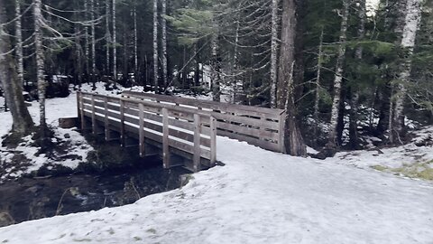
CROSSING TEN BRIDGES! – Mirror Lake & Tom, Dick & Harry Mountain – Mount Hood – Oregon – 4K
My goal of these wilderness trail videos is to 1) show reverence for the beauty of the land, and 2) give YOU actionable trail information that can assist you in planning your own hike here.
This was a day-hike in Oregon, Mount Hood National Forest, Mirror Lake Trailhead, hiking up to Mirror Lake, circumnavigating the lake, and continuing on to the Summit of Tom Dick & Harry Mountain, approximately 9.2 miles and 1700 FT Elevation Gain. The Summit is 4997 FT, pretty low for wilderness standards, so this entire hike is in the subalpine zone, short of the 5000 FT Alpine Zone by 3 FT! It was a sheet of ice on much of the trail, so Yaktrax or Microspikes required as far as I'm concerned, and the sky was mostly blue and clear. This was hiked on 11/24/2022 (Thanksgiving!) and there were of NO Mosquitoes. As far as road conditions, it's highway and well paved roads until the parking lot, so it was a very easy and safe driving route. In my opinion, the road most definitely DOES NOT require 4-Wheel Drive, however do watch for road conditions, particularly snow/ice depending on the time of year.
27
views
3
comments
ASCENDING TO THE SUMMIT of Tom, Dick & Harry Mountain! – Mirror Lake – Mount Hood – Oregon – 4K
My goal of these wilderness trail videos is to 1) show reverence for the beauty of the land, and 2) give YOU actionable trail information that can assist you in planning your own hike here.
This was a day-hike in Oregon, Mount Hood National Forest, Mirror Lake Trailhead, hiking up to Mirror Lake, circumnavigating the lake, and continuing on to the Summit of Tom Dick & Harry Mountain, approximately 9.2 miles and 1700 FT Elevation Gain. The Summit is 4997 FT, pretty low for wilderness standards, so this entire hike is in the subalpine zone, short of the 5000 FT Alpine Zone by 3 FT! It was a sheet of ice on much of the trail, so Yaktrax or Microspikes required as far as I'm concerned, and the sky was mostly blue and clear. This was hiked on 11/24/2022 (Thanksgiving!) and there were of NO Mosquitoes. As far as road conditions, it's highway and well paved roads until the parking lot, so it was a very easy and safe driving route. In my opinion, the road most definitely DOES NOT require 4-Wheel Drive, however do watch for road conditions, particularly snow/ice depending on the time of year.
37
views
9
comments
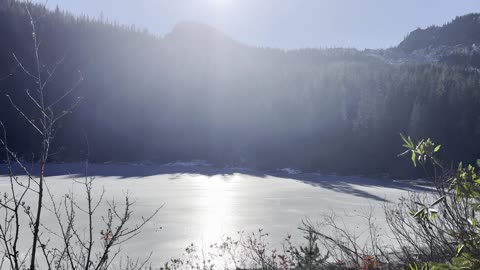
SAFETY TIP: NEVER EVER Walk on a Frozen Lake Unless You Are ABSOLUTELY SURE It Is Safe!
My goal of these wilderness trail videos is to 1) show reverence for the beauty of the land, and 2) give YOU actionable trail information that can assist you in planning your own hike here.
This was a day-hike in Oregon, Mount Hood National Forest, Mirror Lake Trailhead, hiking up to Mirror Lake, circumnavigating the lake, and continuing on to the Summit of Tom Dick & Harry Mountain, approximately 9.2 miles and 1700 FT Elevation Gain. The Summit is 4997 FT, pretty low for wilderness standards, so this entire hike is in the subalpine zone, short of the 5000 FT Alpine Zone by 3 FT! It was a sheet of ice on much of the trail, so Yaktrax or Microspikes required as far as I'm concerned, and the sky was mostly blue and clear. This was hiked on 11/24/2022 (Thanksgiving!) and there were of NO Mosquitoes. As far as road conditions, it's highway and well paved roads until the parking lot, so it was a very easy and safe driving route. In my opinion, the road most definitely DOES NOT require 4-Wheel Drive, however do watch for road conditions, particularly snow/ice depending on the time of year.
28
views
8
comments
Happy Thanksgiving from Tom, Dick & Harry Mountain Summit Trail! – Mount Hood – Oregon – 4K
My goal of these wilderness trail videos is to 1) show reverence for the beauty of the land, and 2) give YOU actionable trail information that can assist you in planning your own hike here.
This was a day-hike in Oregon, Mount Hood National Forest, Mirror Lake Trailhead, hiking up to Mirror Lake, circumnavigating the lake, and continuing on to the Summit of Tom Dick & Harry Mountain, approximately 9.2 miles and 1700 FT Elevation Gain. The Summit is 4997 FT, pretty low for wilderness standards, so this entire hike is in the subalpine zone, short of the 5000 FT Alpine Zone by 3 FT! It was a sheet of ice on much of the trail, so Yaktrax or Microspikes required as far as I'm concerned, and the sky was mostly blue and clear. This was hiked on 11/24/2022 (Thanksgiving!) and there were of NO Mosquitoes. As far as road conditions, it's highway and well paved roads until the parking lot, so it was a very easy and safe driving route. In my opinion, the road most definitely DOES NOT require 4-Wheel Drive, however do watch for road conditions, particularly snow/ice depending on the time of year.
17
views
4
comments
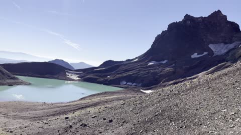
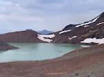
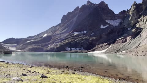
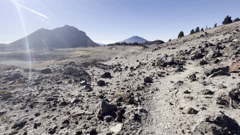
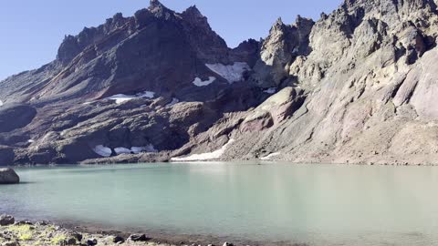
Descending the EPIC Broken Top Alpine Basin – No Name Lake & Broken Top – Central Oregon – 4K
My goal of these wilderness trail videos is to 1) show reverence for the beauty of the land, and 2) give YOU actionable trail information that can assist you in planning your own hike here.
This was a day-hike in Central Oregon, Deschutes National Forest, Three Sisters Wilderness, starting at the Todd Lake Trailhead (recreation.gov permit required), going 14 miles and ascending 2600 FT up to the Broken Top Mountain Zone, No Name Lake, and ultimately Bend Glacier Overlook as our turnaround point for this EPIC Out and Back hike. This is one of my favorite hikes in all of Oregon, featuring my favorite Alpine Cirque Lake (No Name Lake), my favorite mountain (Broken Top), and my favorite Wilderness Area (Three Sisters). The hike starts at 6100 FT and your highest point is around 8200 FT. Due to the elevation range, this hike is only accessible around 10 weeks or so a year give or take based on the annual snowfall, from around 8/1 - 10/15, what I colloquially refer to as the "Alpine Window". I would recommend doing this earlier in the day (starting at sunrise if possible) with fluids on your person because large parts of this hike are FULLY EXPOSED to the SUN. The temperature was high 30's in the morning with a high in the low 70's in the heart of the day. This was hiked on 10/12/2022 and there were no mosquitoes (they are typically gone sometime in September). As far as road conditions, its Cascade Scenic Byway to the turnoff for Todd Lake - that stretch of National Forest Road is very bumpy for a few tenths of a mile to the parking lot. Most cars should be able to make it if they drive slow and cautiously. The road does not in my opinion require 4-Wheel Drive - do watch for road conditions, particularly snow/ice depending on the time of year.
40
views
4
comments
The Peace & Quiet of No Name Lake – 8000' Elevation @ Broken Top – Central Oregon – 4K
My goal of these wilderness trail videos is to 1) show reverence for the beauty of the land, and 2) give YOU actionable trail information that can assist you in planning your own hike here.
This was a day-hike in Central Oregon, Deschutes National Forest, Three Sisters Wilderness, starting at the Todd Lake Trailhead (recreation.gov permit required), going 14 miles and ascending 2600 FT up to the Broken Top Mountain Zone, No Name Lake, and ultimately Bend Glacier Overlook as our turnaround point for this EPIC Out and Back hike. This is one of my favorite hikes in all of Oregon, featuring my favorite Alpine Cirque Lake (No Name Lake), my favorite mountain (Broken Top), and my favorite Wilderness Area (Three Sisters). The hike starts at 6100 FT and your highest point is around 8200 FT. Due to the elevation range, this hike is only accessible around 10 weeks or so a year give or take based on the annual snowfall, from around 8/1 - 10/15, what I colloquially refer to as the "Alpine Window". I would recommend doing this earlier in the day (starting at sunrise if possible) with fluids on your person because large parts of this hike are FULLY EXPOSED to the SUN. The temperature was high 30's in the morning with a high in the low 70's in the heart of the day. This was hiked on 10/12/2022 and there were no mosquitoes (they are typically gone sometime in September). As far as road conditions, its Cascade Scenic Byway to the turnoff for Todd Lake - that stretch of National Forest Road is very bumpy for a few tenths of a mile to the parking lot. Most cars should be able to make it if they drive slow and cautiously. The road does not in my opinion require 4-Wheel Drive - do watch for road conditions, particularly snow/ice depending on the time of year.
27
views
12
comments
Second Creek Crossing + Broken Top – No Name Lake & Broken Top – Central Oregon – 4K
My goal of these wilderness trail videos is to 1) show reverence for the beauty of the land, and 2) give YOU actionable trail information that can assist you in planning your own hike here.
This was a day-hike in Central Oregon, Deschutes National Forest, Three Sisters Wilderness, starting at the Todd Lake Trailhead (recreation.gov permit required), going 14 miles and ascending 2600 FT up to the Broken Top Mountain Zone, No Name Lake, and ultimately Bend Glacier Overlook as our turnaround point for this EPIC Out and Back hike. This is one of my favorite hikes in all of Oregon, featuring my favorite Alpine Cirque Lake (No Name Lake), my favorite mountain (Broken Top), and my favorite Wilderness Area (Three Sisters). The hike starts at 6100 FT and your highest point is around 8200 FT. Due to the elevation range, this hike is only accessible around 10 weeks or so a year give or take based on the annual snowfall, from around 8/1 - 10/15, what I colloquially refer to as the "Alpine Window". I would recommend doing this earlier in the day (starting at sunrise if possible) with fluids on your person because large parts of this hike are FULLY EXPOSED to the SUN. The temperature was high 30's in the morning with a high in the low 70's in the heart of the day. This was hiked on 10/12/2022 and there were no mosquitoes (they are typically gone sometime in September). As far as road conditions, its Cascade Scenic Byway to the turnoff for Todd Lake - that stretch of National Forest Road is very bumpy for a few tenths of a mile to the parking lot. Most cars should be able to make it if they drive slow and cautiously. The road does not in my opinion require 4-Wheel Drive - do watch for road conditions, particularly snow/ice depending on the time of year.
10
views
2
comments
Descending into a Magical Alpine Wonderland – No Name Lake & Broken Top – Central Oregon – 4K
My goal of these wilderness trail videos is to 1) show reverence for the beauty of the land, and 2) give YOU actionable trail information that can assist you in planning your own hike here.
This was a day-hike in Central Oregon, Deschutes National Forest, Three Sisters Wilderness, starting at the Todd Lake Trailhead (recreation.gov permit required), going 14 miles and ascending 2600 FT up to the Broken Top Mountain Zone, No Name Lake, and ultimately Bend Glacier Overlook as our turnaround point for this EPIC Out and Back hike. This is one of my favorite hikes in all of Oregon, featuring my favorite Alpine Cirque Lake (No Name Lake), my favorite mountain (Broken Top), and my favorite Wilderness Area (Three Sisters). The hike starts at 6100 FT and your highest point is around 8200 FT. Due to the elevation range, this hike is only accessible around 10 weeks or so a year give or take based on the annual snowfall, from around 8/1 - 10/15, what I colloquially refer to as the "Alpine Window". I would recommend doing this earlier in the day (starting at sunrise if possible) with fluids on your person because large parts of this hike are FULLY EXPOSED to the SUN. The temperature was high 30's in the morning with a high in the low 70's in the heart of the day. This was hiked on 10/12/2022 and there were no mosquitoes (they are typically gone sometime in September). As far as road conditions, its Cascade Scenic Byway to the turnoff for Todd Lake - that stretch of National Forest Road is very bumpy for a few tenths of a mile to the parking lot. Most cars should be able to make it if they drive slow and cautiously. The road does not in my opinion require 4-Wheel Drive - do watch for road conditions, particularly snow/ice depending on the time of year.
7
views
2
comments
Exploring the Immaculate Alpine Tundra – No Name Lake & Broken Top – Central Oregon – 4K
My goal of these wilderness trail videos is to 1) show reverence for the beauty of the land, and 2) give YOU actionable trail information that can assist you in planning your own hike here.
This was a day-hike in Central Oregon, Deschutes National Forest, Three Sisters Wilderness, starting at the Todd Lake Trailhead (recreation.gov permit required), going 14 miles and ascending 2600 FT up to the Broken Top Mountain Zone, No Name Lake, and ultimately Bend Glacier Overlook as our turnaround point for this EPIC Out and Back hike. This is one of my favorite hikes in all of Oregon, featuring my favorite Alpine Cirque Lake (No Name Lake), my favorite mountain (Broken Top), and my favorite Wilderness Area (Three Sisters). The hike starts at 6100 FT and your highest point is around 8200 FT. Due to the elevation range, this hike is only accessible around 10 weeks or so a year give or take based on the annual snowfall, from around 8/1 - 10/15, what I colloquially refer to as the "Alpine Window". I would recommend doing this earlier in the day (starting at sunrise if possible) with fluids on your person because large parts of this hike are FULLY EXPOSED to the SUN. The temperature was high 30's in the morning with a high in the low 70's in the heart of the day. This was hiked on 10/12/2022 and there were no mosquitoes (they are typically gone sometime in September). As far as road conditions, its Cascade Scenic Byway to the turnoff for Todd Lake - that stretch of National Forest Road is very bumpy for a few tenths of a mile to the parking lot. Most cars should be able to make it if they drive slow and cautiously. The road does not in my opinion require 4-Wheel Drive - do watch for road conditions, particularly snow/ice depending on the time of year.
6
views
THIS IS Beauty Personified – No Name Lake & Broken Top – Central Oregon – 4K
My goal of these wilderness trail videos is to 1) show reverence for the beauty of the land, and 2) give YOU actionable trail information that can assist you in planning your own hike here.
This was a day-hike in Central Oregon, Deschutes National Forest, Three Sisters Wilderness, starting at the Todd Lake Trailhead (recreation.gov permit required), going 14 miles and ascending 2600 FT up to the Broken Top Mountain Zone, No Name Lake, and ultimately Bend Glacier Overlook as our turnaround point for this EPIC Out and Back hike. This is one of my favorite hikes in all of Oregon, featuring my favorite Alpine Cirque Lake (No Name Lake), my favorite mountain (Broken Top), and my favorite Wilderness Area (Three Sisters). The hike starts at 6100 FT and your highest point is around 8200 FT. Due to the elevation range, this hike is only accessible around 10 weeks or so a year give or take based on the annual snowfall, from around 8/1 - 10/15, what I colloquially refer to as the "Alpine Window". I would recommend doing this earlier in the day (starting at sunrise if possible) with fluids on your person because large parts of this hike are FULLY EXPOSED to the SUN. The temperature was high 30's in the morning with a high in the low 70's in the heart of the day. This was hiked on 10/12/2022 and there were no mosquitoes (they are typically gone sometime in September). As far as road conditions, its Cascade Scenic Byway to the turnoff for Todd Lake - that stretch of National Forest Road is very bumpy for a few tenths of a mile to the parking lot. Most cars should be able to make it if they drive slow and cautiously. The road does not in my opinion require 4-Wheel Drive - do watch for road conditions, particularly snow/ice depending on the time of year.
16
views
2
comments