
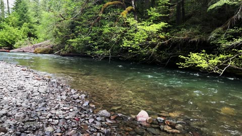
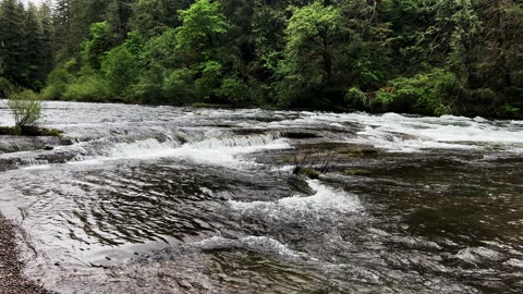
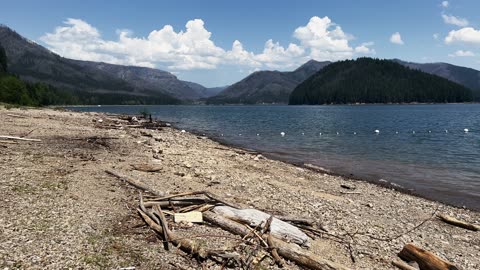
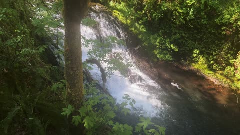
2+ MINUTES OF SOOTHING SILENCE! | House Rock Campground @ South Santiam River! | Central Oregon | 4K
A silent collection of sections of South Santiam River at House Rock Campground, Willamette National Forest, Central Oregon in 4K! This video was made on 5/21/23. Mosquitoes were non-existent.
*Please note - there is a separate silent collection of sections of House Rock Falls video as well.
28
views
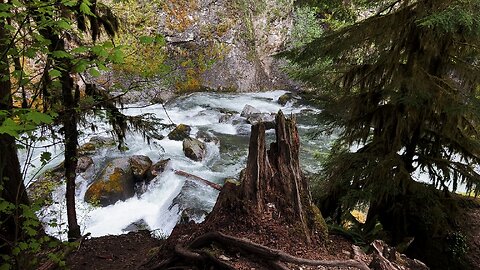
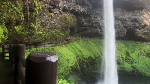
SOOTHING SILENCE & TRANQUILITY | GORGEOUS House Rock Falls! | South Santiam River | Oregon | 4K
A silent video of sections of INCREDIBLE House Rock Falls, flowing into South Santiam River, near House Rock Campground, Willamette National Forest, Central Oregon, in 4K! This video was made on 5/21/23. Mosquitoes were non-existent.
*Please note - there is a separate silent video of sections of House Rock Campground and a full hiking video of Santiam Wagon Trail exploring House Rock.
29
views
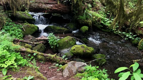
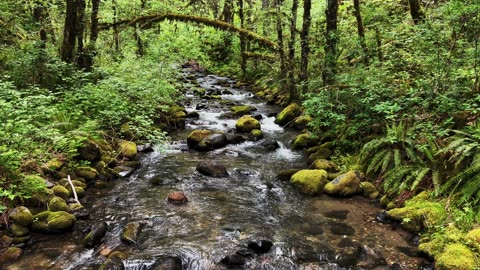
SOOTHING SILENCE & PEACEFUL TRANQUILITY | Perspectives of Soda Creek @ Cascadia Park | Oregon | 4K
A silent collection of different perspectives of the peaceful, serene, and beautiful Soda Creek in Cascadia County Park (formerly State), Central Oregon in 4K! This video was made on 5/20/23. Mosquitoes were non-existent.
21
views
SOOTHING SILENCE & PEACEFUL TRANQUILITY | Soda Springs Trail @ Cascadia Park | Oregon | 4K
A silent collection of different perspectives of the peaceful, serene, and beautiful Soda Springs Trail in Cascadia County Park (formerly State), Central Oregon in 4K! This video was made on 5/20/23. Mosquitoes were non-existent.
30
views
SOOTHING PEACEFUL SILENCE @ Trout Creek in the Menagerie Wilderness! | Central Oregon | 4K
The bridge view in silence of Trout Creek on the border of the Menagerie Wilderness, Central Oregon in 4K! This video was made on 5/21/23. Mosquitoes were non-existent.
27
views
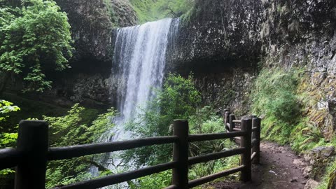
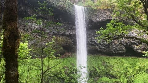
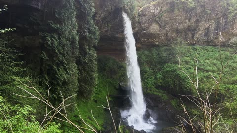
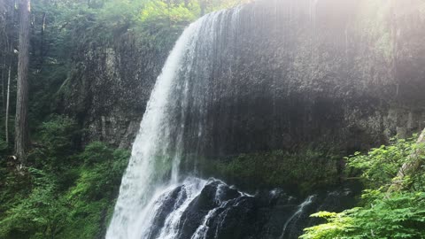
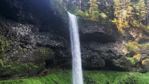
EXPLORING THE EPIC South Waterfall! | Trail of Ten Falls | Silver Falls State Park | Oregon | 4K
This was a 7.4 mile, 1200 FT Elevation Gain Loop Hike of the ABSOLUTELY INCREDIBLE Trail of Ten Falls, Silver Falls State Park, Oregon, in 4K! This is unquestionably the BEST WATERFALL HIKE IN OREGON, and a TOP 5 WATERFALL HIKE IN THE ENTIRE USA, so it is truly EPIC and absolutely worth putting on your bucket list to experience. They almost designated this a National Park many years ago (I'm glad they didn't for logistical reasons), it is truly a natural beauty wonderland to behold. This was hiked on 5/20/23, the weather was classic Spring in Oregon with some sunshine and overcast, and there were no mosquitoes.
I hiked the Loop Clockwise and would recommend the same route. The Ten Waterfalls in order hiking Clockwise are:
1) South Falls - 177 FT (can walk behind!) (hiking beside South Fork Silver Creek)
2) Lower South Falls - 93 FT (can walk behind!) (hiking beside South Fork Silver Creek)
3) Lower North Falls - 30 FT (hiking beside North Fork Silver Creek)
4) Double Falls - 178 FT (hiking beside North Fork Silver Creek)
5) Drake Falls - 27 FT (hiking beside North Fork Silver Creek)
6) Middle North Falls - 106 FT (can walk behind!) (hiking beside North Fork Silver Creek)
7) Twin Falls - 31 FT (hiking beside North Fork Silver Creek)
8) North Falls - 136 FT (can walk behind!) (hiking beside North Fork Silver Creek)
9) Upper North Falls - 65 FT
10) Winter Falls - 134 FT
My favorites were the four you could walk behind, not just for that reason but they were also the most beautiful Waterfall Basins and most awe-inspiring overall. All Ten Waterfalls are very high quality and each one could be a destination hike on its own, so for them to be put together all in one EPIC Sensory Overload Waterfall Loop Hike is truly spectacular!
78
views
2
comments
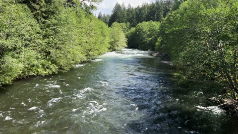
GORGEOUS & RAGING North Santiam River from the SE Bridge Circumnavigating Detroit Lake | Oregon | 4K
While circumnavigating Detroit Lake & State Park, there is a bridge crossing in the SE Quadrant - this is the perspective if you get out of your car and look at the North Santiam River in both directions. This was done on 5/20/23, a week BEFORE the official start of the Summer Camping Season.
74
views
2
comments

PEACE & TRANQUILITY @ Cove Creek Campground Beach Area & Boat Ramp/Dock @ Detroit Lake | Oregon | 4K
Exploring the shoreline of Cove Creek Campground & Boat Ramp/Dock at Detroit Lake State Park on 5/20/23, a week BEFORE the official start of the Summer Camping Season.
56
views

SPECTACULAR OVERLOOK PERSPECTIVE of Detroit Dam to the WEST & Detroit Lake to the EAST | Oregon | 4K
Magnificent Views Overlooking Detroit Dam to the WEST & Detroit Lake State Park to the EAST, on 5/20/23, a week BEFORE the official start of the Summer Camping Season.
83
views
2
comments
SERENE SILENCE & BEAUTY @ Mongold Day Use Beach Area & Boat Ramp/Dock @ Detroit Lake | Oregon | 4K
Exploring the Mongold Day Use Beach & Boat Ramp/Dock at Detroit Lake State Park on 5/20/23, a week BEFORE the official start of the Summer Camping Season.
91
views
4
comments
Hiking Exploring Lower South Waterfall! | Trail of Ten Falls | Silver Falls State Park | Oregon | 4K
This was a 7.4 mile, 1200 FT Elevation Gain Loop Hike of the ABSOLUTELY INCREDIBLE Trail of Ten Falls, Silver Falls State Park, Oregon, in 4K! This is unquestionably the BEST WATERFALL HIKE IN OREGON, and a TOP 5 WATERFALL HIKE IN THE ENTIRE USA, so it is truly EPIC and absolutely worth putting on your bucket list to experience. They almost designated this a National Park many years ago (I'm glad they didn't for logistical reasons), it is truly a natural beauty wonderland to behold. This was hiked on 5/20/23, the weather was classic Spring in Oregon with some sunshine and overcast, and there were no mosquitoes.
I hiked the Loop Clockwise and would recommend the same route. The Ten Waterfalls in order hiking Clockwise are:
1) South Falls - 177 FT (can walk behind!) (hiking beside South Fork Silver Creek)
2) Lower South Falls - 93 FT (can walk behind!) (hiking beside South Fork Silver Creek)
3) Lower North Falls - 30 FT (hiking beside North Fork Silver Creek)
4) Double Falls - 178 FT (hiking beside North Fork Silver Creek)
5) Drake Falls - 27 FT (hiking beside North Fork Silver Creek)
6) Middle North Falls - 106 FT (can walk behind!) (hiking beside North Fork Silver Creek)
7) Twin Falls - 31 FT (hiking beside North Fork Silver Creek)
8) North Falls - 136 FT (can walk behind!) (hiking beside North Fork Silver Creek)
9) Upper North Falls - 65 FT
10) Winter Falls - 134 FT
My favorites were the four you could walk behind, not just for that reason but they were also the most beautiful Waterfall Basins and most awe-inspiring overall. All Ten Waterfalls are very high quality and each one could be a destination hike on its own, so for them to be put together all in one EPIC Sensory Overload Waterfall Loop Hike is truly spectacular!
156
views
4
comments

Hiking Exploring Lower North Waterfall! | Trail of Ten Falls | Silver Falls State Park | Oregon | 4K
This was a 7.4 mile, 1200 FT Elevation Gain Loop Hike of the ABSOLUTELY INCREDIBLE Trail of Ten Falls, Silver Falls State Park, Oregon, in 4K! This is unquestionably the BEST WATERFALL HIKE IN OREGON, and a TOP 5 WATERFALL HIKE IN THE ENTIRE USA, so it is truly EPIC and absolutely worth putting on your bucket list to experience. They almost designated this a National Park many years ago (I'm glad they didn't for logistical reasons), it is truly a natural beauty wonderland to behold. This was hiked on 5/20/23, the weather was classic Spring in Oregon with some sunshine and overcast, and there were no mosquitoes.
I hiked the Loop Clockwise and would recommend the same route. The Ten Waterfalls in order hiking Clockwise are:
1) South Falls - 177 FT (can walk behind!) (hiking beside South Fork Silver Creek)
2) Lower South Falls - 93 FT (can walk behind!) (hiking beside South Fork Silver Creek)
3) Lower North Falls - 30 FT (hiking beside North Fork Silver Creek)
4) Double Falls - 178 FT (hiking beside North Fork Silver Creek)
5) Drake Falls - 27 FT (hiking beside North Fork Silver Creek)
6) Middle North Falls - 106 FT (can walk behind!) (hiking beside North Fork Silver Creek)
7) Twin Falls - 31 FT (hiking beside North Fork Silver Creek)
8) North Falls - 136 FT (can walk behind!) (hiking beside North Fork Silver Creek)
9) Upper North Falls - 65 FT
10) Winter Falls - 134 FT
My favorites were the four you could walk behind, not just for that reason but they were also the most beautiful Waterfall Basins and most awe-inspiring overall. All Ten Waterfalls are very high quality and each one could be a destination hike on its own, so for them to be put together all in one EPIC Sensory Overload Waterfall Loop Hike is truly spectacular!
123
views
2
comments
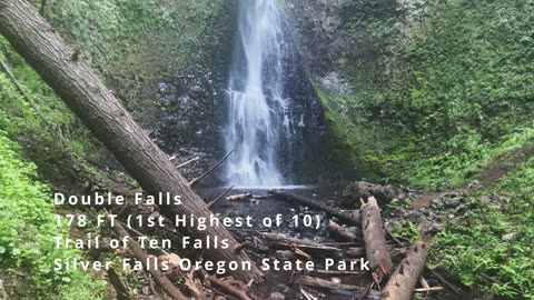
HEIGHT GRAND CHAMPION Double Waterfall! | Trail of Ten Falls | Silver Falls State Park | Oregon | 4K
This was a 7.4 mile, 1200 FT Elevation Gain Loop Hike of the ABSOLUTELY INCREDIBLE Trail of Ten Falls, Silver Falls State Park, Oregon, in 4K! This is unquestionably the BEST WATERFALL HIKE IN OREGON, and a TOP 5 WATERFALL HIKE IN THE ENTIRE USA, so it is truly EPIC and absolutely worth putting on your bucket list to experience. They almost designated this a National Park many years ago (I'm glad they didn't for logistical reasons), it is truly a natural beauty wonderland to behold. This was hiked on 5/20/23, the weather was classic Spring in Oregon with some sunshine and overcast, and there were no mosquitoes.
I hiked the Loop Clockwise and would recommend the same route. The Ten Waterfalls in order hiking Clockwise are:
1) South Falls - 177 FT (can walk behind!) (hiking beside South Fork Silver Creek)
2) Lower South Falls - 93 FT (can walk behind!) (hiking beside South Fork Silver Creek)
3) Lower North Falls - 30 FT (hiking beside North Fork Silver Creek)
4) Double Falls - 178 FT (hiking beside North Fork Silver Creek)
5) Drake Falls - 27 FT (hiking beside North Fork Silver Creek)
6) Middle North Falls - 106 FT (can walk behind!) (hiking beside North Fork Silver Creek)
7) Twin Falls - 31 FT (hiking beside North Fork Silver Creek)
8) North Falls - 136 FT (can walk behind!) (hiking beside North Fork Silver Creek)
9) Upper North Falls - 65 FT
10) Winter Falls - 134 FT
My favorites were the four you could walk behind, not just for that reason but they were also the most beautiful Waterfall Basins and most awe-inspiring overall. All Ten Waterfalls are very high quality and each one could be a destination hike on its own, so for them to be put together all in one EPIC Sensory Overload Waterfall Loop Hike is truly spectacular!
64
views
4
comments
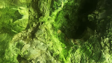
THE CAVE BEHIND Middle North Waterfall! | Trail of Ten Falls | Silver Falls State Park | Oregon | 4K
This was a 7.4 mile, 1200 FT Elevation Gain Loop Hike of the ABSOLUTELY INCREDIBLE Trail of Ten Falls, Silver Falls State Park, Oregon, in 4K! This is unquestionably the BEST WATERFALL HIKE IN OREGON, and a TOP 5 WATERFALL HIKE IN THE ENTIRE USA, so it is truly EPIC and absolutely worth putting on your bucket list to experience. They almost designated this a National Park many years ago (I'm glad they didn't for logistical reasons), it is truly a natural beauty wonderland to behold. This was hiked on 5/20/23, the weather was classic Spring in Oregon with some sunshine and overcast, and there were no mosquitoes.
I hiked the Loop Clockwise and would recommend the same route. The Ten Waterfalls in order hiking Clockwise are:
1) South Falls - 177 FT (can walk behind!) (hiking beside South Fork Silver Creek)
2) Lower South Falls - 93 FT (can walk behind!) (hiking beside South Fork Silver Creek)
3) Lower North Falls - 30 FT (hiking beside North Fork Silver Creek)
4) Double Falls - 178 FT (hiking beside North Fork Silver Creek)
5) Drake Falls - 27 FT (hiking beside North Fork Silver Creek)
6) Middle North Falls - 106 FT (can walk behind!) (hiking beside North Fork Silver Creek)
7) Twin Falls - 31 FT (hiking beside North Fork Silver Creek)
8) North Falls - 136 FT (can walk behind!) (hiking beside North Fork Silver Creek)
9) Upper North Falls - 65 FT
10) Winter Falls - 134 FT
My favorites were the four you could walk behind, not just for that reason but they were also the most beautiful Waterfall Basins and most awe-inspiring overall. All Ten Waterfalls are very high quality and each one could be a destination hike on its own, so for them to be put together all in one EPIC Sensory Overload Waterfall Loop Hike is truly spectacular!
63
views
2
comments
Hiking Approach to Drake Waterfall! | Trail of Ten Falls | Silver Falls State Park | Oregon | 4K
This was a 7.4 mile, 1200 FT Elevation Gain Loop Hike of the ABSOLUTELY INCREDIBLE Trail of Ten Falls, Silver Falls State Park, Oregon, in 4K! This is unquestionably the BEST WATERFALL HIKE IN OREGON, and a TOP 5 WATERFALL HIKE IN THE ENTIRE USA, so it is truly EPIC and absolutely worth putting on your bucket list to experience. They almost designated this a National Park many years ago (I'm glad they didn't for logistical reasons), it is truly a natural beauty wonderland to behold. This was hiked on 5/20/23, the weather was classic Spring in Oregon with some sunshine and overcast, and there were no mosquitoes.
I hiked the Loop Clockwise and would recommend the same route. The Ten Waterfalls in order hiking Clockwise are:
1) South Falls - 177 FT (can walk behind!) (hiking beside South Fork Silver Creek)
2) Lower South Falls - 93 FT (can walk behind!) (hiking beside South Fork Silver Creek)
3) Lower North Falls - 30 FT (hiking beside North Fork Silver Creek)
4) Double Falls - 178 FT (hiking beside North Fork Silver Creek)
5) Drake Falls - 27 FT (hiking beside North Fork Silver Creek)
6) Middle North Falls - 106 FT (can walk behind!) (hiking beside North Fork Silver Creek)
7) Twin Falls - 31 FT (hiking beside North Fork Silver Creek)
8) North Falls - 136 FT (can walk behind!) (hiking beside North Fork Silver Creek)
9) Upper North Falls - 65 FT
10) Winter Falls - 134 FT
My favorites were the four you could walk behind, not just for that reason but they were also the most beautiful Waterfall Basins and most awe-inspiring overall. All Ten Waterfalls are very high quality and each one could be a destination hike on its own, so for them to be put together all in one EPIC Sensory Overload Waterfall Loop Hike is truly spectacular!
92
views
2
comments

I'M THE ONLY HUMAN BEING HERE! @ Southshore Campground & Boat Ramp/Dock @ Detroit Lake | Oregon | 4K
Exploring the Southshore Campground Boat Ramp/Dock at Detroit Lake on 5/20/23, a week BEFORE the official start of the Summer Camping Season. I was the only human being at the Boat Dock & Campground!
165
views
9
comments
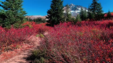
BITE-SIZED WILDS | A Brilliant Cornucopia of Fall Color @ Mount Hood | Timberline Loop | Oregon | 4K
This was a 13.7 mile, 2900 FT Elevation Gain Day-Hike in Oregon, Mount Hood Wilderness, focusing on the SW Quadrant of the approximately 40-mile EPIC Timberline Loop that goes around Mount Hood (one of the two best alpine backpacking hikes in Oregon along with Broken Top Loop), starting at Timberline Lodge Pacific Crest Trailhead, and hiking West towards Little Zig Zag Canyon, Zig Zag Canyon, crossing Zig Zag River and ultimately to Paradise Park and Paradise Branch Falls Lookout as our turnaround point as an out and back Day-Hike. Weather was a low of 34, high of 59, blue sky day and mildly to moderately windy. This was hiked on 10/3/2021 with fall colors in transition or full bloom, trail was completely clear of snow, and there were NO Mosquitoes! On Alltrails, this hike is called "Timberline Trail Around Mount Hood", with a focus on the SW Quadrant. As far as road conditions, it's highway until the turnoff for Timberline Lodge, and a well paved road all the way up the 6 miles to the parking lot. This is as easy and convenient of a trailhead parking as you will ever find. In my opinion, the road most definitely DOES NOT require 4-Wheel Drive. As far as permits, the Timberline Lodge Pacific Crest Trailhead DOES NOT require a Recreation.gov permit.
57
views

BITE-SIZED WILDS | GORGEOUS AUTUMN ALPINE FALL FOLIAGE @ Mount Hood! | Timberline Loop | Oregon | 4K
This was a 13.7 mile, 2900 FT Elevation Gain Day-Hike in Oregon, Mount Hood Wilderness, focusing on the SW Quadrant of the approximately 40-mile EPIC Timberline Loop that goes around Mount Hood (one of the two best alpine backpacking hikes in Oregon along with Broken Top Loop), starting at Timberline Lodge Pacific Crest Trailhead, and hiking West towards Little Zig Zag Canyon, Zig Zag Canyon, crossing Zig Zag River and ultimately to Paradise Park and Paradise Branch Falls Lookout as our turnaround point as an out and back Day-Hike. Weather was a low of 34, high of 59, blue sky day and mildly to moderately windy. This was hiked on 10/3/2021 with fall colors in transition or full bloom, trail was completely clear of snow, and there were NO Mosquitoes! On Alltrails, this hike is called "Timberline Trail Around Mount Hood", with a focus on the SW Quadrant. As far as road conditions, it's highway until the turnoff for Timberline Lodge, and a well paved road all the way up the 6 miles to the parking lot. This is as easy and convenient of a trailhead parking as you will ever find. In my opinion, the road most definitely DOES NOT require 4-Wheel Drive. As far as permits, the Timberline Lodge Pacific Crest Trailhead DOES NOT require a Recreation.gov permit.
42
views

BITE-SIZED WILDS | Glowing Radiant Autumn Fall Foliage @ Mount Hood! | Timberline Loop | Oregon | 4K
This was a 13.7 mile, 2900 FT Elevation Gain Day-Hike in Oregon, Mount Hood Wilderness, focusing on the SW Quadrant of the approximately 40-mile EPIC Timberline Loop that goes around Mount Hood (one of the two best alpine backpacking hikes in Oregon along with Broken Top Loop), starting at Timberline Lodge Pacific Crest Trailhead, and hiking West towards Little Zig Zag Canyon, Zig Zag Canyon, crossing Zig Zag River and ultimately to Paradise Park and Paradise Branch Falls Lookout as our turnaround point as an out and back Day-Hike. Weather was a low of 34, high of 59, blue sky day and mildly to moderately windy. This was hiked on 10/3/2021 with fall colors in transition or full bloom, trail was completely clear of snow, and there were NO Mosquitoes! On Alltrails, this hike is called "Timberline Trail Around Mount Hood", with a focus on the SW Quadrant. As far as road conditions, it's highway until the turnoff for Timberline Lodge, and a well paved road all the way up the 6 miles to the parking lot. This is as easy and convenient of a trailhead parking as you will ever find. In my opinion, the road most definitely DOES NOT require 4-Wheel Drive. As far as permits, the Timberline Lodge Pacific Crest Trailhead DOES NOT require a Recreation.gov permit.
39
views
MAJESTIC & SPECTACULAR South Waterfall! | Trail of Ten Falls | Silver Falls State Park | Oregon | 4K
This was a 7.4 mile, 1200 FT Elevation Gain Loop Hike of the ABSOLUTELY INCREDIBLE Trail of Ten Falls, Silver Falls State Park, Oregon, in 4K! This is unquestionably the BEST WATERFALL HIKE IN OREGON, and a TOP 5 WATERFALL HIKE IN THE ENTIRE USA, so it is truly EPIC and absolutely worth putting on your bucket list to experience. They almost designated this a National Park many years ago (I'm glad they didn't for logistical reasons), it is truly a natural beauty wonderland to behold. This was hiked on 5/20/23, the weather was classic Spring in Oregon with some sunshine and overcast, and there were no mosquitoes.
I hiked the Loop Clockwise and would recommend the same route. The Ten Waterfalls in order hiking Clockwise are:
1) South Falls - 177 FT (can walk behind!) (hiking beside South Fork Silver Creek)
2) Lower South Falls - 93 FT (can walk behind!) (hiking beside South Fork Silver Creek)
3) Lower North Falls - 30 FT (hiking beside North Fork Silver Creek)
4) Double Falls - 178 FT (hiking beside North Fork Silver Creek)
5) Drake Falls - 27 FT (hiking beside North Fork Silver Creek)
6) Middle North Falls - 106 FT (can walk behind!) (hiking beside North Fork Silver Creek)
7) Twin Falls - 31 FT (hiking beside North Fork Silver Creek)
8) North Falls - 136 FT (can walk behind!) (hiking beside North Fork Silver Creek)
9) Upper North Falls - 65 FT
10) Winter Falls - 134 FT
My favorites were the four you could walk behind, not just for that reason but they were also the most beautiful Waterfall Basins and most awe-inspiring overall. All Ten Waterfalls are very high quality and each one could be a destination hike on its own, so for them to be put together all in one EPIC Sensory Overload Waterfall Loop Hike is truly spectacular!
62
views
2
comments
AWE-INSPIRING MAGICAL North Waterfall! | Trail of Ten Falls | Silver Falls State Park | Oregon | 4K
This was a 7.4 mile, 1200 FT Elevation Gain Loop Hike of the ABSOLUTELY INCREDIBLE Trail of Ten Falls, Silver Falls State Park, Oregon, in 4K! This is unquestionably the BEST WATERFALL HIKE IN OREGON, and a TOP 5 WATERFALL HIKE IN THE ENTIRE USA, so it is truly EPIC and absolutely worth putting on your bucket list to experience. They almost designated this a National Park many years ago (I'm glad they didn't for logistical reasons), it is truly a natural beauty wonderland to behold. This was hiked on 5/20/23, the weather was classic Spring in Oregon with some sunshine and overcast, and there were no mosquitoes.
I hiked the Loop Clockwise and would recommend the same route. The Ten Waterfalls in order hiking Clockwise are:
1) South Falls - 177 FT (can walk behind!) (hiking beside South Fork Silver Creek)
2) Lower South Falls - 93 FT (can walk behind!) (hiking beside South Fork Silver Creek)
3) Lower North Falls - 30 FT (hiking beside North Fork Silver Creek)
4) Double Falls - 178 FT (hiking beside North Fork Silver Creek)
5) Drake Falls - 27 FT (hiking beside North Fork Silver Creek)
6) Middle North Falls - 106 FT (can walk behind!) (hiking beside North Fork Silver Creek)
7) Twin Falls - 31 FT (hiking beside North Fork Silver Creek)
8) North Falls - 136 FT (can walk behind!) (hiking beside North Fork Silver Creek)
9) Upper North Falls - 65 FT
10) Winter Falls - 134 FT
My favorites were the four you could walk behind, not just for that reason but they were also the most beautiful Waterfall Basins and most awe-inspiring overall. All Ten Waterfalls are very high quality and each one could be a destination hike on its own, so for them to be put together all in one EPIC Sensory Overload Waterfall Loop Hike is truly spectacular!
40
views
4
comments
GORGEOUS Middle North Waterfall & Basin | Trail of Ten Falls | Silver Falls State Park | Oregon | 4K
This was a 7.4 mile, 1200 FT Elevation Gain Loop Hike of the ABSOLUTELY INCREDIBLE Trail of Ten Falls, Silver Falls State Park, Oregon, in 4K! This is unquestionably the BEST WATERFALL HIKE IN OREGON, and a TOP 5 WATERFALL HIKE IN THE ENTIRE USA, so it is truly EPIC and absolutely worth putting on your bucket list to experience. They almost designated this a National Park many years ago (I'm glad they didn't for logistical reasons), it is truly a natural beauty wonderland to behold. This was hiked on 5/20/23, the weather was classic Spring in Oregon with some sunshine and overcast, and there were no mosquitoes.
I hiked the Loop Clockwise and would recommend the same route. The Ten Waterfalls in order hiking Clockwise are:
1) South Falls - 177 FT (can walk behind!) (hiking beside South Fork Silver Creek)
2) Lower South Falls - 93 FT (can walk behind!) (hiking beside South Fork Silver Creek)
3) Lower North Falls - 30 FT (hiking beside North Fork Silver Creek)
4) Double Falls - 178 FT (hiking beside North Fork Silver Creek)
5) Drake Falls - 27 FT (hiking beside North Fork Silver Creek)
6) Middle North Falls - 106 FT (can walk behind!) (hiking beside North Fork Silver Creek)
7) Twin Falls - 31 FT (hiking beside North Fork Silver Creek)
8) North Falls - 136 FT (can walk behind!) (hiking beside North Fork Silver Creek)
9) Upper North Falls - 65 FT
10) Winter Falls - 134 FT
My favorites were the four you could walk behind, not just for that reason but they were also the most beautiful Waterfall Basins and most awe-inspiring overall. All Ten Waterfalls are very high quality and each one could be a destination hike on its own, so for them to be put together all in one EPIC Sensory Overload Waterfall Loop Hike is truly spectacular!
43
views
2
comments
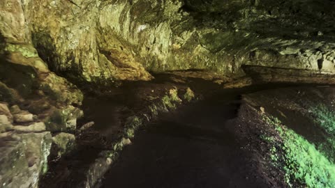
HIKING THE CAVE BEHIND North Waterfall! | Trail of Ten Falls | Silver Falls State Park | Oregon | 4K
This was a 7.4 mile, 1200 FT Elevation Gain Loop Hike of the ABSOLUTELY INCREDIBLE Trail of Ten Falls, Silver Falls State Park, Oregon, in 4K! This is unquestionably the BEST WATERFALL HIKE IN OREGON, and a TOP 5 WATERFALL HIKE IN THE ENTIRE USA, so it is truly EPIC and absolutely worth putting on your bucket list to experience. They almost designated this a National Park many years ago (I'm glad they didn't for logistical reasons), it is truly a natural beauty wonderland to behold. This was hiked on 5/20/23, the weather was classic Spring in Oregon with some sunshine and overcast, and there were no mosquitoes.
I hiked the Loop Clockwise and would recommend the same route. The Ten Waterfalls in order hiking Clockwise are:
1) South Falls - 177 FT (can walk behind!) (hiking beside South Fork Silver Creek)
2) Lower South Falls - 93 FT (can walk behind!) (hiking beside South Fork Silver Creek)
3) Lower North Falls - 30 FT (hiking beside North Fork Silver Creek)
4) Double Falls - 178 FT (hiking beside North Fork Silver Creek)
5) Drake Falls - 27 FT (hiking beside North Fork Silver Creek)
6) Middle North Falls - 106 FT (can walk behind!) (hiking beside North Fork Silver Creek)
7) Twin Falls - 31 FT (hiking beside North Fork Silver Creek)
8) North Falls - 136 FT (can walk behind!) (hiking beside North Fork Silver Creek)
9) Upper North Falls - 65 FT
10) Winter Falls - 134 FT
My favorites were the four you could walk behind, not just for that reason but they were also the most beautiful Waterfall Basins and most awe-inspiring overall. All Ten Waterfalls are very high quality and each one could be a destination hike on its own, so for them to be put together all in one EPIC Sensory Overload Waterfall Loop Hike is truly spectacular!
201
views
6
comments

HIKING BEHIND Middle North Waterfall! | Trail of Ten Falls | Silver Falls State Park | Oregon | 4K
This was a 7.4 mile, 1200 FT Elevation Gain Loop Hike of the ABSOLUTELY INCREDIBLE Trail of Ten Falls, Silver Falls State Park, Oregon, in 4K! This is unquestionably the BEST WATERFALL HIKE IN OREGON, and a TOP 5 WATERFALL HIKE IN THE ENTIRE USA, so it is truly EPIC and absolutely worth putting on your bucket list to experience. They almost designated this a National Park many years ago (I'm glad they didn't for logistical reasons), it is truly a natural beauty wonderland to behold. This was hiked on 5/20/23, the weather was classic Spring in Oregon with some sunshine and overcast, and there were no mosquitoes.
I hiked the Loop Clockwise and would recommend the same route. The Ten Waterfalls in order hiking Clockwise are:
1) South Falls - 177 FT (can walk behind!) (hiking beside South Fork Silver Creek)
2) Lower South Falls - 93 FT (can walk behind!) (hiking beside South Fork Silver Creek)
3) Lower North Falls - 30 FT (hiking beside North Fork Silver Creek)
4) Double Falls - 178 FT (hiking beside North Fork Silver Creek)
5) Drake Falls - 27 FT (hiking beside North Fork Silver Creek)
6) Middle North Falls - 106 FT (can walk behind!) (hiking beside North Fork Silver Creek)
7) Twin Falls - 31 FT (hiking beside North Fork Silver Creek)
8) North Falls - 136 FT (can walk behind!) (hiking beside North Fork Silver Creek)
9) Upper North Falls - 65 FT
10) Winter Falls - 134 FT
My favorites were the four you could walk behind, not just for that reason but they were also the most beautiful Waterfall Basins and most awe-inspiring overall. All Ten Waterfalls are very high quality and each one could be a destination hike on its own, so for them to be put together all in one EPIC Sensory Overload Waterfall Loop Hike is truly spectacular!
161
views
2
comments
EPIC & INCREDIBLE South Waterfall! | Trail of Ten Falls | Silver Falls State Park | Oregon | 4K
This was a 7.4 mile, 1200 FT Elevation Gain Loop Hike of the ABSOLUTELY INCREDIBLE Trail of Ten Falls, Silver Falls State Park, Oregon, in 4K! This is unquestionably the BEST WATERFALL HIKE IN OREGON, and a TOP 5 WATERFALL HIKE IN THE ENTIRE USA, so it is truly EPIC and absolutely worth putting on your bucket list to experience. They almost designated this a National Park many years ago (I'm glad they didn't for logistical reasons), it is truly a natural beauty wonderland to behold. This was hiked on 5/20/23, the weather was classic Spring in Oregon with some sunshine and overcast, and there were no mosquitoes.
I hiked the Loop Clockwise and would recommend the same route. The Ten Waterfalls in order hiking Clockwise are:
1) South Falls - 177 FT (can walk behind!) (hiking beside South Fork Silver Creek)
2) Lower South Falls - 93 FT (can walk behind!) (hiking beside South Fork Silver Creek)
3) Lower North Falls - 30 FT (hiking beside North Fork Silver Creek)
4) Double Falls - 178 FT (hiking beside North Fork Silver Creek)
5) Drake Falls - 27 FT (hiking beside North Fork Silver Creek)
6) Middle North Falls - 106 FT (can walk behind!) (hiking beside North Fork Silver Creek)
7) Twin Falls - 31 FT (hiking beside North Fork Silver Creek)
8) North Falls - 136 FT (can walk behind!) (hiking beside North Fork Silver Creek)
9) Upper North Falls - 65 FT
10) Winter Falls - 134 FT
My favorites were the four you could walk behind, not just for that reason but they were also the most beautiful Waterfall Basins and most awe-inspiring overall. All Ten Waterfalls are very high quality and each one could be a destination hike on its own, so for them to be put together all in one EPIC Sensory Overload Waterfall Loop Hike is truly spectacular!
78
views
9
comments