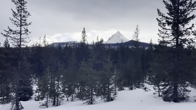
THE INCREDIBLE MOUNT WASHINGTON!!!!!!!!!!!!!!!!!! – Ray Benson Sno-Park – Central Oregon – 4K
My goal of these wilderness trail videos is to 1) show reverence for the beauty of the land, and 2) give YOU actionable trail information that can assist you in planning your own hike here.
This was a day-hike in Central Oregon, Willamette National Forest, Ray Benson Sno Park, hiking South Loop by Hayrick Butte and Claypool Butte to Brandeberg Butte and Brandenberg Rustic Log Cabin Shelter, approximately 5.8 miles and 350 FT Elevation Gain. With some other Ray Benson Sno-Park Exploration and hiking Claypool Butte I do more like 7 miles and 500 FT Elevation Gain. ***A WORD OF CAUTION - I WOULD NOT RECOMMEND TAKING THE ALLTRAILS ROUTE OF A LOLLIPOP - once you get to Brandenberg Shelter, I would recommend turning around and backtracking making it an Out and Back. That may seem counterintuitive since you are immediately going back uphill, however that is still less exertion than the next two miles on the Lollipop Loop to connect back to the Stick so to speak since it is not a well defined grooved or packed down trail! That two miles was the hardest of the whole hike, had to break trail and use GPS to track the way through the forest since the path wasn't at all evident. There also aren't really any good views in that section, mostly just meadows and thick forest, so I would highly recommend skipping that and going back up Brandenberg Butte so you get the Mountain Views again and stay on a more trackable path.*** Snowshoes in my humble opinion are a must, I would not attempt this is Yaktrax because several sections are just too thick of snow to not be postholing for miles. This was the warmest day in a long time, low of 31 around Sunrise when I got there with a high of 43, however it did likely sprinkle for hours combined with the winds made this a particularly wet and cold hike given the weather profile going in. This was hiked on 1/13/2023, yes Friday the 13th!, and there were of NO Mosquitoes. As far as road conditions, it's highway and well paved roads until the turnoff for Ray Benson Sno-Park, the last couple tenths although on a well defined road were actually pretty slippery and icy, and the giant parking lot was also a sheet of ice. In my opinion, the road DOES NOT require 4-Wheel Drive, however do watch for road conditions, particularly snow/ice depending on the time of year and drive VERY CAUTIOUSLY.
-
 6:48
6:48
HikingViking
1 month ago(4K UHD) HIKING HIGHLIGHTS - Winter Sunrise Arriving @ North Shore Fishing Pier @ Haystack Reservoir
60 -
 LIVE
LIVE
Welcome to the Rebellion Podcast
11 hours agoOh Obama - WTTR Podcast Live 7/21
144 watching -
 LIVE
LIVE
The Bubba Army
2 days agoShannon Sharpe Settles Rape Lawsuit - Bubba the Love Sponge® Show | 7/21/25
3,686 watching -
 16:07
16:07
Clownfish TV
3 hours agoAstronomer CEO 'Resigns' After Coldplay Kiss Cam Becomes a Meme!
1.89K9 -
 32:32
32:32
Ohio State Football and Recruiting at Buckeye Huddle
14 hours agoOhio State Football: The 10 Best Players of the Ryan Day Era
3.23K -
 15:45
15:45
Professor Gerdes Explains 🇺🇦
1 day agoThe Two-Front War Nobody's Ready For - NATO Commander Breaks It Down
1.43K1 -
 LIVE
LIVE
BEK TV
1 hour agoTrent Loos in the Morning 7/21/2025
147 watching -
 39:31
39:31
Athlete & Artist Show
17 hours ago $1.55 earnedBaby Boychuk Is BORN, Playing With Nick Tarnasky In The WHL
15K4 -
 16:20
16:20
World2Briggs
1 day ago $2.18 earnedTop 10 Affordable Mountain Towns in the U.S.
14.9K3 -
 15:16
15:16
Fit'n Fire
22 hours ago $2.03 earnedThe Beretta 92X Performance
14K7