

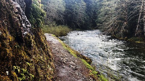
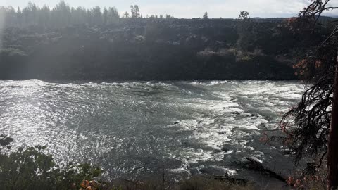
ROARIN' & RIVETING RIVER & REMARKABLE RAINFOREST! | SALMON RIVER | MOUNT HOOD | OREGON | 4K
This was a day-hike in the Salmon Huckleberry Wilderness of the Mount Hood Area, starting at West Salmon River Trailhead and hiking above and beside the National Wild & Scenic River of Salmon River hiking through a very rocky Old Growth Rainforest. The trail goes on for dozens of miles and is a backpacking route, however if you want to just do a Day-Hike, I would suggest one of three options - the "Short Route" (about 7.6 miles), the "Medium Route" to Goat Creek Camp (a little over 9 miles) or the "Long Route" to the Trail Junction of Kinzel Lake, Devil's Tooth, and Devil's Peak (about 11.2 miles), each as a good potential turnaround spot for your Out and Back River Day-Hike. The elevation starts around 1600 FT and goes to around 2600 FT, and with the natural machinations of the Old Growth Rainforest Trail you gain about 1200 feet in elevation which I would consider "Moderate". This trail is accessible as early as February in some years, often in the March/April/May Spring range, of course, based on the annual snow levels. The sky was overcast with a high of 50 and low of 34, I arrived a little after sunrise. This was hiked on 5/11/2022 and there were of course NO Mosquitoes. As far as road conditions, it's highway to the turn off for Salmon River which is a paved road with a few bumps along the way until the parking lot gravel area, so it was a very easy and safe driving route. In my opinion, the road most definitely DOES NOT require 4-Wheel Drive, however do watch for road conditions, particularly snow/ice depending on the time of year.
62
views
4
comments
EXPLORING THE EPIC Salmon River & Rainforest Wilderness Shoreline in Mount Hood Area of Oregon 4K!
This was a day-hike in the Salmon Huckleberry Wilderness of the Mount Hood Area, starting at West Salmon River Trailhead and hiking above and beside the National Wild & Scenic River of Salmon River hiking through a very rocky Old Growth Rainforest. The trail goes on for dozens of miles and is a backpacking route, however if you want to just do a Day-Hike, I would suggest one of three options - the "Short Route" (about 7.6 miles), the "Medium Route" to Goat Creek Camp (a little over 9 miles) or the "Long Route" to the Trail Junction of Kinzel Lake, Devil's Tooth, and Devil's Peak (about 11.2 miles), each as a good potential turnaround spot for your Out and Back River Day-Hike. The elevation starts around 1600 FT and goes to around 2600 FT, and with the natural machinations of the Old Growth Rainforest Trail you gain about 1200 feet in elevation which I would consider "Moderate". This trail is accessible as early as February in some years, often in the March/April/May Spring range, of course, based on the annual snow levels. The sky was overcast with a high of 50 and low of 34, I arrived a little after sunrise. This was hiked on 5/11/2022 and there were of course NO Mosquitoes. As far as road conditions, it's highway to the turn off for Salmon River which is a paved road with a few bumps along the way until the parking lot gravel area, so it was a very easy and safe driving route. In my opinion, the road most definitely DOES NOT require 4-Wheel Drive, however do watch for road conditions, particularly snow/ice depending on the time of year.
91
views
7
comments
12 MINUTES OF SOOTHING SILENCE! | National Wild & Scenic Deschutes River | Central Oregon | 4K
A silent collection of sections of National Wild & Scenic Deschutes River in Central Oregon in 4K!
155
views
5
comments
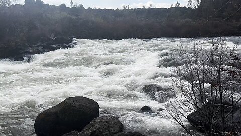
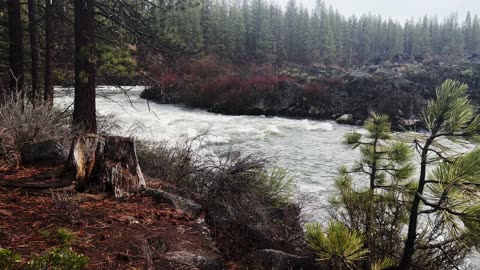
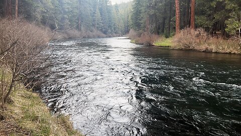
EXPLORING THE EPIC Volcanic Lava River WONDERLAND of Deschutes River in Central Oregon 4K!
This was a day-hike in Central Oregon, Deschutes National Forest, starting at Meadow Day Use Area Trailhead and hiking to Lava Island, Big Eddy, Aspen, and then Dillon Falls along the Shoreline of Deschutes River as an Out and Back hiking approximately 8 miles with only a couple hundred feet elevation gain. I call this the "Northern Half" of Upper Deschutes River Hiking (the "Southern Half" starts at Sun Lava Path Trailhead and goes to Benham Falls and then also Dillon Falls, also approximately 8 miles). The temperature was in the 30's when I started and it rained heavily intermittently with occasional sunbreaks and a rainbow. This was hiked on 5/6/2022 and there were of course NO Mosquitoes. As far as road conditions, it's highway and then a relatively well maintained road to the parking lot. In my opinion, the road most definitely DOES NOT require 4-Wheel Drive, however do watch for road conditions, particularly snow/ice depending on the time of year.
92
views
10
comments

Hiking & Exploring a Volcanic Lava Rock River Forest PARADISE in Central Oregon 4K!
This was a day-hike in Central Oregon, Deschutes National Forest, starting at Meadow Day Use Area Trailhead and hiking to Lava Island, Big Eddy, Aspen, and then Dillon Falls along the Shoreline of Deschutes River as an Out and Back hiking approximately 8 miles with only a couple hundred feet elevation gain. I call this the "Northern Half" of Upper Deschutes River Hiking (the "Southern Half" starts at Sun Lava Path Trailhead and goes to Benham Falls and then also Dillon Falls, also approximately 8 miles). The temperature was in the 30's when I started and it rained heavily intermittently with occasional sunbreaks and a rainbow. This was hiked on 5/6/2022 and there were of course NO Mosquitoes. As far as road conditions, it's highway and then a relatively well maintained road to the parking lot. In my opinion, the road most definitely DOES NOT require 4-Wheel Drive, however do watch for road conditions, particularly snow/ice depending on the time of year.
37
views

Volcanic Lava Rock River Forest MAJESTIC BEAUTY in Central Oregon 4K!
This was a day-hike in Central Oregon, Deschutes National Forest, starting at Meadow Day Use Area Trailhead and hiking to Lava Island, Big Eddy, Aspen, and then Dillon Falls along the Shoreline of Deschutes River as an Out and Back hiking approximately 8 miles with only a couple hundred feet elevation gain. I call this the "Northern Half" of Upper Deschutes River Hiking (the "Southern Half" starts at Sun Lava Path Trailhead and goes to Benham Falls and then also Dillon Falls, also approximately 8 miles). The temperature was in the 30's when I started and it rained heavily intermittently with occasional sunbreaks and a rainbow. This was hiked on 5/6/2022 and there were of course NO Mosquitoes. As far as road conditions, it's highway and then a relatively well maintained road to the parking lot. In my opinion, the road most definitely DOES NOT require 4-Wheel Drive, however do watch for road conditions, particularly snow/ice depending on the time of year.
27
views
EXPLORING THE EPIC Deschutes River Down To Shoreline & INCREDIBLE CLOUD FORMATION 4K!
This was a day-hike in Central Oregon, Deschutes National Forest, starting at Meadow Day Use Area Trailhead and hiking to Lava Island, Big Eddy, Aspen, and then Dillon Falls along the Shoreline of Deschutes River as an Out and Back hiking approximately 8 miles with only a couple hundred feet elevation gain. I call this the "Northern Half" of Upper Deschutes River Hiking (the "Southern Half" starts at Sun Lava Path Trailhead and goes to Benham Falls and then also Dillon Falls, also approximately 8 miles). The temperature was in the 30's when I started and it rained heavily intermittently with occasional sunbreaks and a rainbow. This was hiked on 5/6/2022 and there were of course NO Mosquitoes. As far as road conditions, it's highway and then a relatively well maintained road to the parking lot. In my opinion, the road most definitely DOES NOT require 4-Wheel Drive, however do watch for road conditions, particularly snow/ice depending on the time of year.
38
views
2
comments

Vibrant Wildlife Hiking in Rain & RUSTIC Edifice Lookout Above Deschutes River Central Oregon 4K!
This was a day-hike in Central Oregon, Deschutes National Forest, starting at Meadow Day Use Area Trailhead and hiking to Lava Island, Big Eddy, Aspen, and then Dillon Falls along the Shoreline of Deschutes River as an Out and Back hiking approximately 8 miles with only a couple hundred feet elevation gain. I call this the "Northern Half" of Upper Deschutes River Hiking (the "Southern Half" starts at Sun Lava Path Trailhead and goes to Benham Falls and then also Dillon Falls, also approximately 8 miles). The temperature was in the 30's when I started and it rained heavily intermittently with occasional sunbreaks and a rainbow. This was hiked on 5/6/2022 and there were of course NO Mosquitoes. As far as road conditions, it's highway and then a relatively well maintained road to the parking lot. In my opinion, the road most definitely DOES NOT require 4-Wheel Drive, however do watch for road conditions, particularly snow/ice depending on the time of year.
45
views
2
comments
GORGEOUS & MAGICAL Hiking Overlooking EPIC Deschutes River in Central Oregon 4K!
This was a day-hike in Central Oregon, Deschutes National Forest, starting at Meadow Day Use Area Trailhead and hiking to Lava Island, Big Eddy, Aspen, and then Dillon Falls along the Shoreline of Deschutes River as an Out and Back hiking approximately 8 miles with only a couple hundred feet elevation gain. I call this the "Northern Half" of Upper Deschutes River Hiking (the "Southern Half" starts at Sun Lava Path Trailhead and goes to Benham Falls and then also Dillon Falls, also approximately 8 miles). The temperature was in the 30's when I started and it rained heavily intermittently with occasional sunbreaks and a rainbow. This was hiked on 5/6/2022 and there were of course NO Mosquitoes. As far as road conditions, it's highway and then a relatively well maintained road to the parking lot. In my opinion, the road most definitely DOES NOT require 4-Wheel Drive, however do watch for road conditions, particularly snow/ice depending on the time of year.
46
views
2
comments
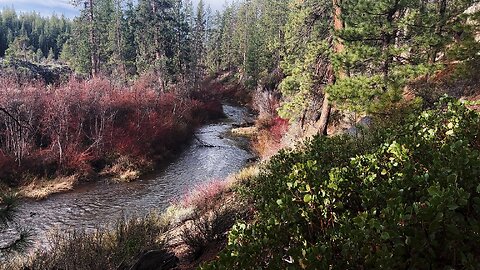
EXPLORING THE EPIC Metolius River Forested Shoreline in Central Oregon 4K!
This was a day-hike in Central Oregon, Deschutes National Forest, Metolius River National Recreation Area, starting at Lower Bridge Campground Parking at Lower Bridge and first exploring the East side of Metolius River to Pioneer Ford Campground for the first little part of the hike as a small segment Out and Back. The bulk of the hike was after crossing the bridge to the trailhead for West Metolius River Trail to Candle Creek Campground (WITH CAMPSITE REVIEW VIDEOS - BEST SITES - #6, #5, #4 in that order) as a 3.2 miles Out and Back with miles of epic shoreline hiking and a minor amount of elevation gain making it mostly a flat hike. The elevation starts around 2800 FT and stays in a range of up to 3000 FT, at such low elevation it allows this hike to be done in the end of Winter (late Feb and forward) as far as snow melt and road access. The sky was overcast and it sprinkled a little bit. This was hiked on 4/28/2022, and there were of course NO Mosquitoes. As far as road conditions, it's highway to the turn off for the Camp Sherman area which is a well paved road until the parking lot, so it was a very easy and safe driving route. In my opinion, the road most definitely DOES NOT require 4-Wheel Drive, however do watch for road conditions, particularly snow/ice depending on the time of year.
79
views
Crossing RUSTIC Log Bridge & JADE Colored Metolius River in Central Oregon 4K!
This was a day-hike in Central Oregon, Deschutes National Forest, Metolius River National Recreation Area, starting at Lower Bridge Campground Parking at Lower Bridge and first exploring the East side of Metolius River to Pioneer Ford Campground for the first little part of the hike as a small segment Out and Back. The bulk of the hike was after crossing the bridge to the trailhead for West Metolius River Trail to Candle Creek Campground (WITH CAMPSITE REVIEW VIDEOS - BEST SITES - #6, #5, #4 in that order) as a 3.2 miles Out and Back with miles of epic shoreline hiking and a minor amount of elevation gain making it mostly a flat hike. The elevation starts around 2800 FT and stays in a range of up to 3000 FT, at such low elevation it allows this hike to be done in the end of Winter (late Feb and forward) as far as snow melt and road access. The sky was overcast and it sprinkled a little bit. This was hiked on 4/28/2022, and there were of course NO Mosquitoes. As far as road conditions, it's highway to the turn off for the Camp Sherman area which is a well paved road until the parking lot, so it was a very easy and safe driving route. In my opinion, the road most definitely DOES NOT require 4-Wheel Drive, however do watch for road conditions, particularly snow/ice depending on the time of year.
44
views
2
comments
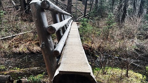
FINAL REVIEW OF CANDLE CREEK CAMPGROUND @ METOLIUS RIVER IN CENTRAL OREGON!
BEST SITES - #6, #5, #4, in that order. Those are the three what I would personally consider *PREMIUM* campsites @ Candle Creek Campground on Metolius River!
This was a day-hike in Central Oregon, Deschutes National Forest, Metolius River National Recreation Area, starting at Lower Bridge Campground Parking at Lower Bridge and first exploring the East side of Metolius River to Pioneer Ford Campground for the first little part of the hike as a small segment Out and Back. The bulk of the hike was after crossing the bridge to the trailhead for West Metolius River Trail to Candle Creek Campground (WITH CAMPSITE REVIEW VIDEOS - BEST SITES - #6, #5, #4 in that order) as a 3.2 miles Out and Back with miles of epic shoreline hiking and a minor amount of elevation gain making it mostly a flat hike. The elevation starts around 2800 FT and stays in a range of up to 3000 FT, at such low elevation it allows this hike to be done in the end of Winter (late Feb and forward) as far as snow melt and road access. The sky was overcast and it sprinkled a little bit. This was hiked on 4/28/2022, and there were of course NO Mosquitoes. As far as road conditions, it's highway to the turn off for the Camp Sherman area which is a well paved road until the parking lot, so it was a very easy and safe driving route. In my opinion, the road most definitely DOES NOT require 4-Wheel Drive, however do watch for road conditions, particularly snow/ice depending on the time of year.
292
views
4
comments

4K HIGHLIGHTS of EPIC Steelhead Falls Wilderness Area & Deschutes River in AUTUMN FALL COLORS 4K!
This was a day-hike in Central Oregon, Steelhead Falls Wilderness Study Area, starting at Steelhead Falls Trailhead and hiking a truly epic 2 Mile Out and Back, approximately 226 FT Elevation Gain (mostly on the way back up), descending into the incredible Deschutes River Desert Canyon Basin culminating in the spectacular Steelhead Falls! This was hiked on 11/2/2021 with AUTUMN FALL COLORS in full bloom! If you just want to go to the Steelhead Falls Lookout Zone and back it is only half of that distance, 1 Mile Roundtrip. If you go past that you get to a more rugged section of trail and take that all the way to the end of the Desert Basin Canyon. Weather was a low of 40, high of 56, overcast cloudy day and mildly windy. Trail was completely clear of snow, and there were NO Mosquitoes! On Alltrails, this hike is called "Steelhead Falls". As far as road conditions, it's highway and paved side streets until the last few tenths of a mile or so which is gravel, you want to take this part slowly and cautiously but it's fairly easy, in my opinion, the road most definitely DOES NOT require 4-Wheel Drive. As far as permits, the Steelhead Falls Trailhead DOES NOT require a Recreation.gov permit.
326
views
2
comments
THE INCREDIBLE MOUNT WASHINGTON!!!!!!!!!!!!!!!!!! – Ray Benson Sno-Park – Central Oregon – 4K
My goal of these wilderness trail videos is to 1) show reverence for the beauty of the land, and 2) give YOU actionable trail information that can assist you in planning your own hike here.
This was a day-hike in Central Oregon, Willamette National Forest, Ray Benson Sno Park, hiking South Loop by Hayrick Butte and Claypool Butte to Brandeberg Butte and Brandenberg Rustic Log Cabin Shelter, approximately 5.8 miles and 350 FT Elevation Gain. With some other Ray Benson Sno-Park Exploration and hiking Claypool Butte I do more like 7 miles and 500 FT Elevation Gain. ***A WORD OF CAUTION - I WOULD NOT RECOMMEND TAKING THE ALLTRAILS ROUTE OF A LOLLIPOP - once you get to Brandenberg Shelter, I would recommend turning around and backtracking making it an Out and Back. That may seem counterintuitive since you are immediately going back uphill, however that is still less exertion than the next two miles on the Lollipop Loop to connect back to the Stick so to speak since it is not a well defined grooved or packed down trail! That two miles was the hardest of the whole hike, had to break trail and use GPS to track the way through the forest since the path wasn't at all evident. There also aren't really any good views in that section, mostly just meadows and thick forest, so I would highly recommend skipping that and going back up Brandenberg Butte so you get the Mountain Views again and stay on a more trackable path.*** Snowshoes in my humble opinion are a must, I would not attempt this is Yaktrax because several sections are just too thick of snow to not be postholing for miles. This was the warmest day in a long time, low of 31 around Sunrise when I got there with a high of 43, however it did likely sprinkle for hours combined with the winds made this a particularly wet and cold hike given the weather profile going in. This was hiked on 1/13/2023, yes Friday the 13th!, and there were of NO Mosquitoes. As far as road conditions, it's highway and well paved roads until the turnoff for Ray Benson Sno-Park, the last couple tenths although on a well defined road were actually pretty slippery and icy, and the giant parking lot was also a sheet of ice. In my opinion, the road DOES NOT require 4-Wheel Drive, however do watch for road conditions, particularly snow/ice depending on the time of year and drive VERY CAUTIOUSLY.
162
views
9
comments
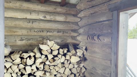
STOP DOING GRAFFITI ON RUSTIC LOG CABIN SHELTERS! – Ray Benson Sno-Park – Central Oregon – 4K
My goal of these wilderness trail videos is to 1) show reverence for the beauty of the land, and 2) give YOU actionable trail information that can assist you in planning your own hike here.
This was a day-hike in Central Oregon, Willamette National Forest, Ray Benson Sno Park, hiking South Loop by Hayrick Butte and Claypool Butte to Brandeberg Butte and Brandenberg Rustic Log Cabin Shelter, approximately 5.8 miles and 350 FT Elevation Gain. With some other Ray Benson Sno-Park Exploration and hiking Claypool Butte I do more like 7 miles and 500 FT Elevation Gain. ***A WORD OF CAUTION - I WOULD NOT RECOMMEND TAKING THE ALLTRAILS ROUTE OF A LOLLIPOP - once you get to Brandenberg Shelter, I would recommend turning around and backtracking making it an Out and Back. That may seem counterintuitive since you are immediately going back uphill, however that is still less exertion than the next two miles on the Lollipop Loop to connect back to the Stick so to speak since it is not a well defined grooved or packed down trail! That two miles was the hardest of the whole hike, had to break trail and use GPS to track the way through the forest since the path wasn't at all evident. There also aren't really any good views in that section, mostly just meadows and thick forest, so I would highly recommend skipping that and going back up Brandenberg Butte so you get the Mountain Views again and stay on a more trackable path.*** Snowshoes in my humble opinion are a must, I would not attempt this is Yaktrax because several sections are just too thick of snow to not be postholing for miles. This was the warmest day in a long time, low of 31 around Sunrise when I got there with a high of 43, however it did likely sprinkle for hours combined with the winds made this a particularly wet and cold hike given the weather profile going in. This was hiked on 1/13/2023, yes Friday the 13th!, and there were of NO Mosquitoes. As far as road conditions, it's highway and well paved roads until the turnoff for Ray Benson Sno-Park, the last couple tenths although on a well defined road were actually pretty slippery and icy, and the giant parking lot was also a sheet of ice. In my opinion, the road DOES NOT require 4-Wheel Drive, however do watch for road conditions, particularly snow/ice depending on the time of year and drive VERY CAUTIOUSLY.
158
views
5
comments
Descending STEEP Butte & Arriving at Brandenberg Shelter! – Ray Benson Sno-Park – Central Oregon – 4K
My goal of these wilderness trail videos is to 1) show reverence for the beauty of the land, and 2) give YOU actionable trail information that can assist you in planning your own hike here.
This was a day-hike in Central Oregon, Willamette National Forest, Ray Benson Sno Park, hiking South Loop by Hayrick Butte and Claypool Butte to Brandeberg Butte and Brandenberg Rustic Log Cabin Shelter, approximately 5.8 miles and 350 FT Elevation Gain. With some other Ray Benson Sno-Park Exploration and hiking Claypool Butte I do more like 7 miles and 500 FT Elevation Gain. ***A WORD OF CAUTION - I WOULD NOT RECOMMEND TAKING THE ALLTRAILS ROUTE OF A LOLLIPOP - once you get to Brandenberg Shelter, I would recommend turning around and backtracking making it an Out and Back. That may seem counterintuitive since you are immediately going back uphill, however that is still less exertion than the next two miles on the Lollipop Loop to connect back to the Stick so to speak since it is not a well defined grooved or packed down trail! That two miles was the hardest of the whole hike, had to break trail and use GPS to track the way through the forest since the path wasn't at all evident. There also aren't really any good views in that section, mostly just meadows and thick forest, so I would highly recommend skipping that and going back up Brandenberg Butte so you get the Mountain Views again and stay on a more trackable path.*** Snowshoes in my humble opinion are a must, I would not attempt this is Yaktrax because several sections are just too thick of snow to not be postholing for miles. This was the warmest day in a long time, low of 31 around Sunrise when I got there with a high of 43, however it did likely sprinkle for hours combined with the winds made this a particularly wet and cold hike given the weather profile going in. This was hiked on 1/13/2023, yes Friday the 13th!, and there were of NO Mosquitoes. As far as road conditions, it's highway and well paved roads until the turnoff for Ray Benson Sno-Park, the last couple tenths although on a well defined road were actually pretty slippery and icy, and the giant parking lot was also a sheet of ice. In my opinion, the road DOES NOT require 4-Wheel Drive, however do watch for road conditions, particularly snow/ice depending on the time of year and drive VERY CAUTIOUSLY.
61
views
2
comments

EXPLORING THE INCREDIBLE ALPINE WONDERLAND VIA SNOWSHOE! – Ray Benson Sno-Park – Central Oregon – 4K
My goal of these wilderness trail videos is to 1) show reverence for the beauty of the land, and 2) give YOU actionable trail information that can assist you in planning your own hike here.
This was a day-hike in Central Oregon, Willamette National Forest, Ray Benson Sno Park, hiking South Loop by Hayrick Butte and Claypool Butte to Brandeberg Butte and Brandenberg Rustic Log Cabin Shelter, approximately 5.8 miles and 350 FT Elevation Gain. With some other Ray Benson Sno-Park Exploration and hiking Claypool Butte I do more like 7 miles and 500 FT Elevation Gain. ***A WORD OF CAUTION - I WOULD NOT RECOMMEND TAKING THE ALLTRAILS ROUTE OF A LOLLIPOP - once you get to Brandenberg Shelter, I would recommend turning around and backtracking making it an Out and Back. That may seem counterintuitive since you are immediately going back uphill, however that is still less exertion than the next two miles on the Lollipop Loop to connect back to the Stick so to speak since it is not a well defined grooved or packed down trail! That two miles was the hardest of the whole hike, had to break trail and use GPS to track the way through the forest since the path wasn't at all evident. There also aren't really any good views in that section, mostly just meadows and thick forest, so I would highly recommend skipping that and going back up Brandenberg Butte so you get the Mountain Views again and stay on a more trackable path.*** Snowshoes in my humble opinion are a must, I would not attempt this is Yaktrax because several sections are just too thick of snow to not be postholing for miles. This was the warmest day in a long time, low of 31 around Sunrise when I got there with a high of 43, however it did likely sprinkle for hours combined with the winds made this a particularly wet and cold hike given the weather profile going in. This was hiked on 1/13/2023, yes Friday the 13th!, and there were of NO Mosquitoes. As far as road conditions, it's highway and well paved roads until the turnoff for Ray Benson Sno-Park, the last couple tenths although on a well defined road were actually pretty slippery and icy, and the giant parking lot was also a sheet of ice. In my opinion, the road DOES NOT require 4-Wheel Drive, however do watch for road conditions, particularly snow/ice depending on the time of year and drive VERY CAUTIOUSLY.
51
views
1
comment
EPIC Views of MOUNT WASHINGTON from Brandenberg Butte! – Ray Benson Sno-Park – Central Oregon – 4K
My goal of these wilderness trail videos is to 1) show reverence for the beauty of the land, and 2) give YOU actionable trail information that can assist you in planning your own hike here.
This was a day-hike in Central Oregon, Willamette National Forest, Ray Benson Sno Park, hiking South Loop by Hayrick Butte and Claypool Butte to Brandeberg Butte and Brandenberg Rustic Log Cabin Shelter, approximately 5.8 miles and 350 FT Elevation Gain. With some other Ray Benson Sno-Park Exploration and hiking Claypool Butte I do more like 7 miles and 500 FT Elevation Gain. ***A WORD OF CAUTION - I WOULD NOT RECOMMEND TAKING THE ALLTRAILS ROUTE OF A LOLLIPOP - once you get to Brandenberg Shelter, I would recommend turning around and backtracking making it an Out and Back. That may seem counterintuitive since you are immediately going back uphill, however that is still less exertion than the next two miles on the Lollipop Loop to connect back to the Stick so to speak since it is not a well defined grooved or packed down trail! That two miles was the hardest of the whole hike, had to break trail and use GPS to track the way through the forest since the path wasn't at all evident. There also aren't really any good views in that section, mostly just meadows and thick forest, so I would highly recommend skipping that and going back up Brandenberg Butte so you get the Mountain Views again and stay on a more trackable path.*** Snowshoes in my humble opinion are a must, I would not attempt this is Yaktrax because several sections are just too thick of snow to not be postholing for miles. This was the warmest day in a long time, low of 31 around Sunrise when I got there with a high of 43, however it did likely sprinkle for hours combined with the winds made this a particularly wet and cold hike given the weather profile going in. This was hiked on 1/13/2023, yes Friday the 13th!, and there were of NO Mosquitoes. As far as road conditions, it's highway and well paved roads until the turnoff for Ray Benson Sno-Park, the last couple tenths although on a well defined road were actually pretty slippery and icy, and the giant parking lot was also a sheet of ice. In my opinion, the road DOES NOT require 4-Wheel Drive, however do watch for road conditions, particularly snow/ice depending on the time of year and drive VERY CAUTIOUSLY.
72
views
2
comments
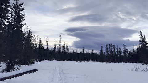
INCREDIBLE Cloud Formation in an Alpine Wonderland! – Ray Benson Sno-Park – Central Oregon – 4K
My goal of these wilderness trail videos is to 1) show reverence for the beauty of the land, and 2) give YOU actionable trail information that can assist you in planning your own hike here.
This was a day-hike in Central Oregon, Willamette National Forest, Ray Benson Sno Park, hiking South Loop by Hayrick Butte and Claypool Butte to Brandeberg Butte and Brandenberg Rustic Log Cabin Shelter, approximately 5.8 miles and 350 FT Elevation Gain. With some other Ray Benson Sno-Park Exploration and hiking Claypool Butte I do more like 7 miles and 500 FT Elevation Gain. ***A WORD OF CAUTION - I WOULD NOT RECOMMEND TAKING THE ALLTRAILS ROUTE OF A LOLLIPOP - once you get to Brandenberg Shelter, I would recommend turning around and backtracking making it an Out and Back. That may seem counterintuitive since you are immediately going back uphill, however that is still less exertion than the next two miles on the Lollipop Loop to connect back to the Stick so to speak since it is not a well defined grooved or packed down trail! That two miles was the hardest of the whole hike, had to break trail and use GPS to track the way through the forest since the path wasn't at all evident. There also aren't really any good views in that section, mostly just meadows and thick forest, so I would highly recommend skipping that and going back up Brandenberg Butte so you get the Mountain Views again and stay on a more trackable path.*** Snowshoes in my humble opinion are a must, I would not attempt this is Yaktrax because several sections are just too thick of snow to not be postholing for miles. This was the warmest day in a long time, low of 31 around Sunrise when I got there with a high of 43, however it did likely sprinkle for hours combined with the winds made this a particularly wet and cold hike given the weather profile going in. This was hiked on 1/13/2023, yes Friday the 13th!, and there were of NO Mosquitoes. As far as road conditions, it's highway and well paved roads until the turnoff for Ray Benson Sno-Park, the last couple tenths although on a well defined road were actually pretty slippery and icy, and the giant parking lot was also a sheet of ice. In my opinion, the road DOES NOT require 4-Wheel Drive, however do watch for road conditions, particularly snow/ice depending on the time of year and drive VERY CAUTIOUSLY.
44
views
2
comments
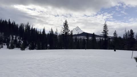
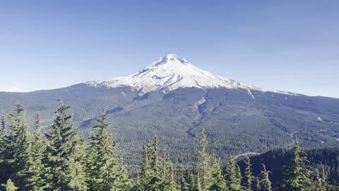
Ascending EXPOSED BOULDER SECTION of SUMMIT TRAIL! – Mount Hood – Oregon – 4K
My goal of these wilderness trail videos is to 1) show reverence for the beauty of the land, and 2) give YOU actionable trail information that can assist you in planning your own hike here.
This was a day-hike in Oregon, Mount Hood National Forest, Mirror Lake Trailhead, hiking up to Mirror Lake, circumnavigating the lake, and continuing on to the Summit of Tom Dick & Harry Mountain, approximately 9.2 miles and 1700 FT Elevation Gain. The Summit is 4997 FT, pretty low for wilderness standards, so this entire hike is in the subalpine zone, short of the 5000 FT Alpine Zone by 3 FT! It was a sheet of ice on much of the trail, so Yaktrax or Microspikes required as far as I'm concerned, and the sky was mostly blue and clear. This was hiked on 11/24/2022 (Thanksgiving!) and there were of NO Mosquitoes. As far as road conditions, it's highway and well paved roads until the parking lot, so it was a very easy and safe driving route. In my opinion, the road most definitely DOES NOT require 4-Wheel Drive, however do watch for road conditions, particularly snow/ice depending on the time of year.
39
views
4
comments
Mount Hood Summit in WINDY Peace & Serenity! – Mount Hood – Oregon – 4K
My goal of these wilderness trail videos is to 1) show reverence for the beauty of the land, and 2) give YOU actionable trail information that can assist you in planning your own hike here.
This was a day-hike in Oregon, Mount Hood National Forest, Mirror Lake Trailhead, hiking up to Mirror Lake, circumnavigating the lake, and continuing on to the Summit of Tom Dick & Harry Mountain, approximately 9.2 miles and 1700 FT Elevation Gain. The Summit is 4997 FT, pretty low for wilderness standards, so this entire hike is in the subalpine zone, short of the 5000 FT Alpine Zone by 3 FT! It was a sheet of ice on much of the trail, so Yaktrax or Microspikes required as far as I'm concerned, and the sky was mostly blue and clear. This was hiked on 11/24/2022 (Thanksgiving!) and there were of NO Mosquitoes. As far as road conditions, it's highway and well paved roads until the parking lot, so it was a very easy and safe driving route. In my opinion, the road most definitely DOES NOT require 4-Wheel Drive, however do watch for road conditions, particularly snow/ice depending on the time of year.
21
views
SHADOW and LIGHT on BEAUTIFUL FROZEN Mirror Lake! – Mount Hood – Oregon – 4K
My goal of these wilderness trail videos is to 1) show reverence for the beauty of the land, and 2) give YOU actionable trail information that can assist you in planning your own hike here.
This was a day-hike in Oregon, Mount Hood National Forest, Mirror Lake Trailhead, hiking up to Mirror Lake, circumnavigating the lake, and continuing on to the Summit of Tom Dick & Harry Mountain, approximately 9.2 miles and 1700 FT Elevation Gain. The Summit is 4997 FT, pretty low for wilderness standards, so this entire hike is in the subalpine zone, short of the 5000 FT Alpine Zone by 3 FT! It was a sheet of ice on much of the trail, so Yaktrax or Microspikes required as far as I'm concerned, and the sky was mostly blue and clear. This was hiked on 11/24/2022 (Thanksgiving!) and there were of NO Mosquitoes. As far as road conditions, it's highway and well paved roads until the parking lot, so it was a very easy and safe driving route. In my opinion, the road most definitely DOES NOT require 4-Wheel Drive, however do watch for road conditions, particularly snow/ice depending on the time of year.
13
views

Ascending the Snowy Summit Trail of Tom, Dick & Harry Mountain – Oregon – 4K
My goal of these wilderness trail videos is to 1) show reverence for the beauty of the land, and 2) give YOU actionable trail information that can assist you in planning your own hike here.
This was a day-hike in Oregon, Mount Hood National Forest, Mirror Lake Trailhead, hiking up to Mirror Lake, circumnavigating the lake, and continuing on to the Summit of Tom Dick & Harry Mountain, approximately 9.2 miles and 1700 FT Elevation Gain. The Summit is 4997 FT, pretty low for wilderness standards, so this entire hike is in the subalpine zone, short of the 5000 FT Alpine Zone by 3 FT! It was a sheet of ice on much of the trail, so Yaktrax or Microspikes required as far as I'm concerned, and the sky was mostly blue and clear. This was hiked on 11/24/2022 (Thanksgiving!) and there were of NO Mosquitoes. As far as road conditions, it's highway and well paved roads until the parking lot, so it was a very easy and safe driving route. In my opinion, the road most definitely DOES NOT require 4-Wheel Drive, however do watch for road conditions, particularly snow/ice depending on the time of year.
19
views

EPIC APPROACH to the INCREDIBLE MONEYSHOT of FROZEN Mirror Lake! – Mount Hood – Oregon – 4K
My goal of these wilderness trail videos is to 1) show reverence for the beauty of the land, and 2) give YOU actionable trail information that can assist you in planning your own hike here.
This was a day-hike in Oregon, Mount Hood National Forest, Mirror Lake Trailhead, hiking up to Mirror Lake, circumnavigating the lake, and continuing on to the Summit of Tom Dick & Harry Mountain, approximately 9.2 miles and 1700 FT Elevation Gain. The Summit is 4997 FT, pretty low for wilderness standards, so this entire hike is in the subalpine zone, short of the 5000 FT Alpine Zone by 3 FT! It was a sheet of ice on much of the trail, so Yaktrax or Microspikes required as far as I'm concerned, and the sky was mostly blue and clear. This was hiked on 11/24/2022 (Thanksgiving!) and there were of NO Mosquitoes. As far as road conditions, it's highway and well paved roads until the parking lot, so it was a very easy and safe driving route. In my opinion, the road most definitely DOES NOT require 4-Wheel Drive, however do watch for road conditions, particularly snow/ice depending on the time of year.
31
views
2
comments

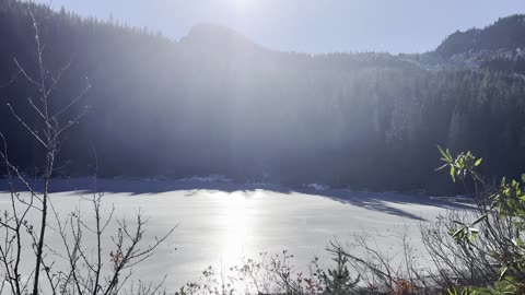
Arriving at the SHORELINE of FROZEN Mirror Lake! – Mount Hood – Oregon – 4K
My goal of these wilderness trail videos is to 1) show reverence for the beauty of the land, and 2) give YOU actionable trail information that can assist you in planning your own hike here.
This was a day-hike in Oregon, Mount Hood National Forest, Mirror Lake Trailhead, hiking up to Mirror Lake, circumnavigating the lake, and continuing on to the Summit of Tom Dick & Harry Mountain, approximately 9.2 miles and 1700 FT Elevation Gain. The Summit is 4997 FT, pretty low for wilderness standards, so this entire hike is in the subalpine zone, short of the 5000 FT Alpine Zone by 3 FT! It was a sheet of ice on much of the trail, so Yaktrax or Microspikes required as far as I'm concerned, and the sky was mostly blue and clear. This was hiked on 11/24/2022 (Thanksgiving!) and there were of NO Mosquitoes. As far as road conditions, it's highway and well paved roads until the parking lot, so it was a very easy and safe driving route. In my opinion, the road most definitely DOES NOT require 4-Wheel Drive, however do watch for road conditions, particularly snow/ice depending on the time of year.
18
views
2
comments