
BITE-SIZED WILDS | Alpine Autumn Awesomeness @ Mount Hood! | Timberline Loop | Oregon | 4K
This was a 13.7 mile, 2900 FT Elevation Gain Day-Hike in Oregon, Mount Hood Wilderness, focusing on the SW Quadrant of the approximately 40-mile EPIC Timberline Loop that goes around Mount Hood (one of the two best alpine backpacking hikes in Oregon along with Broken Top Loop), starting at Timberline Lodge Pacific Crest Trailhead, and hiking West towards Little Zig Zag Canyon, Zig Zag Canyon, crossing Zig Zag River and ultimately to Paradise Park and Paradise Branch Falls Lookout as our turnaround point as an out and back Day-Hike. Weather was a low of 34, high of 59, blue sky day and mildly to moderately windy. This was hiked on 10/3/2021 with fall colors in transition or full bloom, trail was completely clear of snow, and there were NO Mosquitoes! On Alltrails, this hike is called "Timberline Trail Around Mount Hood", with a focus on the SW Quadrant. As far as road conditions, it's highway until the turnoff for Timberline Lodge, and a well paved road all the way up the 6 miles to the parking lot. This is as easy and convenient of a trailhead parking as you will ever find. In my opinion, the road most definitely DOES NOT require 4-Wheel Drive. As far as permits, the Timberline Lodge Pacific Crest Trailhead DOES NOT require a Recreation.gov permit.
29
views
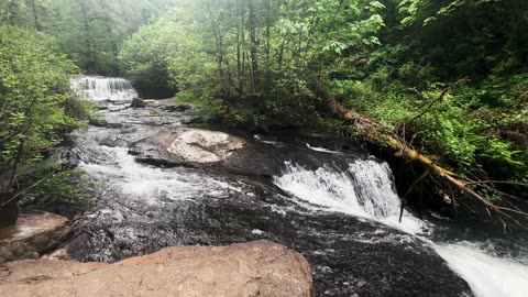
Hiking VIBRANT GREEN Soda Springs Trail to South Santiam River! | Cascadia County Park | Oregon | 4K
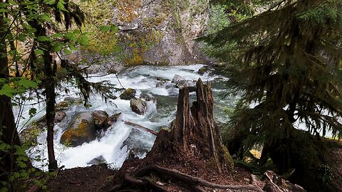
Hiking Exploring the luscious vibrant green Soda Springs Trail down to South Santiam River Shoreline in Cascadia County Park (formerly State), Central Oregon in 4K! This video was made on 5/20/23. Mosquitoes were non-existent.
41
views

GORGEOUS, TRANQUIL & SERENE Shoreline Perspective of South Santiam River! | Central Oregon | 4K
The perspective from the wild shoreline along South Santiam River, Central Oregon, in 4K! This video was made on 5/21/23. Mosquitoes were non-existent.
27
views

The BEAUTIFUL PEACEFUL South Santiam River Shoreline @ Trout Creek Campground! | Central Oregon | 4K
Exploring the Shoreline of South Santiam River @ Trout Creek Campground (bookable at Recreation.gov), Willamette National Forest, Central Oregon in 4K! This video was made on 5/21/23. Mosquitoes were non-existent.
40
views
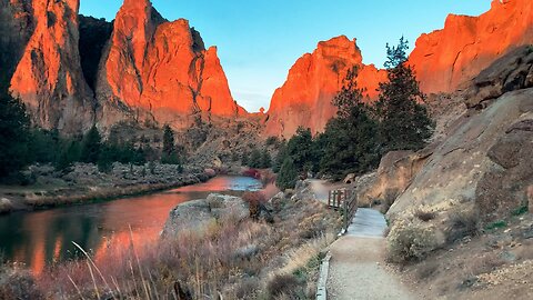
Exploring the "Dihedrals" Climbers Zone @ Sunrise! | Smith Rock State Park | Central Oregon | 4K
This was an EPIC day-hike in Central Oregon at Sunrise exploring the INCREDIBLE “River Trail” at Smith Rock State Park, easily a TOP 3 State Park in the entire State of Oregon in my humble opinion! This hike was timed for the epic sunrise glow on the GORGEOUS canyon faces, starting at River Trail Trailhead before sunrise and hiking parallel to Crooked River ultimately to Monkey Face and a bit beyond as my turnaround point. I explored several of the primary “side trails” aka “climbers trails” of River Trail – Morning Glory Wall, Dihedrals, Asterisk Pass, and a few others with beautiful panoramic expansive viewpoints. Weather was below freezing chilly and quite windy with a low of 29, high of 54, with beautiful classic blue clear sky. This was hiked on 11/8/2021 with fall colors in transition or full bloom, the trail was completely clear of snow, and there were NO Mosquitoes! As far as road conditions, it could not be more easy, paved roads all the way to the parking lot. In my opinion, the road most definitely DOES NOT require 4-Wheel Drive. As far as permits, the River Trail Trailhead DOES NOT require a Recreation.gov permit but IS a State Park.
77
views

Exploring the "Morning Glory Wall" Zone @ Sunrise! | Smith Rock State Park | Central Oregon | 4K
This was an EPIC day-hike in Central Oregon at Sunrise exploring the INCREDIBLE “River Trail” at Smith Rock State Park, easily a TOP 3 State Park in the entire State of Oregon in my humble opinion! This hike was timed for the epic sunrise glow on the GORGEOUS canyon faces, starting at River Trail Trailhead before sunrise and hiking parallel to Crooked River ultimately to Monkey Face and a bit beyond as my turnaround point. I explored several of the primary “side trails” aka “climbers trails” of River Trail – Morning Glory Wall, Dihedrals, Asterisk Pass, and a few others with beautiful panoramic expansive viewpoints. Weather was below freezing chilly and quite windy with a low of 29, high of 54, with beautiful classic blue clear sky. This was hiked on 11/8/2021 with fall colors in transition or full bloom, the trail was completely clear of snow, and there were NO Mosquitoes! As far as road conditions, it could not be more easy, paved roads all the way to the parking lot. In my opinion, the road most definitely DOES NOT require 4-Wheel Drive. As far as permits, the River Trail Trailhead DOES NOT require a Recreation.gov permit but IS a State Park.
129
views
2
comments
EXPLORING THE EPIC PARADISE "River Trail" @ Sunrise! | Smith Rock State Park | Central Oregon | 4K
This was an EPIC day-hike in Central Oregon at Sunrise exploring the INCREDIBLE “River Trail” at Smith Rock State Park, easily a TOP 3 State Park in the entire State of Oregon in my humble opinion! This hike was timed for the epic sunrise glow on the GORGEOUS canyon faces, starting at River Trail Trailhead before sunrise and hiking parallel to Crooked River ultimately to Monkey Face and a bit beyond as my turnaround point. I explored several of the primary “side trails” aka “climbers trails” of River Trail – Morning Glory Wall, Dihedrals, Asterisk Pass, and a few others with beautiful panoramic expansive viewpoints. Weather was below freezing chilly and quite windy with a low of 29, high of 54, with beautiful classic blue clear sky. This was hiked on 11/8/2021 with fall colors in transition or full bloom, the trail was completely clear of snow, and there were NO Mosquitoes! As far as road conditions, it could not be more easy, paved roads all the way to the parking lot. In my opinion, the road most definitely DOES NOT require 4-Wheel Drive. As far as permits, the River Trail Trailhead DOES NOT require a Recreation.gov permit but IS a State Park.
138
views
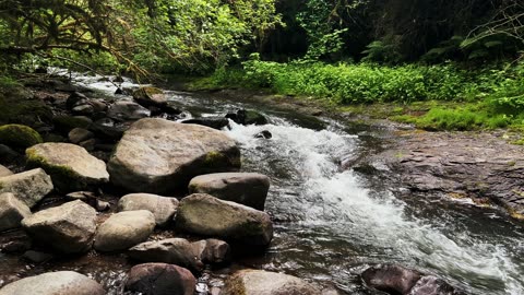
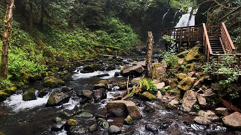
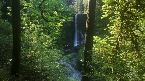
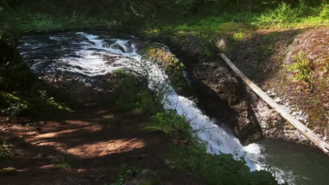
Hiking the STEEP Stairs Up Above Royal Terrace Falls! | McDowell Creek County Park | Oregon | 4K
McDowell Creek County Park is managed by Linn County in Oregon. The area can be best captured by a very comfortable 1.7 mile, approximately 300 FT Elevation Gain Loop that parallels both Falls Creek and McDowell Creek and hikes by Royal Terrace Falls (119 FT, Tiered Waterfall) and Majestic Falls (39 FT, Curtain Waterfall). Lower McDowell Falls is near the lower parking lot and not part of the classic Loop Trail. To access it, go to the right of the Trailhead Signage Map through a series of individual day use picnic sites and you will fine a narrow trail that leads down to Creekside with two different vantage points of Lower McDowell Falls (Tiered Waterfall). In my humble opinion, this is a world class Waterfall hike with three GORGEOUS Waterfalls, a bit of an undiscovered gem and most definitely worth hiking and exploring!
94
views
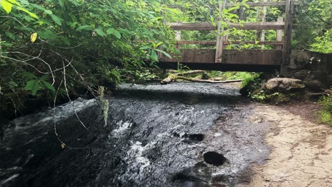
TRANQUIL & SERENE Falls Creek & Crossing First Bridge! | McDowell Creek County Park | Oregon | 4K
McDowell Creek County Park is managed by Linn County in Oregon. The area can be best captured by a very comfortable 1.7 mile, approximately 300 FT Elevation Gain Loop that parallels both Falls Creek and McDowell Creek and hikes by Royal Terrace Falls (119 FT, Tiered Waterfall) and Majestic Falls (39 FT, Curtain Waterfall). Lower McDowell Falls is near the lower parking lot and not part of the classic Loop Trail. To access it, go to the right of the Trailhead Signage Map through a series of individual day use picnic sites and you will fine a narrow trail that leads down to Creekside with two different vantage points of Lower McDowell Falls (Tiered Waterfall). In my humble opinion, this is a world class Waterfall hike with three GORGEOUS Waterfalls, a bit of an undiscovered gem and most definitely worth hiking and exploring!
79
views
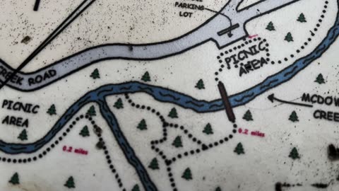
Detailed Trailhead Informational Sign & Hiking Map @ McDowell Creek County Park | Oregon | 4K
McDowell Creek County Park is managed by Linn County in Oregon. The area can be best captured by a very comfortable 1.7 mile, approximately 300 FT Elevation Gain Loop that parallels both Falls Creek and McDowell Creek and hikes by Royal Terrace Falls (119 FT, Tiered Waterfall) and Majestic Falls (39 FT, Curtain Waterfall). Lower McDowell Falls is near the lower parking lot and not part of the classic Loop Trail. To access it, go to the right of the Trailhead Signage Map through a series of individual day use picnic sites and you will fine a narrow trail that leads down to Creekside with two different vantage points of Lower McDowell Falls (Tiered Waterfall). In my humble opinion, this is a world class Waterfall hike with three GORGEOUS Waterfalls, a bit of an undiscovered gem and most definitely worth hiking and exploring!
79
views
13 MINUTES OF SOOTHING SILENCE! | Waterfalls & Creeks | McDowell Creek County Park | Oregon | 4K
McDowell Creek County Park is managed by Linn County in Oregon. The area can be best captured by a very comfortable 1.7 mile, approximately 300 FT Elevation Gain Loop that parallels both Falls Creek and McDowell Creek and hikes by Royal Terrace Falls (119 FT, Tiered Waterfall) and Majestic Falls (39 FT, Curtain Waterfall). Lower McDowell Falls is near the lower parking lot and not part of the classic Loop Trail. To access it, go to the right of the Trailhead Signage Map through a series of individual day use picnic sites and you will fine a narrow trail that leads down to Creekside with two different vantage points of Lower McDowell Falls (Tiered Waterfall). In my humble opinion, this is a world class Waterfall hike with three GORGEOUS Waterfalls, a bit of an undiscovered gem and most definitely worth hiking and exploring!
101
views
EXPLORING THE WILD & RUSTIC Royal Terrace Falls Area! | McDowell Creek County Park | Oregon | 4K
McDowell Creek County Park is managed by Linn County in Oregon. The area can be best captured by a very comfortable 1.7 mile, approximately 300 FT Elevation Gain Loop that parallels both Falls Creek and McDowell Creek and hikes by Royal Terrace Falls (119 FT, Tiered Waterfall) and Majestic Falls (39 FT, Curtain Waterfall). Lower McDowell Falls is near the lower parking lot and not part of the classic Loop Trail. To access it, go to the right of the Trailhead Signage Map through a series of individual day use picnic sites and you will fine a narrow trail that leads down to Creekside with two different vantage points of Lower McDowell Falls (Tiered Waterfall). In my humble opinion, this is a world class Waterfall hike with three GORGEOUS Waterfalls, a bit of an undiscovered gem and most definitely worth hiking and exploring!
47
views
EXPLORING THE EPIC & GORGEOUS Majestic Falls Zone! | McDowell Creek County Park | Oregon | 4K
McDowell Creek County Park is managed by Linn County in Oregon. The area can be best captured by a very comfortable 1.7 mile, approximately 300 FT Elevation Gain Loop that parallels both Falls Creek and McDowell Creek and hikes by Royal Terrace Falls (119 FT, Tiered Waterfall) and Majestic Falls (39 FT, Curtain Waterfall). Lower McDowell Falls is near the lower parking lot and not part of the classic Loop Trail. To access it, go to the right of the Trailhead Signage Map through a series of individual day use picnic sites and you will fine a narrow trail that leads down to Creekside with two different vantage points of Lower McDowell Falls (Tiered Waterfall). In my humble opinion, this is a world class Waterfall hike with three GORGEOUS Waterfalls, a bit of an undiscovered gem and most definitely worth hiking and exploring!
39
views
SHORELINE PERSPECTIVE of Tiered Lower McDowell Falls! | McDowell Creek County Park | Oregon | 4K
McDowell Creek County Park is managed by Linn County in Oregon. The area can be best captured by a very comfortable 1.7 mile, approximately 300 FT Elevation Gain Loop that parallels both Falls Creek and McDowell Creek and hikes by Royal Terrace Falls (119 FT, Tiered Waterfall) and Majestic Falls (39 FT, Curtain Waterfall). Lower McDowell Falls is near the lower parking lot and not part of the classic Loop Trail. To access it, go to the right of the Trailhead Signage Map through a series of individual day use picnic sites and you will fine a narrow trail that leads down to Creekside with two different vantage points of Lower McDowell Falls (Tiered Waterfall). In my humble opinion, this is a world class Waterfall hike with three GORGEOUS Waterfalls, a bit of an undiscovered gem and most definitely worth hiking and exploring!
38
views
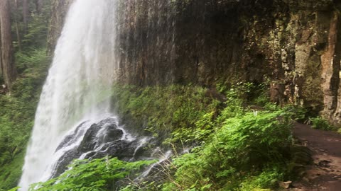
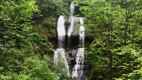
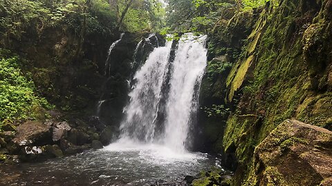
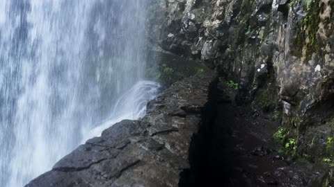
HIKING UNDER Middle North Waterfall! | Trail of Ten Falls | Silver Falls State Park | Oregon | 4K
This was a 7.4 mile, 1200 FT Elevation Gain Loop Hike of the ABSOLUTELY INCREDIBLE Trail of Ten Falls, Silver Falls State Park, Oregon, in 4K! This is unquestionably the BEST WATERFALL HIKE IN OREGON, and a TOP 5 WATERFALL HIKE IN THE ENTIRE USA, so it is truly EPIC and absolutely worth putting on your bucket list to experience. They almost designated this a National Park many years ago (I'm glad they didn't for logistical reasons), it is truly a natural beauty wonderland to behold. This was hiked on 5/20/23, the weather was classic Spring in Oregon with some sunshine and overcast, and there were no mosquitoes.
I hiked the Loop Clockwise and would recommend the same route. The Ten Waterfalls in order hiking Clockwise are:
1) South Falls - 177 FT (can walk behind!) (hiking beside South Fork Silver Creek)
2) Lower South Falls - 93 FT (can walk behind!) (hiking beside South Fork Silver Creek)
3) Lower North Falls - 30 FT (hiking beside North Fork Silver Creek)
4) Double Falls - 178 FT (hiking beside North Fork Silver Creek)
5) Drake Falls - 27 FT (hiking beside North Fork Silver Creek)
6) Middle North Falls - 106 FT (can walk behind!) (hiking beside North Fork Silver Creek)
7) Twin Falls - 31 FT (hiking beside North Fork Silver Creek)
8) North Falls - 136 FT (can walk behind!) (hiking beside North Fork Silver Creek)
9) Upper North Falls - 65 FT
10) Winter Falls - 134 FT
My favorites were the four you could walk behind, not just for that reason but they were also the most beautiful Waterfall Basins and most awe-inspiring overall. All Ten Waterfalls are very high quality and each one could be a destination hike on its own, so for them to be put together all in one EPIC Sensory Overload Waterfall Loop Hike is truly spectacular!
104
views
7
comments
Hiking BEHIND Lower South Waterfall! | Trail of Ten Falls | Silver Falls State Park | Oregon | 4K
This was a 7.4 mile, 1200 FT Elevation Gain Loop Hike of the ABSOLUTELY INCREDIBLE Trail of Ten Falls, Silver Falls State Park, Oregon, in 4K! This is unquestionably the BEST WATERFALL HIKE IN OREGON, and a TOP 5 WATERFALL HIKE IN THE ENTIRE USA, so it is truly EPIC and absolutely worth putting on your bucket list to experience. They almost designated this a National Park many years ago (I'm glad they didn't for logistical reasons), it is truly a natural beauty wonderland to behold. This was hiked on 5/20/23, the weather was classic Spring in Oregon with some sunshine and overcast, and there were no mosquitoes.
I hiked the Loop Clockwise and would recommend the same route. The Ten Waterfalls in order hiking Clockwise are:
1) South Falls - 177 FT (can walk behind!) (hiking beside South Fork Silver Creek)
2) Lower South Falls - 93 FT (can walk behind!) (hiking beside South Fork Silver Creek)
3) Lower North Falls - 30 FT (hiking beside North Fork Silver Creek)
4) Double Falls - 178 FT (hiking beside North Fork Silver Creek)
5) Drake Falls - 27 FT (hiking beside North Fork Silver Creek)
6) Middle North Falls - 106 FT (can walk behind!) (hiking beside North Fork Silver Creek)
7) Twin Falls - 31 FT (hiking beside North Fork Silver Creek)
8) North Falls - 136 FT (can walk behind!) (hiking beside North Fork Silver Creek)
9) Upper North Falls - 65 FT
10) Winter Falls - 134 FT
My favorites were the four you could walk behind, not just for that reason but they were also the most beautiful Waterfall Basins and most awe-inspiring overall. All Ten Waterfalls are very high quality and each one could be a destination hike on its own, so for them to be put together all in one EPIC Sensory Overload Waterfall Loop Hike is truly spectacular!
88
views
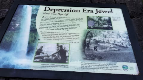
Informational Signs @ Silver Falls State Park (Pause to Read) | Trail of Ten Falls | Oregon | 4K
This was a 7.4 mile, 1200 FT Elevation Gain Loop Hike of the ABSOLUTELY INCREDIBLE Trail of Ten Falls, Silver Falls State Park, Oregon, in 4K! This is unquestionably the BEST WATERFALL HIKE IN OREGON, and a TOP 5 WATERFALL HIKE IN THE ENTIRE USA, so it is truly EPIC and absolutely worth putting on your bucket list to experience. They almost designated this a National Park many years ago (I'm glad they didn't for logistical reasons), it is truly a natural beauty wonderland to behold. This was hiked on 5/20/23, the weather was classic Spring in Oregon with some sunshine and overcast, and there were no mosquitoes.
I hiked the Loop Clockwise and would recommend the same route. The Ten Waterfalls in order hiking Clockwise are:
1) South Falls - 177 FT (can walk behind!) (hiking beside South Fork Silver Creek)
2) Lower South Falls - 93 FT (can walk behind!) (hiking beside South Fork Silver Creek)
3) Lower North Falls - 30 FT (hiking beside North Fork Silver Creek)
4) Double Falls - 178 FT (hiking beside North Fork Silver Creek)
5) Drake Falls - 27 FT (hiking beside North Fork Silver Creek)
6) Middle North Falls - 106 FT (can walk behind!) (hiking beside North Fork Silver Creek)
7) Twin Falls - 31 FT (hiking beside North Fork Silver Creek)
8) North Falls - 136 FT (can walk behind!) (hiking beside North Fork Silver Creek)
9) Upper North Falls - 65 FT
10) Winter Falls - 134 FT
My favorites were the four you could walk behind, not just for that reason but they were also the most beautiful Waterfall Basins and most awe-inspiring overall. All Ten Waterfalls are very high quality and each one could be a destination hike on its own, so for them to be put together all in one EPIC Sensory Overload Waterfall Loop Hike is truly spectacular!
39
views
STANDING UNDERNEATH North Waterfall! | Trail of Ten Falls | Silver Falls State Park | Oregon | 4K
This was a 7.4 mile, 1200 FT Elevation Gain Loop Hike of the ABSOLUTELY INCREDIBLE Trail of Ten Falls, Silver Falls State Park, Oregon, in 4K! This is unquestionably the BEST WATERFALL HIKE IN OREGON, and a TOP 5 WATERFALL HIKE IN THE ENTIRE USA, so it is truly EPIC and absolutely worth putting on your bucket list to experience. They almost designated this a National Park many years ago (I'm glad they didn't for logistical reasons), it is truly a natural beauty wonderland to behold. This was hiked on 5/20/23, the weather was classic Spring in Oregon with some sunshine and overcast, and there were no mosquitoes.
I hiked the Loop Clockwise and would recommend the same route. The Ten Waterfalls in order hiking Clockwise are:
1) South Falls - 177 FT (can walk behind!) (hiking beside South Fork Silver Creek)
2) Lower South Falls - 93 FT (can walk behind!) (hiking beside South Fork Silver Creek)
3) Lower North Falls - 30 FT (hiking beside North Fork Silver Creek)
4) Double Falls - 178 FT (hiking beside North Fork Silver Creek)
5) Drake Falls - 27 FT (hiking beside North Fork Silver Creek)
6) Middle North Falls - 106 FT (can walk behind!) (hiking beside North Fork Silver Creek)
7) Twin Falls - 31 FT (hiking beside North Fork Silver Creek)
8) North Falls - 136 FT (can walk behind!) (hiking beside North Fork Silver Creek)
9) Upper North Falls - 65 FT
10) Winter Falls - 134 FT
My favorites were the four you could walk behind, not just for that reason but they were also the most beautiful Waterfall Basins and most awe-inspiring overall. All Ten Waterfalls are very high quality and each one could be a destination hike on its own, so for them to be put together all in one EPIC Sensory Overload Waterfall Loop Hike is truly spectacular!
34
views
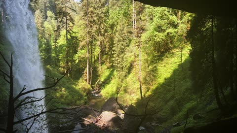
Middle North Waterfall View from afar! | Trail of Ten Falls | Silver Falls State Park | Oregon | 4K
This was a 7.4 mile, 1200 FT Elevation Gain Loop Hike of the ABSOLUTELY INCREDIBLE Trail of Ten Falls, Silver Falls State Park, Oregon, in 4K! This is unquestionably the BEST WATERFALL HIKE IN OREGON, and a TOP 5 WATERFALL HIKE IN THE ENTIRE USA, so it is truly EPIC and absolutely worth putting on your bucket list to experience. They almost designated this a National Park many years ago (I'm glad they didn't for logistical reasons), it is truly a natural beauty wonderland to behold. This was hiked on 5/20/23, the weather was classic Spring in Oregon with some sunshine and overcast, and there were no mosquitoes.
I hiked the Loop Clockwise and would recommend the same route. The Ten Waterfalls in order hiking Clockwise are:
1) South Falls - 177 FT (can walk behind!) (hiking beside South Fork Silver Creek)
2) Lower South Falls - 93 FT (can walk behind!) (hiking beside South Fork Silver Creek)
3) Lower North Falls - 30 FT (hiking beside North Fork Silver Creek)
4) Double Falls - 178 FT (hiking beside North Fork Silver Creek)
5) Drake Falls - 27 FT (hiking beside North Fork Silver Creek)
6) Middle North Falls - 106 FT (can walk behind!) (hiking beside North Fork Silver Creek)
7) Twin Falls - 31 FT (hiking beside North Fork Silver Creek)
8) North Falls - 136 FT (can walk behind!) (hiking beside North Fork Silver Creek)
9) Upper North Falls - 65 FT
10) Winter Falls - 134 FT
My favorites were the four you could walk behind, not just for that reason but they were also the most beautiful Waterfall Basins and most awe-inspiring overall. All Ten Waterfalls are very high quality and each one could be a destination hike on its own, so for them to be put together all in one EPIC Sensory Overload Waterfall Loop Hike is truly spectacular!
36
views
Overlooking BEAUTIFUL Twin Waterfall! | Trail of Ten Falls | Silver Falls State Park | Oregon | 4K
This was a 7.4 mile, 1200 FT Elevation Gain Loop Hike of the ABSOLUTELY INCREDIBLE Trail of Ten Falls, Silver Falls State Park, Oregon, in 4K! This is unquestionably the BEST WATERFALL HIKE IN OREGON, and a TOP 5 WATERFALL HIKE IN THE ENTIRE USA, so it is truly EPIC and absolutely worth putting on your bucket list to experience. They almost designated this a National Park many years ago (I'm glad they didn't for logistical reasons), it is truly a natural beauty wonderland to behold. This was hiked on 5/20/23, the weather was classic Spring in Oregon with some sunshine and overcast, and there were no mosquitoes.
I hiked the Loop Clockwise and would recommend the same route. The Ten Waterfalls in order hiking Clockwise are:
1) South Falls - 177 FT (can walk behind!) (hiking beside South Fork Silver Creek)
2) Lower South Falls - 93 FT (can walk behind!) (hiking beside South Fork Silver Creek)
3) Lower North Falls - 30 FT (hiking beside North Fork Silver Creek)
4) Double Falls - 178 FT (hiking beside North Fork Silver Creek)
5) Drake Falls - 27 FT (hiking beside North Fork Silver Creek)
6) Middle North Falls - 106 FT (can walk behind!) (hiking beside North Fork Silver Creek)
7) Twin Falls - 31 FT (hiking beside North Fork Silver Creek)
8) North Falls - 136 FT (can walk behind!) (hiking beside North Fork Silver Creek)
9) Upper North Falls - 65 FT
10) Winter Falls - 134 FT
My favorites were the four you could walk behind, not just for that reason but they were also the most beautiful Waterfall Basins and most awe-inspiring overall. All Ten Waterfalls are very high quality and each one could be a destination hike on its own, so for them to be put together all in one EPIC Sensory Overload Waterfall Loop Hike is truly spectacular!
32
views
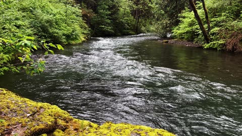
SOOTHING PEACEFUL SILENCE | Shoreline Perspective of South Santiam River! | Central Oregon | 4K
The perspective from the wild shoreline along South Santiam River, Central Oregon, in 4K! This video was made on 5/21/23. Mosquitoes were non-existent.
104
views
3
comments

Bridge Perspectives Overlooking MIGHTY & BEAUTIFUL South Santiam River! | Central Oregon | 4K
The perspective from various bridge vantage points along South Santiam River, Central Oregon, in 4K! This video was made on 5/21/23. Mosquitoes were non-existent.
70
views
2
comments

SOOTHING SILENCE & TRANQUILITY | South Santiam River @ Trout Creek Campground! | Central Oregon | 4K
A silent collection of sections of South Santiam River @ Trout Creek Campground (bookable at Recreation.gov), Willamette National Forest, Central Oregon in 4K! This video was made on 5/21/23. Mosquitoes were non-existent.
50
views
5
comments
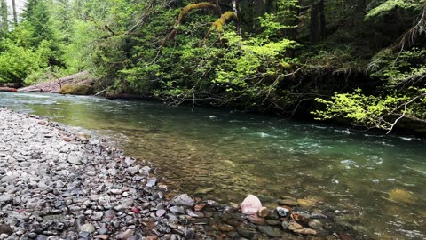
2+ MINUTES OF SOOTHING SILENCE! | House Rock Campground @ South Santiam River! | Central Oregon | 4K
A silent collection of sections of South Santiam River at House Rock Campground, Willamette National Forest, Central Oregon in 4K! This video was made on 5/21/23. Mosquitoes were non-existent.
*Please note - there is a separate silent collection of sections of House Rock Falls video as well.
28
views
SOOTHING SILENCE & TRANQUILITY | GORGEOUS House Rock Falls! | South Santiam River | Oregon | 4K
A silent video of sections of INCREDIBLE House Rock Falls, flowing into South Santiam River, near House Rock Campground, Willamette National Forest, Central Oregon, in 4K! This video was made on 5/21/23. Mosquitoes were non-existent.
*Please note - there is a separate silent video of sections of House Rock Campground and a full hiking video of Santiam Wagon Trail exploring House Rock.
29
views