Gino Recchia NBC26 Weather Forecast
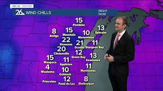
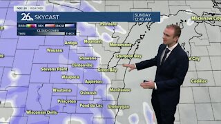
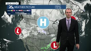
It will be a nice day out with mostly sunny skies today and light winds out of the northwest around 5 to 10 mph. With calming winds and clear skies tonight, temperatures will fall into the single digits and lower teens. High pressure sticks around for our Wednesday, that means more sunshine and highs in the lower to mid 30s once again. The clouds thicken as we head into Wednesday night, temperatures fall into the mid 20s. Snow is looking likely Thursday as an area of low pressure moves in. How much snow remains the question but it is looking like at least a couple of inches, some data is suggesting around a half foot. In either case, we will be adding to our snow pack all across Northeast Wisconsin. This will be a wet and heavy snow with temperature close to 32, so take your time when shoveling. Some snowfall may linger for the first half of our Friday as a reinforcing shot of cold air moves in behind this storm. Highs will be near 20 on Friday. It only gets colder from here. We will continue to see temperatures drop heading into the weekend with highs in the single digits to near zero and lows below zero. This will be the coldest air of the winter so far.
-
 1:57
1:57
WGBA
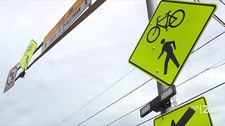
7 months agoHow the City of Green Bay is hoping a $1.6M investment will make the community safer for pedestrians
921 -
 3:31
3:31
WGBA
3 years agoGino Recchia NBC26 Weather Forecast
6 -
 0:02
0:02
WGBA
3 years agoGino Recchia NBC26 Weather Forecast
171 -
 3:59
3:59
WGBA
3 years agoGino Recchia NBC26 Weather Forecast
24 -
 3:24
3:24
WGBA
3 years agoGino Recchia NBC26 Weather Forecast
18 -
 3:11
3:11
WGBA
3 years agoGino Recchia NBC26 Weather Forecast
17 -
 3:15
3:15
WGBA
3 years agoGino Recchia NBC26 Weather Forecast
13 -
 3:19
3:19
WGBA
3 years agoGino Recchia NBC26 Weather Forecast
7 -
 3:29
3:29
WGBA
3 years agoGino Recchia NBC26 Weather Forecast
24 -
 3:22
3:22
WGBA
3 years agoGino Recchia NBC26 Weather Forecast
11