Gino Recchia NBC26 Weather Forecast
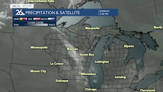
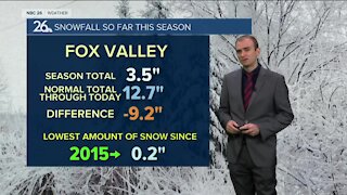
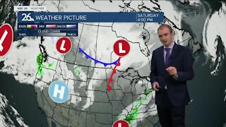
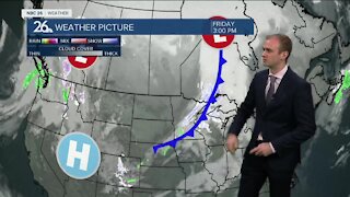
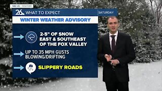
We are tracking a clipper system coming in from Canada tonight into Monday morning. Most areas look to pick up a dusting to an inch of snow. There will likely be some higher totals with 1-2 inches in the Northwoods. With afternoon highs getting into the mid 30s, snow will transition to a wintry mix or light rain. Expect a good amount of the snow to melt off during the daytime hours. Tuesday will have mostly cloudy skies with highs in the mid 30s. Another chance of snow or wintry mix will move in on Wednesday. This would be the last chance of seeing some accumulation before Christmas. The chance of having a White Christmas will hang in the balance of how this storm tracks and whether we see temperatures rise into the upper 30s and low 40s with any remaining snow melting, or the storm tracking further south and our area seeing colder temperatures with some accumulations. Regardless of the storm, Christmas Eve and Christmas day will have the some of the coldest high temperatures this winter season so far. The cold spell will be short lived as highs are expected to get into the lower 30s by the end of next weekend.
-
 1:45
1:45
WGBA
8 months agoStudents excited to start at "huge and beautiful" Vel Phillips Middle School
56 -
 3:25
3:25
WGBA
3 years agoGino Recchia NBC26 Weather Forecast
7 -
 3:21
3:21
WGBA
3 years agoGino Recchia NBC26 Weather Forecast
4 -
 3:09
3:09
WGBA
3 years agoGino Recchia NBC26 Weather Forecast
6 -
 3:23
3:23
WGBA
3 years agoGino Recchia NBC26 Weather Forecast
3 -
 3:12
3:12
WGBA
3 years agoGino Recchia NBC26 Weather Forecast
2 -
 3:16
3:16
WGBA
3 years agoGino Recchia NBC26 Weather Forecast
3 -
 3:31
3:31
WGBA
3 years agoGino Recchia NBC26 Weather Forecast
6 -
 3:20
3:20
WGBA
3 years agoGino Recchia NBC26 Weather Forecast
4 -
 4:06
4:06
WGBA
3 years agoGino Recchia NBC26 Weather Forecast
6