
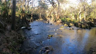
Solo Backpacking Trip at Devils Den State Park along the Butterfield Trail
The Butterfield Hiking Trail is a 14.7 mile loop that takes you through the Ozark National Forest and the Ozark Mountains. Over the 14.7 miles the trail takes you over creeks, through historical rock quarries, caves and crevices, over bluffs, and breath taking overlooks. The highest point of the trail is an elevation of 1772 feet. There are a number of established campsites along the trail. You can turn this trail into a 2 or 3 day hike/ backpacking depending on your skill level. The most popular camp ground is about 9 miles in and is call Junction Camp. This is where Lee Creek and Black Berry Creek meet up. There is plenty of fresh water sources along the trail. There is even a few water falls if you find your self lucky enough to be there after a good rain. The trail can be hiked/ backpacked clockwise or counter clock wise. I choose to hike/ backpack this trail clockwise. You will need to stop at the Parks Visitor Center to obtain a permit. Due to the recent resections you will need to were a mask and there are not to be more then 2 people in the office at one time. It took me over an hour to get my permit. There is a simple questionnaire that you need to fill out and once that is done the Office will issue you a free permit. The Park Office will give you a map the is worthless and would better be used as a fire starter then a map. I used the All Trails app for this full hike/ backpacking. There is cell service on all of the high points that you can update the app if you are using the free version. I will have a link below for All Trails. The Trail is very will marked with blue blazers and mile markers (which do not match the map) and the trail is well traveled.
https://www.alltrails.com/trail/us/arkansas/butterfield-hiking-trail
https://www.arkansasstateparks.com/trails/butterfield-hiking-trail
-
 5:38
5:38
Ozark Adventures and Reviews
4 years agoSimple Spicy Shrimp and Rice Dish. Cajun Cooking and Recipes Made Easy. 30 Minute Meal Idea
781 -
 6:38
6:38
Ozark Adventures and Reviews
4 years ago $0.01 earnedBackpacking Pigeon Roost Trail in Hobbs State Park. Camping there for a Solo Overnighter
58 -
 17:41
17:41
Todd and Sheila's Outdoor Adventures
4 years ago $0.03 earnedRapids Trail Hike at Hillsborough River State Park
822 -
 5:16
5:16
sam477
4 years agoSouth Mountain Trail Fun - Pawtuckaway State Park, New Hamphsire
78 -
 4:06
4:06
charlievw
4 years ago $0.01 earnedKickapoo State park 2020 Trout fishing trip!
184 -
 1:53
1:53
harv41
4 years agoBackpacking trip
331 -
 1:21
1:21
Saffire77
4 years agoOn the Dinosaur Trail. Makoshika State Park, Montana
43 -
 1:02
1:02
Drockton5
4 years agoSalt fork state park
1041 -
 27:35
27:35
EvanOneill
4 years ago $0.01 earned100 Mile Overnight Bike Ride | New River Trail State Park
170 -
 0:52
0:52
Kayak Adventures
4 years agoAiken State Park
60