
NBC26 Storm Shield weather forecast
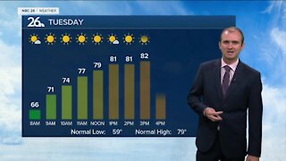
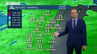
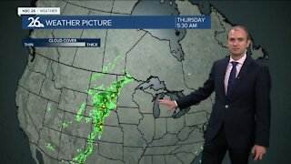
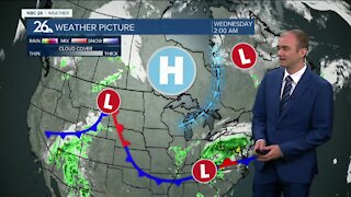
Thanks to high pressure the wind will be dying down tonight with clear skies. Temps will drop into the single digits & low-teens. Tuesday should be a pretty nice day with plenty of sun and highs in the low/mid 40s. The wind won't be that bad either. We have a relatively slow-moving low pressure on the way that will affect us starting Tuesday night. Slowly rain will start to develop as the night goes on. This could be a little freezing rain in spots as well, but the temperatures will actually be rising above freezing as the night progresses. This low pressure will slowly be tracking through, but time we will be in the warm sector of the storm. Temperatures will rise into the mid/upper-40s on Wednesday and 50s to around on Thursday, though it may be cooler by Lake Michigan! Both days will come with rainfall. We cool off Friday with highs in the mid-30s to upper-30s with a risk of a few flurries or some light rain or snow showers as this system moves away. If we manage to hit the 50 degree mark, it will be the warmest day since November 23rd, over 100 days ago.
-
 3:36
3:36
WGBA
1 year agoWill it be necessary to have both the AC & the heat on during the same day??
2991 -
 3:24
3:24
WGBA
3 years agoGino Recchia NBC26 Weather Forecast
2 -
 3:32
3:32
WGBA
3 years agoGino Recchia NBC26 Weather Forecast
6 -
 3:54
3:54
WGBA
3 years agoGino Recchia NBC26 Weather Forecast
2 -
 2:46
2:46
WGBA
3 years agoGino Recchia NBC26 Weather Forecast
2 -
 2:54
2:54
WGBA
3 years agoGino Recchia NBC26 Weather Forecast
3 -
 2:41
2:41
WGBA
3 years agoGino Recchia NBC26 Weather Forecast
2 -
 3:11
3:11
WGBA
3 years agoGino Recchia NBC26 Weather Forecast
2 -
 3:14
3:14
WGBA
3 years agoGino Recchia NBC26 Weather Forecast
9 -
 2:52
2:52
WGBA
3 years agoGino Recchia NBC26 Weather Forecast
5