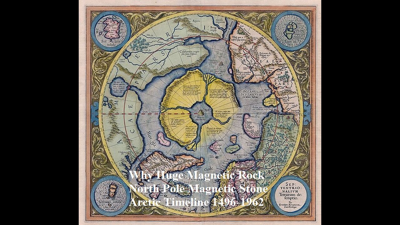
Why Huge Magnetic Rock North Pole Magnetic Stone An Arctic Timeline 1496-1962
Why Huge Magnetic Rock North Pole Septentrionalium Terrarum descriptio - Magnetic Stone The Rupes Nigra ("Black Rock") 1595 First Edition Mercator Map of the Arctic (1st Map of the North Pole) Hello my friends. this is an ancient map of the north pole. The North Pole as a magnetic mountain goes back at least to Roman times. the North Pole as a magnetic mountain surrounded by a circular continent divided by four powerful rivers from maps Martin Behaim's 1492 globe shows, at the arctic pole there is a high magnetic rock, thirty-three German miles in circumference. A surging sea surrounds this rock, as if the water were discharged downward from a vase through an opening. Around it are islands, two of which are inhabited."
Mercator's map from 1595 showing the Arctic continent, with the "Rupes nigra et altissima" ('black and highest rock') at its centre. The Rock is the site of the North Pole, captioned as the POLVS ARCTICVS. Gerardus Mercator's world map of 1569 reflects his reading of Cnoyen's Itinerarium. It also features a marginal note alluding to the Franciscan's "discovery",
"we have taken [the Arctic geography] from the Itinerium of Jacobus Cnoyen of the Hague, who makes some citations from the Gesta of Arthur of Britain; however, the greater and most important part he learned from a certain priest at the court of the king of Norway in 1364. He was descended in the fifth generation from those whom Arthur had sent to inhabit these lands, and he related that in the year 1360 a certain Minorite, an Englishman from Oxford, a mathematician, went to those islands; leaving them, advanced still farther by magic arts and mapped out all and measured them by an astrolabe in practically the subjoined figure, as we have learned from Jacobus.The four canals there pictured he said flow with such current to the inner whirlpool, that if vessels once enter they cannot be driven back by wind."
The Arctic map inset on Mercator's 1569 world map was the prototype for the influential and widely circulated Septentrionalium Terrarum of 1595, posthumously published by his son, and the maps in Ortelius's Theatrum Orbis Terrarum of 1570. Both show the same configuration of the arctic regions as the 1569 map.
In his letter to Dee, Mercator further quotes Cnoyen's description of the Northern regions:
"...In the midst of the four countries is a Whirlpool into which there empty these four Indrawing Seas which divides the North. And the water rushes round and descends into the earth just as if one were pouring it through a filter funnel. It is 4 degrees wide on every side of the Pole, that is to say eight degrees altogether. Except that right under the Pole there lies a bare rock in the midst of the Sea. Its circumference is almost 33 French miles, and it is all of magnetic stone. And is as high as the clouds, so the Priest said, who had received the astrolabe from this Minorite in exchange for a Testament. And the Minorite himself had heard that one can see all round it from the Sea, and that it is black and glistening. And nothing grows thereon, for there is not so much as a handful of soil on it."
More interesting to modern researchers are the people the friar encountered, "pygmies" who may well be identical with the Skrælings referred to in old Norse texts about Greenland, predecessors of the modern Inuit.
The John Day letter
In 1956 a letter referring to the existence of the book was found in the Archivo General de Simancas (Spain) from the English merchant John Day to "The Most Magnificent And Most Worthy Lord - The Lord Grand Admiral" (presumably Christopher Columbus).
written in either December 1497 or January 1498, John Day says,
"...Your Lordship's servant brought me your letter. I have seen its contents and I would be most desirous and most happy to serve you. I do not find the book Inventio Fortunata, and I thought that I (or he) was bringing it with my things, and I am very sorry not [to] find it because I wanted very much to serve you. I am sending the other book of Marco Polo and a copy of the land which has been found [by John Cabot]… The Rupes Nigra ("Black Rock"), a phantom island, is believed to be a 33-mile-wide black rock (Mercator actually describes the rock's circumference as 33 "French" miles) located at the Magnetic North Pole or at the North Pole itself.It purportedly explains why all compasses point to this location.comes from a lost work titled Inventio Fortunata, and the island features on maps from the sixteenth and seventeenth centuries, including those of Gerardus Mercator and his successors.Mercator describes the island in a 1577 letter to John Dee:
In the midst of the four countries is a Whirl-pool, into which there are empty these four indrawing Seas which divide the North. And the water rushes round and descends into the Earth just as if one were pouring it through a filter funnel. It is four degrees wide on every side of the Pole, that is to say eight degrees altogether. Except that right under the Pole there lies a bare Rock in the midst of the Sea. Its circumference is almost 33 French miles, and it is all of magnetic Stone [Jacobus Cnoyen] years ago.
Gerard Mercator (March 5, 1512 - December 2, 1594) is a seminal figure in the history of cartography. Mercator was born near Antwerp as Gerard de Cremere in Rupelmonde. He studied Latin, mathematics, and religion in Rupelmonde before his Uncle, Gisbert, a priest, arranged for him to be sent to Hertogenbosch to study under the Brothers of the Common Life. There he was taught by the celebrated Dutch humanist Georgius Macropedius (Joris van Lanckvelt; April 1487 - July 1558). It was there that he changed him name, adapting the Latin term for 'Merchant', that is 'Mercator'. He went on to study at the University of Louvain. After some time, he left Louvain to travel extensively, but returned in 1534 to study mathematics under Gemma Frisius (1508 - 1555).
He produced his first world map in 1538 - notable as being the first to represent North America stretching from the Arctic to the southern polar regions. This impressive work earned him the patronage of the Emperor Charles V, for whom along with Van der Heyden and Gemma Frisius, he constructed a terrestrial globe. He then produced an important 1541 globe - the first to offer rhumb lines. Despite growing fame and imperial patronage, Mercator was accused of heresy and in 1552.
His accusations were partially due to his Protestant faith, and partly due to his travels, which aroused suspicion. After being released from prison with the support of the University of Louvain, he resumed his cartographic work. It was during this period that he became a close fried to English polymath John Dee (1527 - 1609), who arrived in Louvain in 1548, and with whom Mercator maintained a lifelong correspondence. In 1552, Mercator set himself up as a cartographer in Duisburg and began work on his revised edition of Ptolemy's Geographia. He also taught mathematics in Duisburg from 1559 to 1562. In 1564, he became the Court Cosmographer to Duke Wilhelm of Cleve. During this period, he began to perfect the novel projection for which he is best remembered.
The 'Mercator Projection' was first used in 1569 for a massive world map on 18 sheets. On May 5, 1590 Mercator had a stroke which left him paralyzed on his left side. He slowly recovered but suffered frustration at his inability to continue making maps. By 1592, he recovered enough that he was able to work again but by that time he was losing his vision. He had a second stroke near the end of 1593, after which he briefly lost speech. He recovered some power of speech before a third stroke marked his end. Following Mercator's death his descendants, particularly his youngest son Rumold (1541 - December 31, 1599) completed many of his maps and in 1595, published his Atlas. Nonetheless, lacking their father's drive and genius, the firm but languished under heavy competition from Abraham Ortelius. It was not until Mercator's plates were purchased and republished (Mercator / Hondius) by Henricus Hondius II (1597 - 1651) and Jan Jansson (1588 - 1664) that his position as the preeminent cartographer of the age was re-established.
Jodocus Hondius (October, 14 1563 - February 12, 1612) was an important Dutch cartographer active in the late 16th and early 17th centuries. His common name, Jodocus Hondius is actually a Latinized version of his Dutch name, Joost de Hondt. He is also sometimes referred to as Jodocus Hondius the Elder to distinguish him from his sons. Hondius was a Flemish artist, engraver, and cartographer. He is best known for his early maps of the New World and Europe, for re-establishing the reputation of the work of Gerard Mercator, and for his portraits of Francis Drake. Hondius was born and raised in Ghent. In his early years he established himself as an engraver, instrument maker and globe maker.
In 1584 he moved to London to escape religious difficulties in Flanders. During his stay in England, Hondius was instrumental in publicizing the work of Francis Drake, who had made a circumnavigation of the world in the late 1570s. In particular, in 1589 Hondius produced a now famous map of the cove of New Albion, where Drake briefly established a settlement on the west coast of North America. Hondius' map was based on journal and eyewitness accounts of the trip and has long fueled speculation about the precise location of Drake's landing, which has not yet been firmly established by historians.
Hondius is also thought to be the artist of several well-known portraits of Drake that are now in the National Portrait Gallery in London. In 1593, Hondius returned to Amsterdam, where he remained until the end of his life. In 1604, he purchased the plates of Gerard Mercator's Atlas from Mercator's grandson. Mercator's work had languished in comparison to the rival atlas, Theatrum Orbis Terrarum by Ortelius. Hondius republished Mercator's work with 36 additional maps, including several which he himself produced. Despite the addition of his own contributions, Hondius recognizing the prestige of Mercator's name, gave Mercator full credit as the author of the work, listing himself as the publisher. Hondius' new edition of Mercator revived the great cartographer's reputation and was a great success, selling out after a year. Hondius later published a second edition, as well as a pocket version called the Atlas Minor.
The maps have since become known as the "Mercator/Hondius series". Between 1605 and 1610 Hondius was employed by John Speed to engrave the plates for Speed's The Theatre of the Empire of Great Britaine. Following Hondius' death in 1612, his publishing work in Amsterdam was continued by his widow and two sons, Jodocus II and Henricus. Later his family formed a partnership with Jan Jansson, whose name appears on the Atlasas co-publisher after 1633. Eventually, starting with the first 1606 edition in Latin, about 50 editions of the Atlas were released in the main European languages. In the Islamic world, the atlas was partially translated by the Turkish scholar Katip Çelebi. The series is sometimes called the 'Mercator/Hondius/Jansson' series because of Jansson's later contributions. Hondius' is also credited with a number of important cartographic innovations including the introduction of decorative map borders and contributions to the evolution of 17th century Dutch wall maps. The work of Hondius was essential to the establishment Amsterdam as the center of cartography in Europe in the 17th century.
HYPERBOREA was a fabulous realm of eternal spring located in the far north beyond the home of the north wind. Its people were a blessed, long-lived race untouched by war, hard toil and the ravages of old age and disease.
Hyperborea was usually described as a continent-bound land bordered on the north by the great, earth-encircling river Okeanos (Oceanus), and on the south the peaks of the legendary Rhipaion (Rhipaean) Mountains. Its main river was the Eridanos whose banks were lined with amber-weeping poplar-trees and its waters home to flocks of white swans. Blessed with eternal spring, the land producing two crops of grain per year, but most of the countryside was wild and covered with beautiful forests--the so-called "garden of Apollon."
The southern border of Hyperborea was guarded by the bitterly cold peaks of the impassable Rhipaion (Rhipaean) mountains--home to Boreas (the North Wind) whose chill breath brought winter to the lands of the south. Its peaks were inhabited by gold-guarding Grypes (Griffins) and its valleys by the fierce, one-eyed Arimaspoi tribe. Beneath the southern slopes lay Pterophoros--a desolate, snow-covered land cursed with eternal winter.
Hyperborea was a theocracy ruled by three priests of the god Apollon. These gigantic kings, known as the Boreades, were sons of Boreas (the North Wind). Their capital contained a circular temple dedicated to the god where hecatombs (a hundred-head) of asses were sacrificed in his honour. The people also celebrated their god in an eternal festival of music, song and dance whose hymns were joined by the sweet song of the circling Hyperborean swans.
The realm plays a role in several myths. Phaethon tried to drive the chariot of the sun but lost control and was struck down by Zeus, sending his flaming body plummeting into the Hyperborean river Eridanos. His mourning sisters, the Heliades, were afterwards transformed into amber-shedding poplar trees on its banks, and his grief-stricken friend Kyknos (Cycnus) into a swan. Elderly Hyperboreans commemorated the event by leaping into the lake formed by Phaethon's fall to be transformed into white swans.
Perseus later travelled to Hyperborea and was entertained by its folk when he was searching for the Nymphs who guarded the treasures of the gods, or else the Graiai--swan-bodied hags who could reveal the location of Medousa.
Perseus' descendant Herakles made the same journey on two separate occassions. The first time was in his quest for the golden-horned deer of Artemis which fled north during the chase. The second time he sought Atlas and the golden apples of Hesperides.
Another body of stories describes Hyperboreans as pilgrim-founders of several important Greek shrines. The Delians told a tale of how the pregnant goddess Leto came to the island from Hyperborea accompanied by a pack of wolves where she gave birth to Apollon with the assistance of Eileithyia who was summoned from the northern realm to further the labour. After this event, the Hyperboreans sent pilgrims to the island--five men and several maiden-priestesses. However, after several of the maidens were either raped or killed, the Hyperboreans ended the pilgrimage and instead delivered their offerings indirectly through neighbouring tribes and peoples.
The next major shrine connected with the Hyperboreans was the oracle of Apollon at Delphoi. The second of the early, mythical temples of the shrine was said to have been built by Hyperborean pilgrims out of beeswax and feathers. When the army of the Gauls tried to seize the temple in historical times, phantoms of these prophets were said to have appeared on the battlefield, routing the army.
Finally they appear in the myths of the founding of the Olympic Games. It was said that when Herakles--either the Daktylos or the son of Zeus--established the festival in honour of Zeus he made a pilgrimage to Hyperborea to obtain sacred wild olives for the shrine.
The most famous prophet of the Hyperboreans was probably Abaris who was given a magical arrow by the god Apollon on which he flew around the world performing miracles. Some say this arrow was the one which Apollon had used to slay the Kyklopes (Cyclopes) which had been hidden beneath a Hyperborean mountain.
Hyperborean Albion Timeline The Albion is the androgynous human template created from the twelve spheres of the Tree of Life which, during the fall of humankind, became buried in the lower dimensional fields of the earth, waiting to be awakened. This elemental structure of the primordial human template is located in the earth body, and is made from the Original Cosmic Blueprint. This original blueprint records the divine plan for humanities ascension to the diamond sun body, and holds the celestial records of humankind’s evolution throughout the Solar System. The Awakening Albion occurs in progressive stages, and the recent constellation transmissions are intelligently designed to stimulate the higher mind activation throughout the Albion body in the earth. This gently accelerates the shift in the mental body of the earth to reflect the higher mind consciousness which is reflected in the sequential stages of Awakening Albion.
Recent transmissions that have activated in the planetary body open to communicate with the Silver Gate, the intersection gateway located in-between the Taurus and Gemini constellations. The states of evolution are related to the Universal Laws of Alchemy, which are transmitted from the Galactic Zodiac constellations. These transmissions move through the Sun to earth, as we move through the annual ecliptic. The stages in the Galactic Zodiac represent moving human consciousness evolution through the process of Spiritual Ascension, the process of humanity undergoing the spiritualization of the matter world. As we expand consciousness, we are connected to the Albion body, which acts as the consciousness representative of the entire human species, healing and integrating the 12 Tribes. As we awaken to our spiritual nature and oneness, we are contributing to the collective Awakening of Albion.
The Krystic Avatars come to the earth through the Sirius B portal, and these Ancient Builder Races were the original engineers of many of the planetary grid networks, stone megaliths, dolmens, and many other geomantic structures found on the earth. Many of these geomantic structures exist in the parallel earth or in the higher realms of the future earth, such as 7D Gaia. We are in the process of descending many of these higher timelines, and the future architecture and instruction sets into the earth plane during this time. This is to activate previously dormant or inactive geomantic structures to be able to run and exchange living life current. and run the blue plasma fields. These are called chalice formations in the planetary grid. Chalice formations bring support to the earth and the local inhabitants, who can be replenished with this quality of blue plasma and vital life force.
The Templar
The planetary grid network is a living consciousness matrix that is encoded with the blueprint or original instruction set for the divine plan of humanities spiritual evolution. Much of our mission as Starseeds is to extract the alien machinery and fallen entities which obstruct, siphon or damage the energies in the planetary grid system. Deeply hidden in the organic matrix of our planet is the mirror image of the cosmic projection of our Galaxy of Stars, which is the multidimensional hologram of the Cosmos. When we are describing planetary grid work, we are describing the consciousness body (holographic geography) which is representing the map of the Galaxy on earth. When we consciously understand this interplay, we can help support consciousness evolution by dedicating ourselves as conduits to express the divine plan for planet earth. We currently refer to this level of participation or conduit, as a planetary gridworker. Over the ages the spiritual science of gridworking has also been referred to as the “Templar”. Templar defines a person who comprehends planetary architecture, and the math behind the geometries of earth consciousness that is built in the geomantic structures. Templars can sense how the spiritual-energy current moves in the earth and how to create or work with the geomantic structures to help increase or direct that energy for the greater good of the whole planet.
Hyperborean Albion
The Hyperboreans are the Root Races from 7th dimensional Earth known as Gaia. Hyperboreans are important, because this was the timeline of the original trauma of the "fall" that happened to the human race. This is where the split in time occurred and this is when the Moon was brought to the planet, as its companion satellite to manage the gravitational field. As a result, many of us on the earth will feel the pain of the separation created during the timeline of the fall from divinity, that marked the begininng of the dark age for humanity. The Hyperborean period on Gaia was humanities Golden Age. This level of monadic identity was fully connected and fully embodied in Christ Consciousness. When the electric wars happened to the Hyperboreans, they were split apart from their higher spiritual counterparts in Polaris. On the 7D Gaian body, which is the monadic body of the planet Earth, the Hyperboreans existed as a part of the history of seedings in the human root race cycles. Currently that consciousness memory from the Hyperborean timelnes has an access point made in the earth timelines, in the northern part of our planet in the United Kingdom. When these timelines open and bleed through into this reality, they interfere with the reversal networks that are running in that ley line system.
With the latest transmission of Galactic Law, the planet is intersecting with the Hyperboreans timelines in the 7th dimension, which are the original histories of humanities fall from the Edenic state. The current Aeonic Pairs (hierogamic unions) are being taken out of the dimensional door of Transtime continuum (TTC) to experience the infinite space of God Worlds, in order to bring back that specific future timeline memory to this density of earth. The Albion body contains the collective memory record of the human experience in the 7D timelines on Gaia. The divine plan is to find and locate the pieces of the Albion body, which awaken the World Soul through the Galactic Zodiac and star transmissions. Ultimately, this integrates all the broken mirrors of consciousness back into the Albion body which then unites with the Cathar Body of Mother. This is the Alchemical Wedding of the masculine and feminine principle, which is the marriage of spirit and matter on the earth in this ascending timeline.
As we expand our consciousness, our spiritual mission is to facilitate the preparations for this sacred union of the Albion and Cathar bodies, as we bring our witness to the ceremony that takes place during the Alchemical Wedding. The Alchemical Wedding is also called Hieros Gamos or hierogamy.
The Albion body has consciousness centers that make up entire sections of his body which represent principles recorded in the earth to expand solar consciousness and beyond. When the Albion body is asleep, it exists in states of unconsciousness and generates darkness, understood as the dead light of the Luciferian consciousness. To Awaken Albion is also to rehabilitate the unconsciousness of the Luciferian forces (Fallen Angelics) on earth, to the self-realized higher consciousness of the Krystic Self in the Diamond Sun DNA that recognizes it is one with all things.
Albion Code and Cathar Code
The Albion is in the planetary body as a sphere and it is the exact replica of an original 12 strand DNA human, the first expression of a human being that is recorded within the planetary body. The Albion is comprised of the architecture of the Universal Law of Structure that manifests as the divine human body in the Universal Tree of Life. The Albion is within the core manifestation template of the human body, and the actual shape of that body is referred to as the Albion. The Albion is masculine in its principle, although it is genderless, it is a manifestation of the Law of Structure governed by the Cosmic Logos. The Albion exists as a cell in the body of the Solar Logos. Each of us exist as a cell in the planetary body. The planetary body is made in the image of the Albion, as it is connected to the 12 Strand DNA silicate matrix body. Each of the twelve spheres in the Tree of Life represents a part of the consciousness of the auric egg that makes up the Lightbody. The auric egg contains color waves within the spheres and these are known as the Cathar, which is the feminine principle. The Albion and the Cathar, represent the Holy Father and Holy Mother Principle united, as the Hieros Gamos, or the risen Christos-Sophia made manifest through the corrected or resurrected Albion.
The Cathar is the mother principle of the sound, tone, music, and colors that fill in the Albion spherical architecture. The Cathar is the Holy Mother’s body which is the color tonal wave spectrum, and the living life code of the breathing Holy Spirit. The Cathar is Mother’s creation code, as the Albion is Father’s creation code, and both have to interact and interconnect in sacred marriage to birth the Christos-Sophia. As they unite in hierogamic union, Mother’s sound tones and Holy Spirit can bring color waves into the base template of the Albion architecture. This sacred union generates new balanced creations throughout the matter worlds, as matter becomes spiritualized through the animating force of the Holy Spirit.
An Arctic Timeline : 1496-1962
The exploration of the North has extended over five hundred years and rather than finding a northwest passage to the eastern trade, it discovered a great fur trade and valuable fisheries, and even great oil fields. Early crews were often separated from their homes for years and some never returned. While hopes of finding a northwest passage was the initial objective, the ice conditions discouraged expectations of success. In the past, the problems of reaching the North Pole have been subordinate to the hope of finding, via that route, a water way to the east, and though the early north polar attempts failed in their main purpose, they resulted in the discovery of new lands and industries.
Traveling in vulnerable wooden ships first powered only by sails, they gradually changed to powerful new and innovative vehicles and a commercial trade in the north was established. But even from the beginning of polar exploration the ships that sailed with orders to attain the North Pole have been in number and importance the exception, not the rule. Attempts to reach the North Pole itself followed using stronger ships with newer designs as a base for the dashes to the almost mythical prize. Balloons and the new dirigibles were tried, followed by airships and submarines. When the Pole itself was finally reached, it proved to be a vain goal since it was just a point on the ice above a moving body of water.
The oceans of the Arctic basin and the frozen lands around it are now recognized as important study areas, and over the years virtually all exploration parties became directed toward studies of some kind.
1496: Henry VII granted "Letters patent" to John Cabot and his three sons to make voyages of discovery in "northern, eastern or western seas." The original charts and manuscripts of John Cabot and his son Sebastian have, for the most part, disappeared.
1576: Martin Frobisher's first voyage. An attempt would be made to reach Cathay through a passage to the northwest. Vessels used were two small barks, MICHAEL and GABRIEL. Frobisher, aboard the GABRIEL, crossed (now) Davis Strait between Greenland and (now) Baffin Island. They explored the vicinity of (now) Frobisher's Bay. They encountered Inuit, described as being "like to Tartars, with long blacke haire, broad faces and flatte noses and tawnie in colour, wearing Seale skinnes, and so doe the women, not differing in the fashion, but the women are marked in the face with blewe streekes downe the cheekes, and round about the eyes." On this first expedition, a rock was picked up as a souvenir in Frobisher's Bay and upon the expedition's return, the rock was assayed and said to contain gold.
1577: Martin Frobisher's second voyage to (now) Frobisher's Bay, under the auspices of the Cathay Company. The expedition was to continue the search for the Northwest Passage and to mine more of the 'gold'-bearing ore discovered the year before. The expedition remained in the bay for five weeks from 17 July to 23 August 1577 and mined about 200 tons of the ore. The AYDE, MICHAEL and GABRIEL returned to England, bringing an Eskimo man (Kalicho), woman (Arnaq) and child (Nutaaq) to Bristol. The man and woman died and were buried at St. Stephen's Church while the child died in London and was buried at St. Olaves, Hart Street.
1578: Martin Frobisher's third voyage to the Arctic. Commanding the AYDE, Frobisher led a fleet of fifteen vessels to (now) Frobisher's Bay. Over 100 miners from Cornwall and the Forest of Dean were to form a wintering party on a small island under the leadership of Captain Edward Fenton. Poor weather prevented the fleet from keeping together. Frobisher, together with several other vessels, sailed up what he called the "Mistaken Straightes," now called Hudson Strait. Most of the fleet was eventually reunited in the region where 1200 tons of "black ore" was extracted and loaded onto the ships. Upon their return to England, the ore proved to be worthless and the Cathay Company went bankrupt. Frobisher did not return to the Arctic but did retrieve his reputation firstly with Drake in the West Indies and later by his conduct as one of the main commanders of the English fleet that defeated the Spanish Armada of 1588.
1585: John Davis's first voyage in search of the Northwest Passage. The expedition, aboard the two small vessels SUNSHINE and MOONSHINE, made its first northern landfall on the east coast of Greenland. They sailed across (now) Davis Strait to (now) Baffin Island. They came ashore at (now) Cumberland Sound where two sledges were discovered "made like ours in Englande." Despite signs of inhabitants, none were encountered.
1586: John Davis's second voyage to the Arctic. The vessels MERMAID, SUNSHINE, MOONSHINE and pinnace NORTH STAR sailed up the west coast of Greenland and encountered the "people of the country" in the vicinity of Gilbert Sound, later named Godthaab Fiord. In August, they sailed westwards from Greenland, finding land on southeast Baffin Island. Two of the ship's company were surprised and killed by the "Savages" ashore.
1587: John Davis's third voyage toward the Northwest Passage. Sailing aboard the barks SUNSHINE, ELIZABETH and the pinnace ELLEN, Davis and his crews traveled up the west coast of Greenland, trading with the Greenlanders as they went. After reaching the relatively high latitude of 72° 12' North, Davis turned to the west and sighted Cumberland Sound on Baffin Island which he discovered on his first voyage. They coasted the south shore of Cumberland Sound and re-entered Davis Strait in latitude 64° North. They continued south with the Labrador current, passing a "very great gulfe" which was no doubt Hudson Strait. Upon reaching the vicinity of Labrador, they set sail across the Atlantic for Dartmouth.
1602: George Waymouth, sent by the East India Company, may have proceeded along Hudson Strait for a good distance. His vessel, DISCOVERY, is one of the earliest of a line of exploring ships bearing that name.
1610: Henry Hudson, aboard DISCOVERY, sailed westward for 450 miles through a long strait and into a great bay, both of which now bear Hudson's name. Hudson turned south and the vessel was forced to winter at the southern end of the bay because of ice. They escaped from the ice in June 1611 but soon afterwards a mutiny took place after which Hudson, his son, the sick and the Hudson loyalists were all set adrift in a boat. They were never seen again. Two of the mutineers were killed by the Eskimos at the western end of Hudson Strait while many others died on the voyage home. Stories related by the survivors were believable so all were left unpunished.
1611: Thomas Button sailed on the RESOLUTION, with the DISCOVERY in company. This voyage was to follow-up Hudson's discoveries. Two of the mutineers on Hudson's expedition, Prickett and Bylot, were among the ship's company. Part of the west coast of Hudson Bay was charted and Port Nelson, where they wintered-over, was named after one of the mates who was buried there. The RESOLUTION was crushed by the ice and sank. The DISCOVERY sailed north to what was called Sir Thomas Roe's Welcome, between Southampton Island and the east coast of America, before turning for England. A considerable length of coastline was charted on this expedition. It was also determined that no westward passage from Hudson Bay existed.
1615: Robert Bylot and William Baffin, in the DISCOVERY, sailed through Hudson Strait but found no passage northward through what became known as Frozen Strait.
1619-20: Backed by the King of Denmark, Jens Munk fails to discover the Northwest Passage. His two ships wintered near the site of the later Hudson's Bay Company post, Fort Prince of Wales, on the Churchill River.
1631-32: Two independent voyages are made through Hudson Strait and into Hudson Bay in a further attempt to find a northwest passage through this route. Captain Thomas James commanded the HENRIETTA MARIA while Captain Luke Foxe commanded the CHARLES. James Bay, at the head of Hudson Bay, and Foxe's Channel were named after the two captains.
1668: The small vessel NONSUCH sails from London through the Hudson Strait and into Hudson Bay. Her voyage opens a sea route for trade in furs with the local Indians.
1670: By royal charter, incorporation of the Hudson's Bay Company is established. King Charles II appoints his nephew, Prince Rupert, their Governor and grants the "sole trade and commerce of all those Seas Streightes Bayes Rivers Lakes Creekes and Soundes in whatsoever latitude they shall bee that lye within the entrance of the Streightes commonly called Hudson's Streightes, together with all the Landes and Territorys upon the Countryes Coasts and confynes of the Seas Bayes Lakes Rivers Creekes and Soundes aforesaid that are not actually possessed by or granted to any of our Subjectes or possessed by the Subjectes of any other Christian Prince or State." The vast territory, to be known as Rupert's Land, would comprise nearly 40% of modern Canada. Three wooden forts are built on James Bay in 1685.
1719: Provisioned by the Hudson's Bay Company, elderly Captain James Knight leads two ships in search of "minerals and to traverse the 'Strait of Anian.'" This was a mythical strait attributed to unreliable charts and globes of the time. They departed from Gravesend on the lower Thames in June 1719 and were never seen again.
1741-42: Commanded by Captain Christopher Middleton, the FURNACE and DISCOVERY sail for Hudson's Bay on June 8, 1741. The vessels winter at Sloop Cove, between the Hudson's Bay Company's fort, named after the Prince of Wales, and the recently vacated Old Factory on the Churchill River. The expedition set sail the following year towards the north where they navigated the uncharted and ice-infested waters of Sir Thomas Roe's Welcome (now Roe's Welcome Sound), between the west coast of Southampton Island and the east coast of North America. They reach a deep bay whose upper reaches touch the Arctic Circle. Middleton names it Repulse Bay as there was no passage there.
1746-47: An attempt to find the Northwest Passage is privately organized by Arthur Dobbs, a member of the Irish House of Commons. The expedition is supported by a group of merchants who form the North West Committee. Commanded by William Moor in the DOBBS and Francis Smith in the CALIFORNIA, the expedition "carried out some useful exploration in difficult conditions, but ... every move, it seemed was dogged by disagreement, ineptitude and controversy."
1770-72: On behalf of the Hudson's Bay Company, the Governor of Fort Prince of Wales, Moses Norton, instructs Samuel Hearne to find and trace the Coppermine River to ascertain whether or not a route exists from Hudson Bay to the Pacific Ocean via the continent of North America. According to the Orders and Instructions, Hearne is "to trace to the mouth, and there determine the latitude and longitude as near as you can; but more particularly so, if you find it navigable, and that a settlement can be made there with any degree of safety, or benefit to the Company." Hearne was accompanied by a group of Northern (Chipewyan) Indians, led by a chief named Matonabbee. The successful journey departed on December 7, 1770 with the women carrying heavy loads together with their infants. Meanwhile, the men hunted and sometimes ate while the women went hungry. They reached the Coppermine River on July 14, 1771 but found the river too dangerous to navigate. On July 17 they surprised a group of Inuit fishing on the river. The Chipewyan Indians showed no mercy towards the Inuit, massacring them and destroying their tents, kettles and every other provision necessary to sustain life in this harsh environment. Shortly after the massacre, Hearne reaches the mouth of the river. He found the vicinity "full of islands and shoals" with unbroken sea ice off in the distance. The tide was out so the water tasted fresh but the bones of whales and sealskins at the Eskimo encampment convinced him that he had reached the "Northern Ocean." As a consequence, he became the first European to accomplish this feat. The significance of this expedition was to prove that no passage existed through the American continent south of the Arctic Circle.
1776-80: Captain James Cook's third voyage of discovery, commanding HMS RESOLUTION and HMS DISCOVERY, with the object of finding the Northwest Passage via the Pacific Ocean. Unfortunately, "armchair cartographers" had drawn their maps and charts from theory, rather than surveys, which frustrated Cook and his officers while coasting southern Alaska. Cook's ships penetrated as far as Icy Cape on the coast of Alaska. This route into the Arctic, forged by the RESOLUTION and DISCOVERY, would later be taken by the ships of the Royal Navy.
1789: Alexander Mackenzie, a young partner in the North West Company, is driven by the need for a trading route to the Pacific after being displaced from the vicinity of Detroit due to the American Revolution. Mackenzie is accompanied by four French Canadian voyageurs, a Chipewyan Indian by the name of "English Chief," a number of Indian's wives and a young German, John Steinbruck. The expedition departs from Fort Chipewyan, on the southern shore of Lake Athabasca, on June 3, 1789. They reach a great river (subsequently named after Mackenzie), extending northward from the Great Slave Lake. The river is followed all the way to the Arctic Ocean which is reached on July 14, 1789, the same date as the outbreak of the French Revolution.
1792-94: Captain George Vancouver explores and surveys the northwest coast of America. It is subsequently proven that no navigable waterway exists between the Pacific and Atlantic oceans in temperate latitudes.
1817: William Scoresby, a young whaling captain and son of William Scoresby, Sr., inventor of the crow's nest, makes a voyage to Greenland where he finds "2000 square leagues of the surface of the Greenland Sea, between the parallels of 74° and 80° North, perfectly void of ice which is usually covered with it."
1818: In command of the ISABELLA, John Ross makes his first voyage in search of the Northwest Passage. Lt. Edward Parry, second in command, accompanies Ross in the ALEXANDER. Astronomer on the expedition is Captain Edward Sabine. They turn back at Lancaster Sound.
1819: In command of the DORTHEA, David Buchan seeks the North Pole via Spitzbergen. Lt. John Franklin is second in command aboard the TRENT.
1819-20: In command of the HECLA, William Edward Parry leads his first expedition in search of the Northwest Passage. Lt. Matthew Liddon is second in command aboard the GRIPER. A Parliamentary Act passed in 1818 "authorized the [payment of] ... five thousand pounds to the officers and men of the first ship to cross the 110th meridian of west longitude to the north of America by sailing within the Arctic Circle." Parry was the first to qualify when they proceeded westwards along what is now called Parry Channel, passing 110° West longitude in September 1819. They subsequently reach and name Melville Island after the First Lord of the Admiralty.
1819-21: In conjunction with Edward Parry's voyage, John Franklin leads his first overland expedition to Point Turnagain, in search of the Northwest Passage. The expedition ends in disaster with eleven members of the expedition losing their lives.
1821-23: In command of the FURY, Edward Parry leads his second voyage in search of the Northwest Passage. Second in command is George Lyon aboard the HECLA. The ice master of the HECLA dies of scurvy.
1824-25: Once again HECLA and FURY sail north under Edward Parry's command in search of the Northwest Passage. This, Parry's third voyage, would prove to be his final voyage to the Canadian Arctic. The FURY is grounded during a storm on July 30, 1825 and subsequently abandoned on Fury Beach at Somerset Island.
1825-27: John Franklin's second land expedition to the mouth of the Coppermine River. Together with John Richardson, he explores and maps more than a thousand miles of coastline from Coronation Gulf to Icy Cape, Alaska.
1827: On June 1, Edward Parry, aboard HECLA, leaves Spitzbergen on an attempt to reach the North Pole. Second in command is James Clark Ross. He reaches 82° 45' North and establishes a Farthest North that will stand for 50 years.
1825-28: The Admiralty dispatches BLOSSOM to the north Pacific. The expedition, under the command of F.W. Beechey, is instructed to await the emergence of Parry's HECLA and FURY into the north Pacific. Also anticipated is the arrival of Franklin's boats from his overland expedition. They reach Captain Cook's Icy Cape and proceed along the coast. Point Barrow is discovered and named after Sir John Barrow of the Admiralty, "to mark the progress of northern discovery on each side of the American continent which has been so perseveringly advocated by that distainguished member of our naval administration."
1829-33: John Ross's second expedition in search of the Northwest Passage. The expedition is privately sponsored by gin merchant Felix Booth. With the help of Eskimos, Ross and his crew survive through four Arctic winters.
1833: George Back, together with Richard King, leads an expedition to the Great Fish River in search of John Ross.
1837-39: A Hudson's Bay Company overland expedition is led by Peter Dease and Thomas Simpson. They survey most of the remaining unknown areas of the Northwest Passage.
1845-47: Tragedy befalls John Franklin and his men as he commands EREBUS and TERROR on a search for the Northwest Passage. Franklin is last seen by a whaling ship on June 25, 1845. Neither he nor any of the other 128 men would be seen alive again. Between 1848 and 1859 more than 50 expeditions are mounted to find him, with enormous sums of money spent on the search. The British Government spent approximately £675,000, Lady Franklin £35,000, the United States Government $150,000 and Henry Grinnell, president of the American Geographical Society, $100,000.
1848: The search for the Franklin expedition begins early in 1848. The First Lord of the Admiralty offers £10,000 to anyone who can merely discover what happened to Franklin and his lost ships, EREBUS and TERROR. The Admiralty proposed a 3-pronged attack from the east, west and south to find Franklin: two ships would enter the archipelago from the east by way of Lancaster Sound and Barrow Strait and then move west to Melville Island and Banks Land and then proceed south. (See James Clark Ross below). Two more ships would sail around Cape Horn hoping to rendezvous that July in Bering Strait to explore the western Arctic. (See Pullen below). Finally, a land expedition would travel to the Canadian northwest and follow the Mackenzie River north to the Arctic coast and then eastward along the rim of Wallaston Land and Victoria Land (See John Richardson below). It was expected that both of the naval expeditions would meet up with the land expedition.
1848-49: James Clark Ross, now at the end of his career, is instructed to follow Franklin's route through Barrow Strait and then south or southwest in search of the lost expedition. His two senior officers, Leopold M'Clintock and Robert McClure, will become Arctic heroes. The expedition ships, ENTERPRISE and INVESTIGATOR, are blocked by impassable ice north of Somerset Island. They are frozen in for eleven months at Port Leopold on the northwest tip of the island. They return to England, both officers and men having suffered badly from scurvy. Six of his company of sixty-four die on the expedition.
1848-51: John Richardson, at the age of sixty, leaves his family and embarks from Liverpool for North America in search of his old friend, John Franklin. Dr. John Rae is second in command of the overland expedition. After lodging together at Fort Confidence during the winter of 1848-49, Richardson returns to England, leaving Rae to follow the Mackenzie River to the Arctic coast and then explore eastward along the rim of Wallaston Land and Victoria Land. On Rae's third journey into the Arctic (now 1851), he proves that Wallaston Land and Victoria Lands are actually one and the same. Two fragments of wood are found that clearly came from a Royal Navy vessel. It would be years before anyone realized that they were most certainly from one of the Franklin expedition ships.
1848-51: Lt. W.J.S. Pullen commanding the expedition vessel HMS HERALD, together with the PLOVER and NANCY, reach Bering Strait. From here, he commands 5 small boats in an effort to go east, exploring the Arctic coastline to the Mackenzie Delta.
1850-55: Upon Ross's return from the Arctic in 1849, ENTERPRISE and INVESTIGATOR are overhauled and re-commissioned with Captain Richard Collinson commanding ENTERPRISE and Robert McClure, Collinson's junior officer, commanding INVESTIGATOR. Captain Kellett, in the PLOVER, is to accompany them as far as the Bering Strait. The ships become separated on the long voyage around Cape Horn into the western Pacific. McClure and INVESTIGATOR arrive first, but Collinson and ENTERPRISE arrive too late in the season to follow McClure into the strait. McClure enters the passage from the west, exploring the coastline and Banks Island. Trapped in the ice, they are forced to abandon ship at Mercy Bay on the north end of Banks Island. They would be rescued by Edward Belcher (see below) in 1853. By walking over the ice to Beechey Island, they technically become the first to complete the Northwest Passage. Meanwhile, after wintering in Hong Kong, Collinson joins the search. They explore along the coastline past the Mackenzie Delta, then turn north and explore the vicinity of Banks Island. The ENTERPRISE enters Prince of Wales Strait, which lies between Banks Island and Victoria Island, and at the Princess Royal Islands they discover that McClure had already been there. They proceed south and explore along the southern coastline of Victoria Island as far as Cambridge Bay, near King William Island, after which they retrace their course to England.
IN 1850, ELEVEN SHIPS STRIKE OUT FOR LANCASTER SOUND AND THE EASTERN ARCTIC IN THE SEARCH FOR FRANKLIN:
1850-55: Ten vessels strike out for Lancaster Sound and the eastern Arctic in search of the Franklin Expedition. They all aimed to explore Wellington Channel, the northward-leading waterway between Cornwallis and Devon Islands. Captain Horatio T. Austin is in charge of an official four-ship Admiralty dispatch. The four vessels, RESOLUTE, ASSISTANCE, PIONEER and INTREPID, are later joined by six others: William Penny, a famous whaling captain, commands the LADY FRANKLIN and SOPHIA; the Hudson's Bay Company outfits the schooner FELIX and its supply ship NORTH STAR for Sir John Ross to command; American shipping magnate Henry Grinnell purchases ADVANCE and RESCUE, turns them over to the US Government who in turn places them under the command of Lieutenant Edwin De Haven. De Haven's chief medical officer is a sickly 29 year-old, Elisha Kent Kane, who would become the best known explorer of his time. The ten vessels were soon assembled at the vicinity of Beechey Island. Traces of white men wintering were everywhere, but no written records were discovered. The proof they were looking for eventually turned up when they discovered graves with inscriptions of three men from EREBUS and TERROR who had died that first winter.
1850: An eleventh ship, commanded by Charles Codrington Forsyth, leads a search for Franklin to the eastern Arctic. Privately funded by Lady Franklin, Forsyth commands Lady Franklin's own ship, PRINCE ALBERT, with instructions to head southward along the Prince Regent Inlet between Somerset and Baffin Islands. Unlike the Admiralty, Lady Franklin sensed that the solution to the whereabouts of her husband lay to the south of Lancaster Sound.
1851-52: William Kennedy, accompanied by Joseph-René Bellot, leads another search for Franklin. Lady Franklin privately funds the expedition.
1852-54: Sir Edward Belcher, a native of Nova Scotia and veteran of the War of 1812, leads a five-ship Admiralty expedition in search of Franklin, Collinson and McClure. Four ships would search in a two-pronged attack: ASSISTANCE and PIONEER were to search the Wellington Channel for traces of Franklin while RESOLUTE and INTREPID were to deposit supplies of provisions, fuel and clothing on Melville Island for Collinson and McClure. The store's ship, NORTH STAR, would remain at Beechey Island. Robert McClure is rescued at Mercy Bay, Banks Island, after having become separated from Collinson in ENTERPRISE in 1850.
1852: Edward A. Inglefield explores Smith and Jones Sounds. He returns to England with the false story that Greenland Eskimos had murdered Franklin.
1853-55: Elisha Kent Kane leads a second American expedition in search of Franklin. This would be a private venture funded once again by Henry Grinnell. The US Navy would supply the crew. The vessel used, ADVANCE, was from a previous expedition. The ship's doctor, a 21 year-old medical student, is Isaac Hayes.
1853-54: Dr. John Rae, sent by the Hudson's Bay Company to complete a coastal survey in the area of King William Land and Boothia, discovers relics of the Franklin Expedition in possession of the Eskimos. British authorities present him with the £10,000 reward for establishing the fate of the expedition.
1857-59: Lady Franklin finances another expedition in search of her husband. Francis Leopold M'Clintock commands Lady Franklin's yacht, the FOX, to Peel Sound, Prince Regent Inlet, Bellot Strait, King William Island and Montreal Island. Discoveries are made which confirm Dr. Rae's report of the fate of the expedition.
1860-61: Isaac Hayes, a despised rival of Charles Hall, leads an American expedition aboard the UNITED STATES in search of the legendary Open Polar Sea. He achieves nothing as his calculations were so inaccurate that they were never taken seriously. It was a painful journey, but the Open Polar Sea proved to be a myth.
1860-62: American Charles Francis Hall makes his first journey to the Arctic in a search for any survivors from the Franklin Expedition. He discovers relics from Frobisher, dating to 1576-77.
1864-69: Charles Hall makes his second journey to the Arctic. He lives and travels with the Eskimos by sledge across Rae Isthmus to King William Island where he finds artifacts from the Franklin Expedition.
1871-73: Charles Hall's third voyage to the Arctic, in search of the North Pole aboard POLARIS. Hall would die under mysterious circumstances in November 1871. On the return voyage, half the crew of the POLARIS are stranded on the ice in a storm and drift for six months before being rescued by whalers.
1875-76: The British Navy appoints George Nares to lead their last attempt at Arctic exploration. Nares's first mate, Albert Hastings Markham, is a distant cousin of Sir Clements Markham. Lt. Aldrich sets a new record by passing Edward Parry's 1827 Farthest North.
1875: A young Austrian scientist and naval lieutenant, Karl Weyprecht, discovers Franz Josef Land.
1878-80: Lt. Frederick Schwatka of the US Army, accompanied by Col. W H Gilder, Harry Klutschak and Frank Melms, sail on a whaling vessel to Chesterfield Inlet, northwest Hudson Bay, in 1878. They winter among the native people and then set off on an overland crossing for King William Island in April 1879. They discover a route to the island via the Lorillard and Hayes rivers, arriving at King William Island on June 5, 1879. Relics and skeletons from the Franklin Expedition are found. Eskimo reports lead them to believe that Todd Island, rather than Montreal Island, was where a number of the last survivors died. Others reached the mainland, to the west of Richardson Point, where a box of records in a boat appeared to have been opened and dispersed by the Eskimos.
1879-82: Lt. George Washington De Long, of the US Navy, is in command of the Jeannette Expedition. The ill-fated expedition searches for the North Pole from Siberia. The vessel foundered off the coast of Siberia, never to be heard from again. Pieces of the JEANNETTE began showing up on the coast of Greenland in 1884.
1882-83: The first International Polar Year is established. Eleven nations pledge to establish fifteen new observation stations in the Arctic and Antarctic.
1881-84: Adolphus Greely leads an American expedition into the Arctic. The Greely Expedition (a.k.a. the Lady Franklin Bay Expedition) would be the American's contribution to the International Polar Year. This would be the remotest of all stations, situated at Lady Franklin Bay on Ellesmere Island, where George Nares's second ship, DISCOVERY, had wintered in 1875-76. Twenty-four men and two Eskimos, all under command of the US Army, would carry out scientific observations. Karl Weyprecht would participate as chief scientist. A task of the expedition would be to try and reach the Pole, or at least surpass the British record, and plant the US flag on a new Farthest North. The expedition was a disaster unlike anything seen since the loss of John Franklin and his men.
1886: Robert Peary attempts to cross Greenland but fails.
1888: Fridtjof Nansen successfully completes the first Greenland crossing.
1891-92: Peary's first expedition to Greenland.
1893-95: Peary's second expedition to Greenland.
1893-95: A new Farthest North is established when Fridtjof Nansen and Otto Sverdrup, in the FRAM, drift across the Arctic Ocean.
1897: Salomon Andrée, aboard the balloon EAGLE, attempts to reach the North Pole. His two companions are 25 year-old Nils Strindberg and 27 year-old Knut Frænkel. They depart on July 11 and for the next three days they struggle to keep the balloon aloft. On the morning of July 14, "the balloon rose to a great height but we opened both valves and were down again ... We jumped out of the balloon." The men were now faced with the task of walking back to land. On October 1, "We heard a thunderous crash and water streamed into the hut and when [we] ... rushed out we found that our large floe had been splintered into a number of little floes and that one fissure had divided the floe just outside the wall of the hut." Four days later they took refuge on White Island, off the northeast coast of Spitzbergen. Twelve days after that, entries in their diaries cease. Their bodies would not be discovered until Dr. Gunnar Horn, in 1930, unexpectedly came upon their camp. The ice had preserved their bodies in a extraordinary manner.
1898-1902: Peary's third expedition to the Arctic. His plans to reach the North Pole end in failure.
1899-1900: The Duke of Abruzzi leads an expedition to reach the North Pole via Franz Josef Land. A new Farthest North is established by Lt. Cagni.
1901-02: The first Ziegler Expedition, led by Evelyn Baldwin. The expedition attempts to reach the North Pole via Norway but ends in failure.
1903-05: The second Ziegler Expedition is commanded by Anthony Fiala. The expedition embarks from Trondheim, Norway but ends in disaster with the loss of their ship AMERICA.
1903-05: Roald Amundsen successfully completes the first navigation of the Northwest Passage aboard GJØA.
1905-06: Peary's fourth attempt to reach the North Pole. His attempt only succeeds in establishing a new Farthest North.
1907-09: Frederick Cook's expedition to reach the North Pole. Cook makes a claim of having reached the Pole in April, 1908.
1908-09: Peary's fifth and final attempt to reach the North Pole. Peary's vessel, the ROOSEVELT, sets a record latitude for a ship under its own steam (82° 30' N). In March 1909, after wintering over at Cape Columbia, Peary returns to cable news from Indian Harbour, Labrador, that he had reached the Pole. The claim came just days after Frederick Cook made his claim of having reached the Pole a year earlier.
1918-24: Following Roald Amundsen's attainment of the South Pole in 1913, Amundsen planned an eight year polar drift through the Arctic. Amundsen returned to Norway from the Antarctic aboard FRAM whereupon he became successful in war construction. He then turned to the Arctic with a new boat, the MAUD, in 1918 to set out on his original polar drift plan. Amundsen designed the MAUD to resist the ice and drift over the Pole. It became locked in the ice from 1918 to 1924 without achieving its objective.
1925: The Amundsen-Ellsworth North Polar Flight. Roald Amundsen and his men take off in two Dornier-Wals seaplanes (N-24 and N-25) from Spitzbergen on May 25, planning to explore the area between Spitzbergen and the Pole for the first time. Their plan was to leave one of the planes at the Pole and fly on to Alaska. After eight hours of flying, they ran short of fuel and had to land on an ice floe, 136 nautical miles short of the Pole. After compacting snow and ice to form a runway, one of the planes manages to take off on June 15 but had to be aborted at sea near North Cape, Spitzbergen. The crew was rescued by a sailing ship.
1926: On May 8, Floyd Bennet and Richard Byrd ostensibly fly to the North Pole, being the first to do so. However, it was later determined to be an impossible task in the unpressurized Fokker tri-motor. Despite the controversy, Byrd received a ticker-tape parade when he returned to New York and also received the Congressional Medal of Honor. In 1979, Finn Ronne, one of Byrd's polar companions in the Antarctic, revealed that Byrd himself admitted to coming no closer than 150 miles of the Pole.
1926: On May 11, the dirigible NORGE, commanded by Umberto Nobile, embarks from Kings Harbour, Spitzbergen, on a flight for the Pole. This Amundsen-Ellsworth North Polar flight reaches the Pole in the early hours of May 12, Ellsworth's birthday. They fly on and land in Alaska at 8:30 p.m. local time on May 13 (May 14, 7:30 a.m. GMT). The quest for the North Pole has been accomplished.
1928: Umberto Nobile leads an all-Italian expedition to the North Pole aboard the dirigible ITALIA. On May 22 the flight to the Pole is made in record time. On the return flight, the ship had become heavily weighted with ice. The sun became clouded over, forcing them to fly low through the fog to determine their position. On May 25, they were flying low with a "bit of a list to bow" and falling rapidly when suddenly the airship crashed. Part of the pilot's cabin was ripped away, scattering men and equipment over the ice. Six men were carried away with the gondola, which was still attached to the gasbag, and were never heard from again. During the resulting search and rescue, Roald Amundsen and four companions are killed in a plane crash.
1928: George Hubert Wilkins, with famous Alaskan pilot Carl Ben Eielson, flies across the Polar Sea from Point Barrow, Alaska to Spitzbergen in 21 1/2 hours.
1932: On August 10, Hubert Wilkins leaves Norway for Spitzbergen waters in an attempt to cross the Arctic Ocean by submarine. The submarine, NAUTILUS, is a decrepit American vessel built in 1916-18 and chartered by the expedition for one dollar. They suffer a series of mechanical failures but were able to make a few short dives. The attempted voyage under the ice to the Pole ended in complete failure.
1958: The world's first nuclear powered submarine, USS NAUTILUS, becomes the first submarine to reach the North Pole. At 11:15 p.m. on August 3, USS NAUTILUS' second Commanding Officer, Commander William R. Anderson, USN, announced to his crew "For the world, Our Country, and the Navy - the North Pole."
1960: First transit of the Northwest Passage by submarine (USS SEADRAGON).
1962: First submerged transit of the Northwest Passage (eastward) by submarine (USS SKATE).
Magnetic Stone Rupes Nigra Huge Magnetic Rock 180km In Diameter At North Pole
This Is A Very Rare And Top Secrets Real Video From M.I.R. Space Station of the North Pole Septentrionalium Terrarum descriptio - Magnetic Stone The Rupes Nigra ("Black Rock") 1595 First Edition Mercator Map of the Arctic (1st Map of the North Pole) Hello my friends.
-
 21:44
21:44
What If Everything You Were Taught Was A Lie?
4 days agoWhat She Hide Inside Anima Female Desire Carl Jung’s Dark Truth About Women Men Must Know
1.8K -
 2:05:30
Side Scrollers Podcast
18 hours agoEveryone Hates MrBeast + FBI Spends $140k on Pokemon + All Todays News | Side Scrollers Live
96.5K8 -
 11:06
11:06
The Pascal Show
12 hours ago $0.46 earned'THEY'RE GETTING DEATH THREATS!' Jake Haro's Lawyer Breaks Silence On Emmanuel Haro's Disappearance!
4.67K -
 LIVE
LIVE
Lofi Girl
2 years agoSynthwave Radio 🌌 - beats to chill/game to
418 watching -
 2:19:32
Badlands Media
1 day agoDEFCON ZERO Ep. 005: False Flags, Cyber Fronts & Global Power Plays
140K57 -
 2:35:23
FreshandFit
7 hours agoWhy Black Men Don't Date Black Women Debate
32.5K32 -
 2:03:42
Inverted World Live
11 hours agoBigfoot Corpse Coming to the NY State Fair | Ep. 94
104K24 -
 6:16:23
SpartakusLIVE
12 hours ago$1,000 Pistol Challenge || #1 ENTERTAINER of The EONS Eradicates BOREDOM
80.3K2 -
 2:33:37
TimcastIRL
9 hours agoTrump Orders Review of Smithsonian For Being Woke & Out of Control | Timcast IRL
182K73 -
 3:09:10
Barry Cunningham
12 hours agoPRESIDENT TRUMP HAS TAKEN THE MONSTER AWAY FROM THE LEFT! HORROR STORIES WON'T WORK ANYMORE!
81.6K80