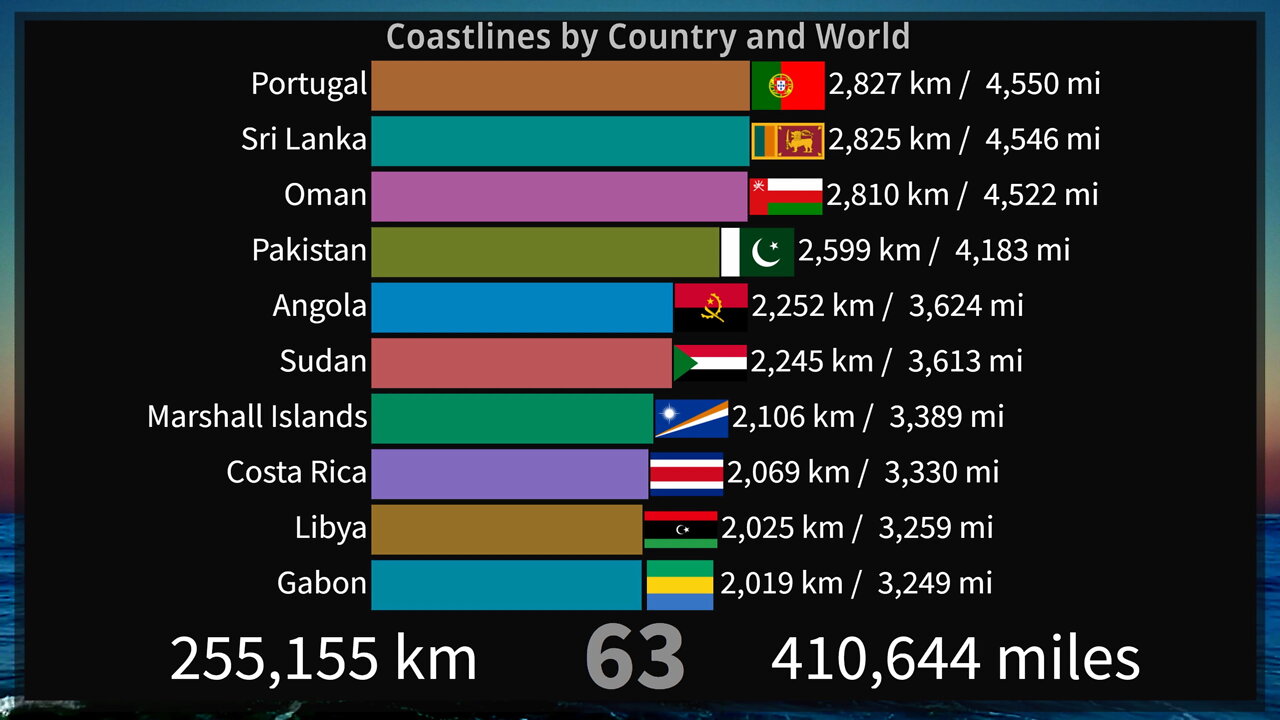
Length of Coastlines by Country and World
This bar chart show the approximated length of coastlines by country (top 100) and the world, in kilometers and miles, derived from World Vector Shoreline database at 1:250,000 scale.
The methodology used to estimate length is based on the following: 1) A country's coastline is made up of individual lines, and an individual line has two or more vertices and/or nodes. 2) The length between two vertices is calculated on the surface of a sphere. 3) The sum of the lengths of the pairs of vertices is aggregated for each individual line, and 4) the sum of the lengths of individual lines was aggregated for a country. In general, the coastline length of islands that are part of a country, but are not overseas territories, are included in the coastline estimate for that country (i.e., Canary Islands are included in Spain). Disputed areas are not included in country or regional totals.
Caspian Sea is included as part of coastlines, thus countries like Uzbekistan and Kazakhstan are not considered landlocked.
Macau and Hong Kong are included in China, but not Taiwan.
The world counter includes all coastlines.
Sources:
World Vector Shoreline, United States Defense Mapping Agency, Figures were calculated by L. Pruett and J. Cimino, unpublished data, Global Maritime Boundaries Database (GMBD), Veridian - MRJ Technology Solutions, (Fairfax, Virginia, January, 2000).
Music:
Rainswept - T.I.D.E.
https://soundcloud.com/rainsweptmusic/tide
T.I.D.E. By Rainswept is licensed under a Creative Commons License. https://creativecommons.org/licenses/by-sa/3.0/
Special Effect by:
AA VFX: https://www.youtube.com/c/dvdangor2011/
-
 3:40:50
Diony5usgaming
3 hours agoDiony komidi zeigan +iamnibz + wolfblade
12.4K3 -
 20:20
20:20
Anthony Pompliano
14 hours ago $16.33 earnedWhy Smart Money Is Going All In On Bitcoin
28.5K3 -
 14:10
14:10
Dr. Nick Zyrowski
2 months agoThe AMAZING Health Benefits of NAC ( N-Acetyl Cysteine)
23.2K18 -
 5:14
5:14
Gamazda
1 month ago $6.42 earnedWhat Happens When You Mix Piano & Xylophone? Canon in D Like Magic!
34.7K41 -
 13:54
13:54
Mama to Five
17 hours ago $2.98 earnedWHAT I EAT IN A DAY! | FULL DAY OF MEALS AS A MOM OF 5
31.8K6 -
 1:01:18
Futures Edge: Finance Unfiltered with Jim Iuorio and Bob Iaccino
1 day ago $19.73 earnedLIVE Technical Analysis with Mike Arnold
82K3 -
 4:56
4:56
SLS - Street League Skateboarding
6 days agoDay in the Life of Pro Skateboarder Mariah Duran | Part 2
24.8K4 -
 14:32
14:32
Chubbyemu
2 days agoA Woman Drank 1 Liter Soy Sauce Colon Cleanse In 2 Hours. This Is What Happened To Her Brain.
38.6K16 -
 2:57:55
FreshandFit
8 hours agoAfter Hours w/ Girls
97.1K56 -
 22:23
22:23
Neil McCoy-Ward
18 hours agoThe Middle Class Just Collapsed...
25.3K14