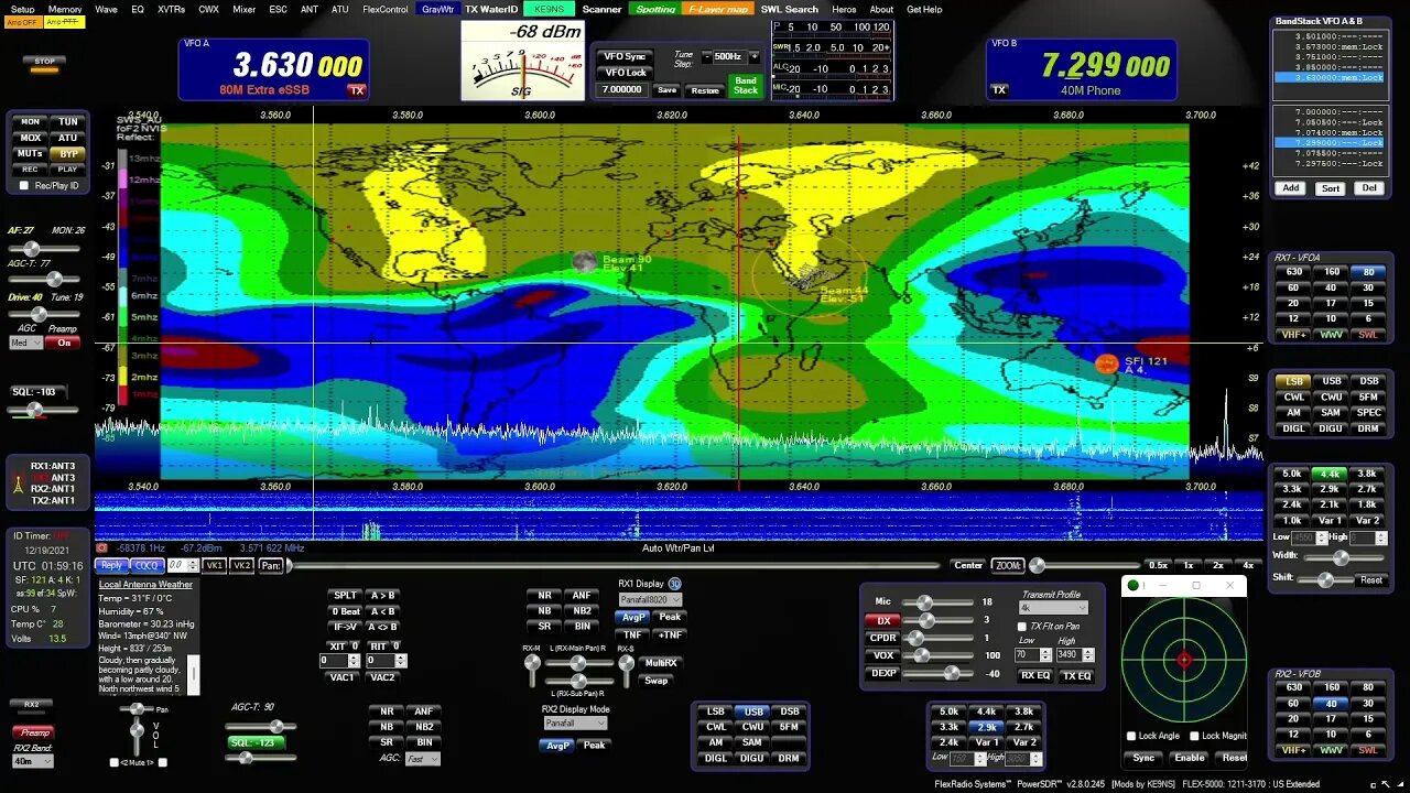
Maps of PowerSDR ke9ns v2.8
0:00 - Hold you mouse over the PowerSDR console "Maps" menu item and hit F1 to get a help window:
LEFT CLICK: SPOTTER TRACKING WORLD Map with Grayline, Sun-Moon Tracking, ISS, DX Spots, VOACAP
WHEEL CLICK: Opens separate Callsign prefix Map window
RIGHT CLICK: Toggles F-Layer, D-Layer, Lightning, Cloud cover Maps ON/OFF (Described below)
----------------------------------------------------------
0:44 - SPOTTER MAP provided by NOAA (see SPOTTER screen)
Shows World map with (SHIFT key) LAT/LONG, Day indicator, and optional Grayline, Sun, Moon, ISS
Shows Clickable (RED) spots directly on map (CTRL key goes directly to Spot Frequency)
Grid lines represent Lat, Long and +/- hours from UTC
VOACAP feature
----------------------------------------------------------
2:11 - F-LAYER MAP provided by: Australian gov space weather service critical foF2-Layer world map. (Updated every 30min)
Colors denoting the highest frequency the f2 ionosphere will reflect vertical directed signals directly back towards earth (NVIS)
Determined using ionosonde radar. The higher the reflect frequencies, the more open propagation will be in those areas.
If your station is under a Blue (or better) area on the F2 map,
you may experience skip conditions on or close to 10m to other Blue (or better) areas of the F2 map.
Red up to Blue usually indicates that the uppers bands are closed.
----------------------------------------------------------
3:28- D-LAYER MAP provided by: NOAA XRAY D-Layer Absorption level world map.
Absorbs Low Band RF in the D-Layer during daylight hours (and X-Ray events)
Higher frequencies can pass through the D-Layer up to the E/F-Layers unless shown on this map.
If you see a Space Weather report of "Radio Blackout", check for D-Layer absorption
----------------------------------------------------------
4:13 - LIGHTNING MAP provided by: Blitzortung
Real-Time but updated every 30 min
White = Recent Lighting strike (within 20 min)
Yellow = (within 40min)
Red = Very Old (within 120min)
HOLD CTRL+Z to Zoom or Magnify an area next to the Mouse on the Map.
----------------------------------------------------------
4:48 - CLOUD COVER MAP (Mosaic) Provided by: University of Wisconsin-Madison
Real-Time but updated every 30 min
Mosaic IR Cloud cover for most of the Earth
Note: No cloud data for lower center section of world map.
HOLD CTRL+Z to Zoom or Magnify an area next to the Mouse on the Map.
Download from my website at: ke9ns.com/flexpage.html
Darrin
ke9ns
-
 LIVE
LIVE
Side Scrollers Podcast
1 day ago🔴SIDE SCROLLERS FUND-A-THON🔴DAY 1🔴100% REVENUE HELPS CHANGE CULTURE!
1,286 watching -

Barry Cunningham
4 hours agoPRESIDENT TRUMP HAS A MAJOR WIN AND HIS TEAM IS ABSOLUTELY UNLEASHED!
67912 -
 DVR
DVR
Flyover Conservatives
21 hours agoThe Agenda Behind No Kings — They Lied. They Funded It.; Silver Explosion FAR from Over, PhD Explains What’s Next and Why! - Dr. Kirk Elliott | FOC Show
4.53K -
 LIVE
LIVE
We Like Shooting
13 hours agoWe Like Shooting 633 (Gun Podcast)
131 watching -
 1:32:29
Glenn Greenwald
5 hours agoNo Kings Protests: A Partisan Pro-DNC Circus; The Trump Admin's Escalating Strikes on "Drug Boats" and Militarization of the Caribbean | SYSTEM UPDATE #534
17.4K44 -
 LIVE
LIVE
SOLTEKGG
2 hours ago🔴LIVE - BATTLEFIELD 6 W/ SOLTEK
71 watching -
 LIVE
LIVE
VapinGamers
2 hours agoBattlefield 6 - Gettin My Body Ready for BR and Other Funzies with Friends - !rumbot !music
96 watching -
 41:43
41:43
MattMorseTV
4 hours ago🔴It’s ACTUALLY HAPPENING…🔴
3.65K73 -
 LIVE
LIVE
Putther
2 hours ago🔴LIL WILLY RETURNS TO GTA RP
128 watching -
 LIVE
LIVE
Reidboyy
8 hours agoCamo King Grinds 100% Completion for Battlefield 6 *SECRET* Mastery Camo (All Badges + Camos 100%)
10 watching