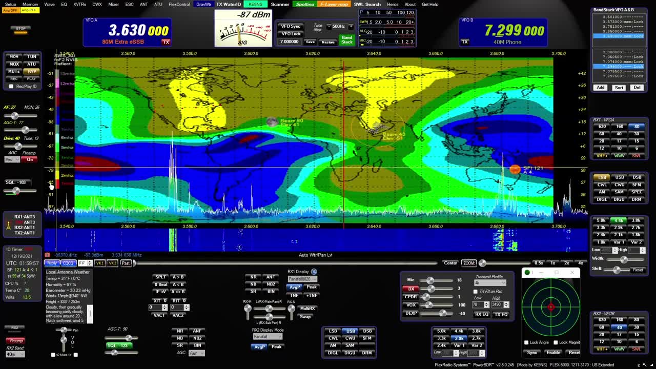
Maps of PowerSDR ke9ns v2.8
0:00 - Hold you mouse over the PowerSDR console "Maps" menu item and hit F1 to get a help window:
LEFT CLICK: SPOTTER TRACKING WORLD Map with Grayline, Sun-Moon Tracking, ISS, DX Spots, VOACAP
WHEEL CLICK: Opens separate Callsign prefix Map window
RIGHT CLICK: Toggles F-Layer, D-Layer, Lightning, Cloud cover Maps ON/OFF (Described below)
----------------------------------------------------------
0:44 - SPOTTER MAP provided by NOAA (see SPOTTER screen)
Shows World map with (SHIFT key) LAT/LONG, Day indicator, and optional Grayline, Sun, Moon, ISS
Shows Clickable (RED) spots directly on map (CTRL key goes directly to Spot Frequency)
Grid lines represent Lat, Long and +/- hours from UTC
VOACAP feature
----------------------------------------------------------
2:11 - F-LAYER MAP provided by: Australian gov space weather service critical foF2-Layer world map. (Updated every 30min)
Colors denoting the highest frequency the f2 ionosphere will reflect vertical directed signals directly back towards earth (NVIS)
Determined using ionosonde radar. The higher the reflect frequencies, the more open propagation will be in those areas.
If your station is under a Blue (or better) area on the F2 map,
you may experience skip conditions on or close to 10m to other Blue (or better) areas of the F2 map.
Red up to Blue usually indicates that the uppers bands are closed.
----------------------------------------------------------
3:28- D-LAYER MAP provided by: NOAA XRAY D-Layer Absorption level world map.
Absorbs Low Band RF in the D-Layer during daylight hours (and X-Ray events)
Higher frequencies can pass through the D-Layer up to the E/F-Layers unless shown on this map.
If you see a Space Weather report of "Radio Blackout", check for D-Layer absorption
----------------------------------------------------------
4:13 - LIGHTNING MAP provided by: Blitzortung
Real-Time but updated every 30 min
White = Recent Lighting strike (within 20 min)
Yellow = (within 40min)
Red = Very Old (within 120min)
HOLD CTRL+Z to Zoom or Magnify an area next to the Mouse on the Map.
----------------------------------------------------------
4:48 - CLOUD COVER MAP (Mosaic) Provided by: University of Wisconsin-Madison
Real-Time but updated every 30 min
Mosaic IR Cloud cover for most of the Earth
Note: No cloud data for lower center section of world map.
HOLD CTRL+Z to Zoom or Magnify an area next to the Mouse on the Map.
Download from my website at: ke9ns.com/flexpage.html
Darrin
ke9ns
-
 1:02:46
TheCrucible
2 hours agoThe Extravaganza! EP: 57 with Guest Co-Host: Rob Noerr (10/21/25)
47.3K8 -
 DVR
DVR
Redacted News
3 hours agoHIGH ALERT! TRUMP'S WAR WITH VENEZUELA IS COMING, BLACKROCK TAKES OVER ELECTRIC GRIDS
107K58 -
 LIVE
LIVE
Robert Gouveia
2 hours agoEx-CIA Brennan's Criminal Referral!! Jack Smith Caught AGAIN! Judge BLOCKS ICE Arrests!
1,355 watching -
 14:51
14:51
Rethinking the Dollar
7 hours agoSilver Price Crash? Why You’re Still Paying $60+ for Eagles
4.82K9 -
 LIVE
LIVE
The Amber May Show
3 hours agoSlacker82Alpha| SPECIAL GUEST RENOWNED UFO EXPERT STAN DEYO
122 watching -
 LIVE
LIVE
MattMorseTV
3 hours ago $5.32 earned🔴Community Hangout🔴
494 watching -
 LIVE
LIVE
Tundra Tactical
5 hours ago $2.52 earnedThe Great Tundra Nation Gaming Stream!!! Featuring ThePiggNation LAST DAY!!!!
105 watching -
 2:38:50
The Rabble Wrangler
4 hours agoThe Best in the West | Live From Rumble Studios
23.8K -
 16:55
16:55
Bearing
11 hours agoHasan Piker’s EPIC MELTDOWN 💥 F**k My Audience, F**k Streaming, F**k Socialism 🤬
14.6K21 -
 LIVE
LIVE
LFA TV
20 hours agoLIVE & BREAKING NEWS! | TUESDAY 10/21/25
766 watching