Well location surveys image the aquifer depth and yield
3 years ago
4
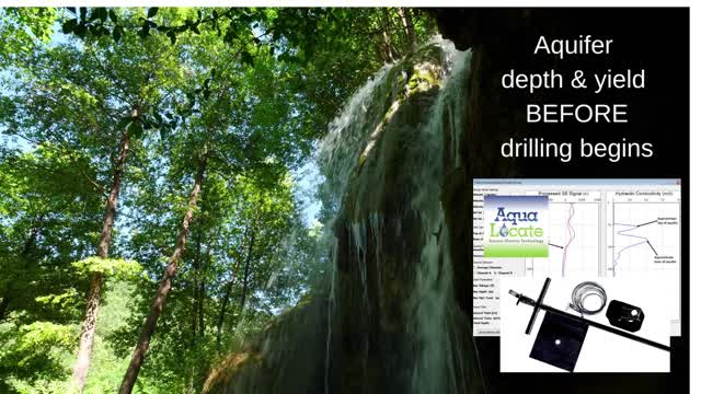
Locate the aquifer before drilling a borehole. A GF6 seismoelectric (exploration) survey images the depth and yield of your new water well and helps you plan for the drilling cost. The patented GF6 system has been used around the world successfully for over 20 years. Find out more about the GF6 instrument, groundwater location surveys (residential, commercial and agricultural) or become an independent operator by visiting www.aqualocate.com or calling 800.2512920
Loading comments...
-
 18:25
18:25
Liberty Hangout
13 days agoAnti-Ice Demonstrators Love Poop!
2.23K37 -
 13:09
13:09
Forrest Galante
7 hours agoWildlife Expert Reacts To Deadly Australian Animal TikToks
4.27K2 -
 9:39
9:39
MattMorseTV
13 hours ago $0.74 earnedVance just DROPPED a BOMBSHELL.
26K60 -
 23:47
23:47
GritsGG
1 day agoThe Forgotten Best Sniper Support AR!
2.47K2 -
 1:15:48
The Pascal Show
15 hours agoMUGSHOTS RELEASED! Emmanuel Haro's Parents Mugshot Released To The Public
1.7K -
 14:45
14:45
BlabberingCollector
18 hours agoKings Cross Station SET LEAKS! | Harry Potter HBO Show Update & News
1.69K -
 33:20
33:20
SB Mowing
9 days agoHealth Struggles + Endless Rain = A Yard Out of Control
10.2K18 -
 1:09:42
Mike Rowe
4 days agoHow Did THIS Dirty Job Make Tommy Mello A Billionaire?! | #447 | The Way I Heard It
67.9K20 -

SpartakusLIVE
10 hours agoThe BADDEST Duo in WZ Exhibits PEAK Physique || Duos w/ Sophiesnazz to start, quads later
165K1 -
 2:49:37
RattlesnakeTV
22 hours ago $0.29 earnedLIVE DEBATE! Lord Jake vs Crazy Feminist
27K13