Premium Only Content

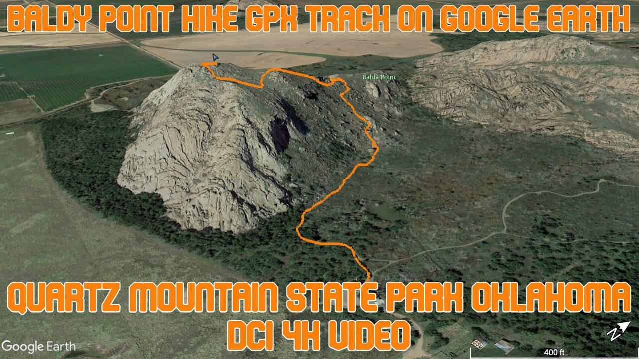
Baldy Point Hike GPX Track on Google Earth / Quartz Mountain State Park Oklahoma / DCI 4K Video
I hiked Baldy Point Trail in Quartz Mountain State Park in Oklahoma. I exported the GPX track and then added it to Google Earth. Here's the fly along of the trail and you can see the elevation change and the terrain. Enjoy!
#googleearth #oklahoma #hiking #trekking #statepark #quartzmountain #thisisoklahoma #flyalong #dci4k
**********
➡️ Welcome to Camping and Trekking, the channel that chronicles the weird and interesting places I find myself exploring in Oklahoma and beyond. At the start of this new year, I'll also be starting fresh and quitting my job to travel around this beautiful country to see and learn as much as possible. Like, subscribe, and comment to see where I end up and let me know what you like and what places you'd want to see.
➡️ Join me to see where we can land when we upend one's life and allow the journey to determine the destination.
➡️ You can also find more details about my traveling adventures at https://campingandtrekking.com and on Instagram 📸 camping_and_trekking.
Here, you can read more specific details about how to reach some of those fun, out of the way destinations that are detailed on this channel, insider tips, and important information on how to have the best experience possible while traveling to these unique landing places around the U.S. I'm always looking for your feedback and recommendations as well, so if there's a place you'd like me to visit or any questions you have, please send them my way. 💌 Thank you for looking and Happy Trails! 🏕
➡️ For more information on what led to this major life change, see my personal Youtube page thenachochip ➡️ https://www.youtube.com/channel/UChrC6Sto2O2FCmsqPN5TTiw
⚡️📬 brett@campingandtrekking.com
-
 3:19
3:19
Camping and Trekking Across the World!
2 months agoRITTERSTONE EXPLORING | Müllerstisch & Fort 5
33 -
 LIVE
LIVE
Game On!
17 hours agoCollege Football Is BACK! Week 1 Preview!
5,821 watching -
 LIVE
LIVE
The Bubba Army
22 hours agoMinneapolis Shooter Story Unfolds! - Bubba the Love Sponge® Show | 8/28/25
2,685 watching -
 LIVE
LIVE
JuicyJohns
11 minutes ago🟢#1 REBIRTH PLAYER 10.2+ KD🟢
63 watching -
 16:58
16:58
marcushouse
13 hours ago $1.62 earnedSpaceX Starship Flight 10: What Really Happened! 🚀
25.8K11 -
 3:47
3:47
Blackstone Griddles
13 hours agoCampground Meal Planning on the Blackstone Camping Griddle
4.14K1 -
 28:13
28:13
Her Patriot Voice
13 hours ago $0.63 earnedIs Flag Burning Free Speech?
11K11 -
 17:51
17:51
TheRoyaltyAutoService
15 hours ago $0.17 earnedIs Flat Rate Ruining The Auto Repair Industry?!
4.23K5 -
 LIVE
LIVE
BEK TV
23 hours agoTrent Loos in the Morning - 8/28/2025
217 watching -
 26:00
26:00
DeVory Darkins
1 day ago $11.62 earnedDemocrat Mayor HUMILIATES himself during painful interview as Trump makes SHOCKING Announcement
44.4K97