
Sunday snow & gusty winds
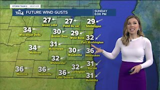
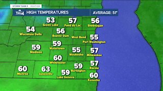
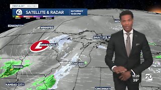
A snowy start to Sunday as showers continue to move across the area. The steadiest snow will be between 6 a.m. and 1 p.m., with a few light showers lingering through the evening. Warm ground temperatures and air temperatures a few degrees above freezing will keep accumulating snowfall light. Most locations can expect less than 1" of snow, but we could pick up 1-3" of snow in Dodge, Washington, and Fond du Lac counties by the early afternoon. Winds will pick up as the snow starts to wrap up, reducing visibility at times to a mile or even less. Winds will be northwest 15-20 mph with gusts near 40 mph. Be cautious when traveling anywhere today, especially northward. Highs will be in the mid to upper 30s. Sunday night will be dry by chilly with lows falling into the 20s to start off Monday. Clouds hang around Monday as a weak disturbance quickly moves across the area. This disturbance will likely bring a few light snow showers in the afternoon with no accumulation. Highs will be in the mid to upper 30s. Temperatures will jump back near average Tuesday and Wednesday and into the low 50s, with a few rain showers possible Wednesday.
-
 2:38
2:38
WTMJMilwaukee
1 year ago10-year-old boy headed to trial for killing mother over VR headset
8672 -
 1:14
1:14
WTMJMilwaukee
4 years agoPartly cloudy Sunday with gusty winds
7 -
 1:54
1:54
WTMJMilwaukee
4 years agoCooler temperatures and gusty winds Sunday
16 -
 3:09
3:09
KJRH
3 years agoGusty North Winds Today
2 -
 3:13
3:13
KJRH
4 years agoGusty South Winds and Light Showers for Sunday.
12 -
 1:23
1:23
Pelmorex_Eng
3 years agoGusty winds transition from rainy Sunday to clear Monday
-
 1:49
1:49
WTMJMilwaukee
3 years agoGusty winds on Tuesday night
6 -
 0:07
0:07
WCPO
3 years agoChance for Snow on Sunday
4 -
 3:04
3:04
WXYZ
3 years agoTracking snow for Sunday morning
26 -
 2:43
2:43
KGUN
4 years agoWinds blow in Sunday
21