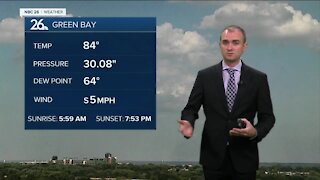
Gino Recchia NBC26 Weather Forecast
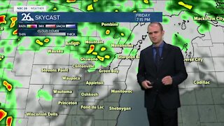
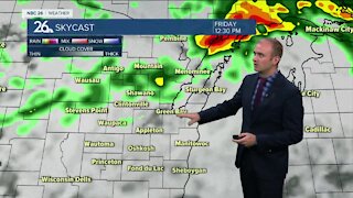
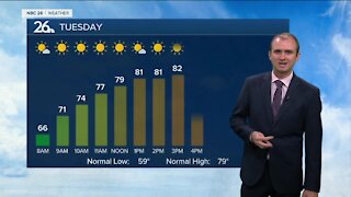
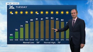
Additional showers and thunderstorms capable of severe weather are possible this into the evening. Hail, gusty winds, and localized flooding will be a problem once again. The axis of where this heavy rain will fall remains a question, but somewhere in our viewing area, there will be a likelihood of localize flooding. Saturday morning storms will wind down and high temperatures will soar to the upper 80s and even some low 90s are possible. Under partly sunny skies for the afternoon, more showers and storms return at night along a cold front, into Sunday morning. Some storms are possible Sunday as the cold front continues to move through. Highs should be cooler in the lower to mid 80s. There is a marginal risk for severe storms. Cooler weather returns next week, in the 70s with abundant sunshine.
-
 3:36
3:36
WGBA
7 months agoWill it be necessary to have both the AC & the heat on during the same day??
991 -
 2:46
2:46
WGBA
2 years agoGino Recchia NBC26 Weather Forecast
2 -
 3:01
3:01
WGBA
2 years agoGino Recchia NBC26 Weather Forecast
5 -
 2:54
2:54
WGBA
2 years agoGino Recchia NBC26 Weather Forecast
3 -
 2:41
2:41
WGBA
2 years agoGino Recchia NBC26 Weather Forecast
2 -
 3:33
3:33
WGBA
2 years agoGino Recchia NBC26 Weather Forecast
6 -
 3:58
3:58
WGBA
2 years agoGino Recchia NBC26 Weather Forecast
5 -
 2:56
2:56
WGBA
2 years agoGino Recchia NBC26 Weather Forecast
5 -
 3:07
3:07
WGBA
2 years agoGino Recchia NBC26 Weather Forecast
3 -
 2:53
2:53
WGBA
2 years agoGino Recchia NBC26 Weather Forecast
2