
Gino Recchia NBC26 Weather Forecast
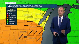
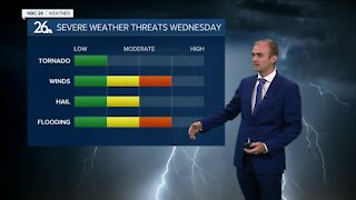
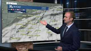
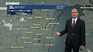
Skies will be mostly clear tonight with overnight lows in the mid 60s and light southwest winds around 5 mph. Wednesday will be a warm and humid day with highs in the mid to upper 80s. Starting the day off with sunshine, by the afternoon we transition to a risk of strong and severe thunderstorms by the afternoon and continuing through the overnight hours. Damaging winds, torrential downpours will be the primary risks, but we can't completely rule out a brief spin-up tornado along the leading edge of this line of storms. The cold front will be slowly moving through the area overnight into Thursday providing additional risks for training thunderstorms. This may result in a flooding risk for some areas with model guidance outputting inches of rainfall. Highs Thursday will be in the mid to upper 70s. Showers and storms will move out of the area by the afternoon with clearing skies working their way in from the northwest. Friday will be similar temperature wise, in the upper 70s to near 80. Skies will be sunny which will be a nice start to kick off the weekend. Several days of sunny weather are expected as we head into the weekend. Temperatures will be gradually rising into the mid to upper 80s by next week Tuesday.
-
 1:57
1:57
WGBA
1 year agoHow the City of Green Bay is hoping a $1.6M investment will make the community safer for pedestrians
3701 -
 3:28
3:28
WGBA
3 years agoGino Recchia NBC26 Weather Forecast
5 -
 3:55
3:55
WGBA
3 years agoGino Recchia NBC26 Weather Forecast
1 -
 4:16
4:16
WGBA
3 years agoGino Recchia NBC26 Weather Forecast
1 -
 3:39
3:39
WGBA
3 years agoGino Recchia NBC26 Weather Forecast
6 -
 3:22
3:22
WGBA
3 years agoGino Recchia NBC26 Weather Forecast
9 -
 3:46
3:46
WGBA
3 years agoGino Recchia NBC26 Weather Forecast
12 -
 3:49
3:49
WGBA
3 years agoGino Recchia NBC26 Weather Forecast
2 -
 3:40
3:40
WGBA
3 years agoGino Recchia NBC26 Weather Forecast
5 -
 3:21
3:21
WGBA
3 years agoGino Recchia NBC26 Weather Forecast
3