Mapping the Topography of the Ocean Floor; Underwater Volcanoes, Mountains and Valleys
5.1 Mapping the Topography of the Ocean Floor; Underwater Volcanoes, Mountains and Valleys
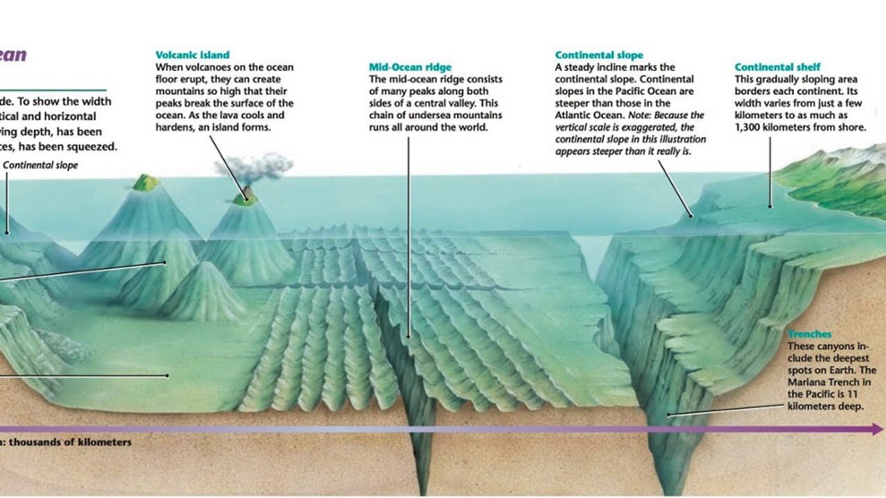
The ocean is the largest feature on Earth, covering more than 70% of our planet's surface. One of the main reasons that Wegener's continental drift hypothesis was not widely accepted when first proposed was that so little was known about the ocean floor. Until the 20th century, investigators used weighted lines to measure water depth. In deep water these depth measurements, or soundings, took hours to perform and could be wildly inaccurate.
With the development of new marine tools following World War II, our knowledge of the diverse topography of the ocean floor grew rapidly. One of the most interesting discoveries was the global oceanic ridge system. This broad elevated landform which stands two to three kilometers above the adjacent deep ocean basins, is the longest topographic feature on Earth.
Today we know that oceanic ridges mark divergent plate margins, where new oceanic lithosphere originates. We also know that deep ocean trenches represent convergent plate boundaries, where oceanic lithosphere is subducted into the mantle. Because the process of plate tectonics is creating oceanic crust at mid-ocean ridges and consuming it at subduction zones, the oceanic crust is continually being renewed and recycled.
-
 0:13
0:13
tarunrr
4 years agoUnderwater Ocean Footage
37 -
 0:45
0:45
Amazing Ocean
4 years agoBeautiful underwater dwellers | Amazing Ocean Discoveries
136 -
 1:08:29
TheCrucible
3 hours agoThe Extravaganza! Ep. 24 (8/19/25)
62.7K14 -
 4:22:25
sophiesnazz
5 hours agoLETS TALK ABOUT BO7 !socials !specs
3.18K -
 1:27:30
Redacted News
4 hours ago"There will be consequences!!!" Trump issues big threat to Putin ahead of peace summit | Redacted
86.8K147 -
 LIVE
LIVE
Amish Zaku
2 hours agoWar Thunder - Tank Tuesday
90 watching -
 1:27:05
Kim Iversen
4 hours agoIsrael DEMANDS X Remove Posts and X COMPLIES | Socialist Groceries Coming To A Store Near You!
40.9K97 -
 1:11:53
vivafrei
11 hours agoThe Great Replacement of American Truckers With Unskilled Foreign Labor - Live with Gord Magill
93.5K64 -
 1:05:13
Sarah Westall
4 hours agoEU Falling, United States Barely Hanging on - Strength and Courage Needed to Fight for Free Speech
39.1K5 -
 LIVE
LIVE
LFA TV
13 hours agoLFA TV ALL DAY STREAM - TUESDAY 8/19/25
811 watching