Premium Only Content

Plane flies around funnel cloud
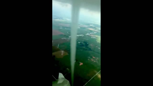
Oklahoma glider pilot flies around landspout tornado
Pilot David T. Evans got up close and personal with a funnel cloud Sunday in western Oklahoma.
Oklahoma City native David Evans has been a pilot for about 30 years, but few things compare with what he encountered while flying his glider Sunday. Evans came face to face with a bona fide tornado — and decided to hitch a ride on the upward-moving air around it.
While Green Country was dry, western Oklahoma dealt with scattered severe thunderstorms in the afternoon and evening. There was enough wind shear (rotation) present in the atmosphere to form the funnel.
Evans' wife told 2 News he was flying between Minco and Tuttle, which is southwest of Oklahoma City. No word yet from the National Weather Service Office in Norman if it ever touched the ground, which would officially make it a tornado.
The storm system later moved south into north Texas during the evening and dissipated.
Weather wasn’t conducive for strong thunderstorm activity or tornadoes in the Sooner State on Sunday, but Evans found a landspout, a borderline tornado that forms in a way similar to many waterspouts or dust devils. That meant it wasn’t born from a thunderstorm or cloud-based rotation, but rather developed from the ground up.
It also couldn’t be spotted on radar, and there were no obvious large-scale weather features that would have clued meteorologists in to the chance for tornadoes.
Realistically, it was more of a landspout, but we sort of have no justification as to why it occurred,” said Ryan Bunker, a meteorologist at the National Weather Service in Norman, Okla. “We didn’t have any answers.”
Instead, it appears that a small, broad surface-based whirl cooked up in the heat of the afternoon sun — as is routine during the summertime.
“I have a little motorglider, and you look for these thermals to stay aloft,” said Evans, who hadn’t been optimistic about the day’s gliding prospects. He took off from Wiley Post Airport on the northwest side of Oklahoma City anyway, hoping to get lucky.
“I motored around Tuttle and Minco, and then I saw some hawks,” Evans recalled. “They’re always a telltale sign of where a thermal might be. I started getting an indication I was getting lift, so I circled in there with them.”
The broad, weak, invisible circulation that Evans was riding quickly became drawn into a cloud developing overhead. That stretched it up to the cloud base, causing it to become more narrow and to strengthen. Before long, a funnel cloud appeared.
The thermal] was raising me up at about 100 or 200 feet per minute,” Evans said. “Then all of a sudden that vapor funnel started forming. It was going down and down and down, but there was no turbulence. I just kept flying around that thing.”
It was unclear to Evans at the time, but apparently the funnel did have a ground circulation attached to it — making it a tornado, albeit a weak one. Winds were probably less than 75 mph, but it did stir up vegetation and hay on the property of Judy Curry.
That would make it an official tornado, similar in formative processes to the picturesque funnel that danced east of Denver last week.
“It was really pretty,” Evans said. “It went from base of clouds … it was a rat’s-tail-looking thing.”
Back at the National Weather Service, Bunker was equally impressed.
“I’ve seen cool drone footage, but you never see someone in their own plane flying right next to a funnel,” he said.
Bunker’s hypothesis is that there was a residual weak boundary of some sort draped across the area, sufficient to enhance low-level spin. That might have helped a tiny whirlwind form while also initiating upward-growing clouds above.
“You can stretch it and get a brief spin-up,” Bunker said.
In the meantime, Evans says he’s looking forward to taking to the air again soon — but doubts he’ll see anything so spectacular.
“I’ve never seen anything like that,” he said.
-
 0:45
0:45
Pelmorex_Eng
3 years agoFunnel cloud appears around Quebec neighbourhood
10 -
 0:33
0:33
KJRH
3 years agoVIDEO: Funnel cloud
3.81K -
 0:10
0:10
jojobeee
4 years agoAwesome funnel cloud
79 -
 0:37
0:37
Pelmorex_Eng
3 years agoOminous funnel cloud pops from the stormy skies over Quebec
33 -
 1:12
1:12
Bestfreemoviefinderdotcom
4 years agoAF2 - Air Force 2 plane flies into Vandenberg
4355 -
 0:12
0:12
Plaskon
4 years ago $0.03 earnedThe plane flies over the beach
141 -
 1:02
1:02
itsamegaming
4 years agoHaha funnel cloud go brrrr
72 -
 LIVE
LIVE
IsaiahLCarter
2 hours agoApostate Radio #011: The Revealing of Julie Behling
1,247 watching -
 2:08:20
George Galloway
13 hours agoRESURRECTION - MOATS with George Galloway - EP 440
44.2K57 -
 4:50
4:50
The Rubin Report
2 days agoDems Won’t Want to Hear Bill Maher’s Dark Prediction for the Democratic Party
89.1K103