Satellite Navigation Accuracy
The Prague-based European Global Navigation Satellite System Agency (GSA) has commissioned RUAG Space to conduct a study to increase real-time satellite navigation accuracy.
“The more accurately the satellite’s position can be determined, the more precise the environmental data it collects and provides. With the more accurate data, for example, the danger to coastal cities such as Venice can be predicted more effectively.”
Fiammetta Diani, Head of Market Development at GSA.
For climate and environmental research, satellites provide extremely important data every day, such as how high sea levels are rising or what effects global warming is having on glacier ice shrinkage in the Alps.
The new study, funded by a one-million Euro ($1.2 million) GSA contract, aims to further increase the accuracy of this space data from climate and environmental satellites.
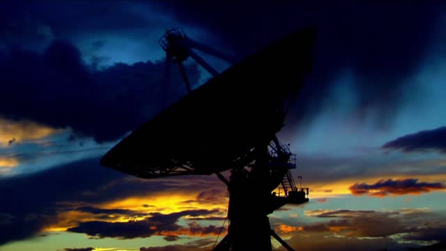
To provide precise Earth observation data from space, the satellite’s position in space must be known as accurately as possible.
To determine the exact position of satellites, RUAG Space’s satellite navigation receivers today use the signals from the 22 European Galileo navigation satellites.
“Currently, there is still untapped potential in the Galileo satellites.
They transmit several signals.
On one of these signals, a new service, the High Accuracy Service (HAS), will support significantly improved positioning from 2022,” said Martin Auer, who is leading the study at RUAG Space.
“When this new service goes into operational use, it will need equipment that can do something with it.
That’s what we’re working on.”
By the end of 2022, RUAG Space will develop a new product in Vienna that will be able to use the new Galileo HAS service.
However, navigation receivers from RUAG Space that process Galileo signals already ensure precise positioning.
These include the Sentinel-6 environmental satellite, which has been in space since November 2020.
It measures the amount of sea level change and provides crucial data on coastal areas at risk from sea level rise.
“The more accurately the satellite’s position can be determined, the more precise the environmental data it collects and provides.
With the more accurate data, for example, the danger to coastal cities such as Venice can be predicted more effectively,” said Fiammetta Diani, Head of Market Development at GSA.
RUAG Space is developing a software update for satellite navigation receivers of the current PODRIX receiver generation already in space, such as those used for Sentinel-6.
This will enable these receivers to increase the satellite navigation accuracy from the current level of about one meter (3.2 feet) to 20 centimeters (8 inches).
“This is a dramatic improvement – a quantum leap – in accurate satellite positioning that will contribute to much better climate and environmental data,” said Heinz Reichinger, the product manager responsible at RUAG Space.
-
 2:54:58
CAMELOT331
7 hours agoYouTube Just Told Me I OWE THOUSANDS $ TO THEM... update
30.9K5 -
 2:00:53
Tundra Tactical
14 hours ago $1.95 earned🛑LIVE AT 9PM CST!! Your Government Hates Your Guns : DOJ Holds Firm On National FIREARMS ACT
18.2K -
 2:44:56
DLDAfterDark
4 hours ago $3.20 earnedAre YOU The Guy That Ruins Thanksgiving?? - God Guns & Gear
24.9K -
 2:58:31
NewsTreason
6 hours agoDECLAS w/ Rambo & Dave: Nuremberg 2.0 | MTG Exits Stage Left | Mamdani Psyop Confirmed, 8pm EST
68.5K68 -
 LIVE
LIVE
meleegames
6 hours agoSONG REQUESTS CLOSED - Melee Music - Beat Hazard 3 - Devil Inside
129 watching -
 2:13:31
The Connect: With Johnny Mitchell
13 hours ago $3.28 earnedIs Garth Brooks A Serial Killer? Exposing The Dark Secrets Of Country Music's Biggest Star
15K4 -
 1:00:49
MattMorseTV
7 hours ago $89.26 earned🔴Massive VICTORY in the SUPREME COURT.🔴
103K138 -
 4:08:14
GritsGG
5 hours ago#1 Most Warzone Wins 4015+!
14.9K -
 4:20:08
Biscotti-B23
9 hours ago $1.07 earned🔴 LIVE STREAM ENDS WHEN I GET 100 WINS 🥵 INVINCIBLE VS CLOSED ALPHA
12.5K3 -
 12:38
12:38
Timcast
1 day agoJasmine Crocket HUMILIATED By CNN To HER FACE Over Epstein LIE | Tim Pool
112K77