NBC 26 weather forecast
3 years ago
3
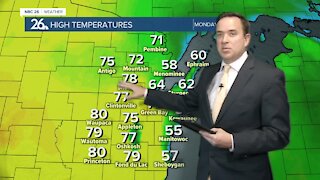
Monday was the warmest day since September with highs in the upper 70s to lower 80s. Green Bay had a record high of 77. Highs will range from the 50s near Lake Michigan to the lower 80s well inland Tuesday & Wednesday. There will be a slight chance of isolated showers or thunderstorms arriving late tonight and into early Tuesday morning. Several additional rounds of precipitation will soak us through the upcoming week, as several areas of low pressure pass through the area. Temperatures will also be cooling off widespread into the 50s by the end of the work week, but still are above average.
Loading comments...
-
 0:30
0:30
WGBA
7 months agoThree Degree Guarantee
61 -
 3:18
3:18
WGBA
3 years agoNBC 26 weather forecast
3 -
 3:34
3:34
WGBA
3 years agoNBC 26 weather forecast
8 -
 3:30
3:30
WGBA
3 years agoNBC 26 weather forecast
10 -
 4:34
4:34
WGBA
3 years agoNBC 26 weather forecast
3 -
 3:43
3:43
WGBA
3 years agoNBC 26 weather forecast
11 -
 2:51
2:51
WGBA
3 years agoNBC 26 Weather Forecast
5 -
 3:24
3:24
WGBA
3 years agoNBC 26 weather forecast
4 -
 4:06
4:06
WGBA
3 years agoNBC 26 weather forecast
17 -
 3:18
3:18
WGBA
3 years agoNBC 26 weather forecast
2