NBC 26 weather forecast
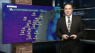
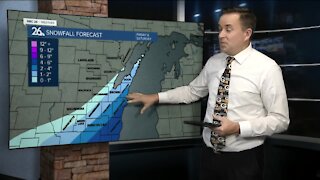
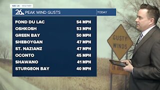
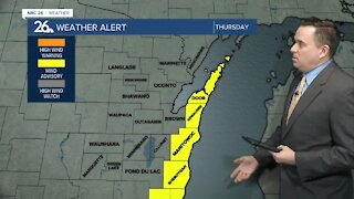
We are kicking off this Monday morning with temperatures in the upper 40s and low 50s! What a way to start the week off! Winds have calmed down compared to yesterday, but still breezy out of the southwest up to 25mph. Expect mostly cloudy skies today with chances of an isolated shower this evening. Highs will be in the upper 50s, while away from the lake, you'll climb to the mid 60s! Soak up the well above average temperatures now, because cooler air moves in behind the rain that's targeting us on Tuesday and Wednesday. Behind that system, cooler air funnels in and Thursday our temperatures crash throughout the day and into the 20s by Friday morning. Highs behind that, will be in the upper 30s to low 40s. Since our overnight lows will be back below freezing Thursday and Friday night, we can't rule out a chance of a wintry mix Friday. One model even hints at some accumulating snow. We will be keeping a close eye on this and fine tune the forecast for you as the system gets closer. This weekend we can expect the sunshine to return, with near average temperatures in the mid 40s. Long range temperature forecasts are keeping highs closer to average by the end of March. The average high temperature by the end of the month is 46.
-
 3:36
3:36
WGBA
8 months agoWill it be necessary to have both the AC & the heat on during the same day??
991 -
 4:06
4:06
WGBA
3 years agoNBC 26 weather forecast
17 -
 0:38
0:38
WGBA
3 years agoNBC 26 weather forecast
13 -
 3:42
3:42
WGBA
3 years agoNBC 26 weather forecast
2 -
 4:03
4:03
WGBA
3 years agoNBC 26 weather forecast
2 -
 3:38
3:38
WGBA
3 years agoNBC 26 weather forecast
3 -
 3:38
3:38
WGBA
3 years agoNBC 26 weather forecast
3 -
 3:06
3:06
WGBA
3 years agoNBC 26 weather forecast
3 -
 3:37
3:37
WGBA
3 years agoNBC 26 weather forecast
7 -
 3:52
3:52
WGBA
3 years agoNBC 26 weather forecast
2