NBC 26 weather forecast
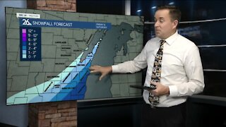
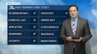
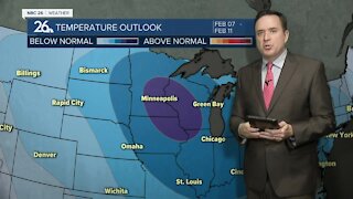
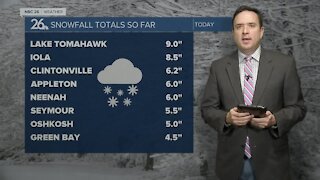
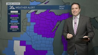
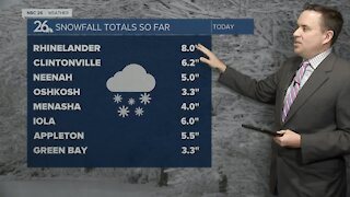
A storm system will pass south of the area tonight, however with northeast winds picking up, this will create an opportunity for lake effect snow along the immediate shorelines of southern Kewaunee county through Manitowoc, and down into Sheboygan County. The band of snow looks to just scrape the shoreline, so inland areas probably won't see a thing. How much snow along the shore will all be dependent on how far onshore this band sets up. Totals could range from as little as 1-2 inches to locally 6-9"+. Lake effect snow showers will taper off by Tuesday afternoon. For the rest of the area on Tuesday, temperatures will climb into the mid to upper teens with partly cloudy skies. The 20s are back on Wednesday, the first time since the 5th of the month (12 days of temperatures below 20). Another winter storm appears to develop across the southern Midwest and Great Lakes on Thursday with a track south of our area mainly, but some light snow showers are possible. Highs will be in the mid 20s. Highs rise to close to 30 degrees by Sunday.
-
 1:45
1:45
WGBA
11 months agoStudents excited to start at "huge and beautiful" Vel Phillips Middle School
193 -
 4:06
4:06
WGBA
3 years agoNBC 26 weather forecast
17 -
 0:38
0:38
WGBA
3 years agoNBC 26 weather forecast
13 -
 0:43
0:43
WGBA
3 years agoNBC 26 weather forecast
18 -
 0:36
0:36
WGBA
3 years agoNBC 26 weather forecast
14 -
 3:38
3:38
WGBA
3 years agoNBC 26 weather forecast
4 -
 3:58
3:58
WGBA
3 years agoNBC 26 weather forecast
11 -
 3:51
3:51
WGBA
3 years agoNBC 26 weather forecast
5 -
 4:46
4:46
WGBA
3 years agoNBC 26 weather forecast
7 -
 4:46
4:46
WGBA
3 years agoNBC 26 weather forecast
5