Michael Fish's NBC 26 weather forecast
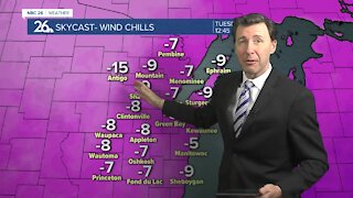
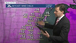
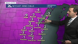
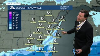
We won't warm up much today with highs in the single digits and blustery winds. A storm system will pass south of the area tonight, however with northeast winds picking up, this will create an opportunity for lake effect snow along the immediate shorelines of southern Kewaunee county through Manitowoc, and down into Sheboygan County. The band of snow looks to just scrape the shoreline, so inland areas probably won't see a thing. How much snow along the shore will all be dependent on how far onshore this band sets up. Totals could range from as little as 1-2 inches to locally 3-6. Lake effect snow showers will taper off by Tuesday evening. For the rest of the area on Tuesday, temperatures will climb into the mid to upper teens with partly cloudy skies. The 20s are back on Wednesday, the first time since the 5th of the month (12 days of temperatures below 20).
-
 3:36
3:36
WGBA
11 months agoWill it be necessary to have both the AC & the heat on during the same day??
2141 -
 1:47
1:47
WGBA
3 years agoMichael Fish's NBC 26 weather forecast
3 -
 2:08
2:08
WGBA
3 years agoMichael Fish's NBC 26 weather forecast
26 -
 1:52
1:52
WGBA
3 years agoMichael Fish's NBC 26 weather forecast
5 -
 1:39
1:39
WGBA
3 years agoMichael Fish's NBC 26 weather forecast
8 -
 1:44
1:44
WGBA
3 years agoMichael Fish's NBC 26 weather forecast
3 -
 2:46
2:46
WGBA
3 years agoMichael Fish's NBC 26 weather forecast
5 -
 2:30
2:30
WGBA
3 years agoMichael Fish's NBC 26 weather forecast
5 -
 2:20
2:20
WGBA
3 years agoMichael Fish's NBC 26 weather forecast
14 -
 2:21
2:21
WGBA
3 years agoMichael Fish's NBC 26 weather forecast
6