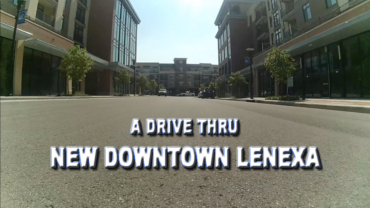
A Drive Thru New Downtown Lenexa
A drive thru the new downtown Lenexa, Kansas area.
Wikipedia:
Lenexa /lɪˈnɛksə/ is a city in Johnson County, Kansas, United States. It is the 8th most populated city in the Kansas City Metropolitan Area.[6] As of the 2010 census, the population was 48,190 with a 2019 estimate of 55,625; growing by 15.4%.[7][8] It is the birthplace of Garmin, the regional headquarters of Kiewit Construction and the former headquarters of Applebee’s[9][10][11] It is bordered by the cities of Shawnee to the north, Overland Park to the east, De Soto to the west and Olathe to the south.
Twelve years before the town of Lenexa was platted, James Butler Hickok staked a claim on 160 acres (65 ha) at what is now the corner of 83rd and Clare Road.[12] Filed in 1857, the claim was not far from the Kansas River, and was 20 miles (32 km) southwest of Westport, Missouri, and the start of the Santa Fe Trail. The trail meandered through this area on its way to Santa Fe, New Mexico.
On March 22, 1858, Hickok was elected one of the first four constables of nearby Monticello Township. Later, Hickok became a scout for the Free-State Army, a sharpshooter and eventually, one of the most famous folk heroes of the American West, Wild Bill Hickok.
At about the same time as Hickok filed his claim, a census of the Shawnee Indians living in the area was being taken, and one of the residents listed was Na-Nex-Se Blackhoof. She was the widow of Chief Blackhoof, the second signer of the 1854 treaty that ceded 1,600,000 acres (650,000 ha) of the Kansas Shawnee Indian reservation to the United States government.
In 1865, the Kansas and Neosho Valley Railroad was organized to take advantage of favorable new land laws. It later changed its name to Missouri River, Ft. Scott and Gulf Railroad, and in 1869 purchased a right-of-way from C.A. Bradshaw in the area that is now Lenexa, with the stipulation that a depot be built on the property.
Bradshaw also sold 10.5 acres (4.2 ha) to Octave Chanute, a railroad civil engineer, who platted the town in 1869. Legend states that the first town name proposed was "Bradshaw", but Bradshaw modestly refused and the name "Lenexa", a derivation of the name Na-Nex-Se, the name of Shawnee Chief Thomas Blackhoof's wife, was adopted.
Lenexa is located at 38°57′53″N 94°45′34″W (38.964689, -94.759535).[13] According to the United States Census Bureau, the city has a total area of 34.45 square miles (89.23 km2), of which, 34.10 square miles (88.32 km2) is land and 0.35 square miles (0.91 km2) is water.
The median income for a household was $61,990, and the median income for a family was $76,321 (these figures had risen to $70,246 and $86,581 respectively as of a 2007 estimate)[dead link]. Males had a median income of $50,495 versus $32,166 for females. The per capita income for the city was $30,212. About 1.8% of families and 3.4% of the population were below the poverty line, including 2.9% of those under age 18 and 3.0% of those age 65 or over.
2010 census
As of the census[2] of 2010, there were 48,190 people, 19,288 households, and 13,065 families living in the city. The population density was 1,413.2 inhabitants per square mile (545.6/km2). There were 20,832 housing units at an average density of 610.9 per square mile (235.9/km2). The racial makeup of the city was 84.4% White, 5.8% African American, 0.4% Native American, 3.8% Asian, 0.1% Pacific Islander, 3.0% from other races, and 2.5% from two or more races. Hispanic or Latino of any race were 7.3% of the population.
There were 19,288 households, of which 33.7% had children under the age of 18 living with them, 55.3% were married couples living together, 9.0% had a female householder with no husband present, 3.4% had a male householder with no wife present, and 32.3% were non-families. 25.2% of all households were made up of individuals, and 7.3% had someone living alone who was 65 years of age or older. The average household size was 2.48 and the average family size was 3.00.
The median age in the city was 36.6 years. 24.7% of residents were under the age of 18; 8.3% were between the ages of 18 and 24; 28.2% were from 25 to 44; 28.5% were from 45 to 64; and 10.3% were 65 years of age or older. The gender makeup of the city was 48.7% male and 51.3% female.
2000 census
As of the U.S. Census in 2000,[4] there were 40,238 people, 15,574 households, and 10,559 families living in the city. The population density was 1,173.8 people per square mile (453.2/km2). There were 16,378 housing units at an average density of 477.8 per square mile (184.5/km2). The racial makeup of the city was 89.50% White, 6.50% Black or African American, 0.38% Native American, 3.63% Asian, 0.03% Pacific Islander, 1.60% from other races, and 1.61% two or more races. Hispanic or Latino of any race were 3.97% of the population. 24.8% were of German, 12.4% English, 12.1% Irish and 7.2% American ancestry.
There were 15,574 households, out of which 35.1% had children under the age of 18 living with them, 57.4% were married couples living together, 7.6% had a female householder with no husband present, and 32.2% were non-families. 24.3% of all households were made up of individuals, and 5.8% had someone living alone who was 65 years of age or older. The average household size was 2.54 and the average family size was 3.08.
In the city, the population was spread out, with 25.7% under the age of 18, 9.5% from 18 to 24, 32.0% from 25 to 44, 24.2% from 45 to 64, and 8.6% who were 65 years of age or older. The median age was 35 years. For every 100 females, there were 95.8 males. For every 100 females age 18 and over, there were 93.1 males.
-
 0:31
0:31
Argyle302
4 years agoDowntown Lenexa Train
45 -
 8:15
8:15
Argyle302
4 years agoA Downtown OP Drive
24 -
 5:20
5:20
Ray26
4 years agoDrive thru Langley, WA
118 -
 1:00
1:00
mybonyfingerurchest
4 years agoDrive thru nevada
911 -
 1:00
1:00
WFTX
4 years agoGuadalupe Center present drive thru
23 -
 1:00
1:00
ViralHog
5 years ago $0.02 earnedShocking Drive Thru Experience
182 -
 6:42
6:42
Argyle302
4 years agoA Walk Thru Downtown Overland Park Kansas
239 -
 0:43
0:43
KIVI
4 years agoSt. Luke's Drive Thru Job Fair
7 -
 0:18
0:18
Unikue84
4 years agoWalk up drive thru
56 -
 1:02
1:02
ViralHog
4 years ago $0.03 earnedExtremely Rude Drive Thru Employee
135