Flurries then a littler warmer
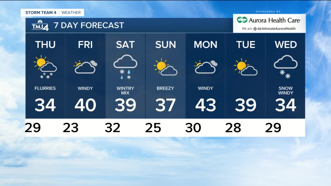
It is another cloudy day with scattered flurries, especially near the lakefront and highs near freezing. We stay cloudy tonight with a few flurries and lows near 30 in Milwaukee to 2o inland. The wind is light and will remain light on Thursday with more clouds flurries and highs in the low to mid 30s. A southerly wind kicks up on Friday to 30 mph and the sun returns helping us warm to 40. Places that have snow will see a lot of it melt. Clouds return on Saturday with a cold rain and sleet changing to light snow later in the day. High temps will be in the upper 30s and snow accumulations will be less than 1". Sunday is sunny and breezy with highs in the upper 30s. The mild weather starts next week with a high of 43 on Monday and 40 on Tuesday. Right now snow looks likely for next Wednesday...stay tuned. STORM TEAM 4CAST 4pm 12/16/20 HERE'S YOUR LATEST STORM TEAM WEATHER FORECAST FOR MILWAUKEE AND SOUTHEASTERN WISCONSIN BY BRIAN GOTTER TONIGHT: Cloudy and frosty with scattered flurries Low: 29 Lakefront...18 Inland Wind: Light THURSDAY: Mostly cloudy with scattered flurries High: 34 Wind: NE 5-10 mph FRIDAY: Partly cloudy, windy and warmer High: 40 Wind: S 15-25 mph SATURDAY: Cloudy with rain/snow mix High: 39 Wind: WNW 5-10 mph SUNDAY: Partly cloudy and breezy High: 37 Wind: SW 10-15 mph MONDAY: Mostly sunny, windy and mild High: 43 Wind: SW 15-30 mph
-
 2:38
2:38
WTMJMilwaukee
1 year ago10-year-old boy headed to trial for killing mother over VR headset
7792 -
 2:55
2:55
KJRH
4 years agoWarmer Temperatures
8 -
 2:47
2:47
KJRH
4 years agoWarmer Tuesday
27 -
 1:55
1:55
WXYZ
4 years agoFlurries then a weekend mix
7 -
 3:01
3:01
KJRH
4 years agoWarmer Wednesday
27 -
 2:34
2:34
KJRH
4 years agoWarmer Tuesday
22 -
 2:37
2:37
WXYZ
4 years agoWarmer tomorrow
32 -
 1:10
1:10
WXYZ
4 years agoWarmer weekend
43 -
 2:15
2:15
KJRH
4 years agoWarmer Wednesday
23 -
 2:49
2:49
KJRH
4 years agoWarmer Tuesday
20