Gino Recchia NBC26 Weather Forecast
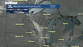
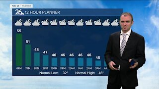
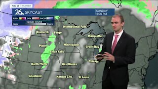
Today marked the 4th straight day of record breaking high temperatures in Green Bay. It was the 5th day of tying or breaking high temperatures. Today will be the last day because a very strong cold front is moving through as we speak Rainfall begins late tonight with mild temps in the upper-50s under breezy southwest winds at 10 to 20 mph. They will turn to the northeast overnight. Temperatures will be falling throughout the day Tuesday so morning temperatures will be in the lower 50s. Afternoon temperatures will be down into the upper 40s. Winds will remain breezy out of the northeast between 10 to 20 mph. Showers and thunderstorms are expected during the day with rainfall totals expecting to be between a 0.5 -1.5 inches, so some locally heavy downpours will be possible. Sunshine returns Wednesday, however it will be a cool day with highs in the mid 40s. Another storm system is expected to move into the Midwest next weekend bringing another chance of some rain showers.
-
 3:36
3:36
WGBA
7 months agoWill it be necessary to have both the AC & the heat on during the same day??
991 -
 3:25
3:25
WGBA
3 years agoGino Recchia NBC26 Weather Forecast
7 -
 2:46
2:46
WGBA
3 years agoGino Recchia NBC26 Weather Forecast
6 -
 4:29
4:29
WGBA
3 years agoGino Recchia NBC26 Weather Forecast
12 -
 2:33
2:33
WGBA
3 years agoGino Recchia NBC26 Weather Forecast
5 -
 3:14
3:14
WGBA
3 years agoGino Recchia NBC26 Weather Forecast
9 -
 3:15
3:15
WGBA
3 years agoGino Recchia NBC26 Weather Forecast
5 -
 3:25
3:25
WGBA
3 years agoGino Recchia NBC26 Weather Forecast
12 -
 3:24
3:24
WGBA
3 years agoGino Recchia NBC26 Weather Forecast
3 -
 3:41
3:41
WGBA
3 years agoGino Recchia NBC26 Weather Forecast
41