
NBC 26 weather forecast
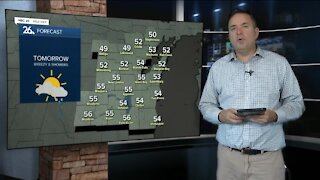
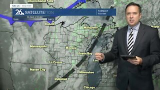
As another cold front dives south through Wisconsin, cold air will be reinforced across the area as we head into the weekend. Today, we can expect a few showers with temperatures in the lower to mid 50s. It won’t be as windy as yesterday, though northwest winds may gust to 20 mph at times. Tonight, skies should begin to clear a bit for most of the area. Further towards the Northwoods, some lake effect rain and snow showers from Lake Superior may pass over, seeing some of the first flakes of the year. With temperatures expected to be in the lower to mid 30s for many areas by Friday morning, you can expect some frost and freeze conditions. Friday will be mostly sunny, with the stray chance of a rain shower due to the lake effect. High temperatures will be near 50. Another round of frost and freeze conditions will return Friday night into Saturday morning with lows once again in the lower to mid 30s. Temperatures will climb to near 50 Saturday with mostly cloudy skies and a chance of some light rain showers from an area of low pressure that’s expected to track across Northern Illinois. Some rain showers may linger into Sunday. Warmer weather returns as we turn the page to next week. Highs will climb back into the 60s.
-
 0:30
0:30
WGBA
1 year agoThree Degree Guarantee
369 -
 3:16
3:16
WGBA
4 years agoNBC 26 weather forecast
11 -
 4:01
4:01
WGBA
5 years agoNBC 26 weather forecast
10 -
 3:22
3:22
WGBA
4 years agoNBC 26 weather forecast
3 -
 3:27
3:27
WGBA
4 years agoNBC 26 weather forecast
2 -
 4:04
4:04
WGBA
4 years agoNBC 26 weather forecast
-
 0:41
0:41
WGBA
4 years agoNBC 26 weather forecast
9 -
 3:11
3:11
WGBA
4 years agoNBC 26 weather forecast
1 -
 3:10
3:10
WGBA
4 years agoNBC 26 weather forecast
-
 4:07
4:07
WGBA
4 years agoNBC 26 weather forecast
2