Premium Only Content
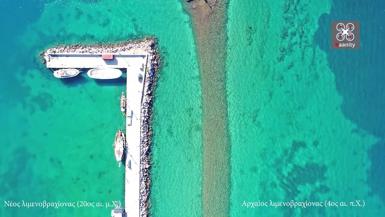
Drone footage shows two ports side-by-side, but 2,500 years apart
We bring to light the unknown sunken port of Ancient Eretria, which is only 30 meters from the modern port, but is separated by 2,400 years from it.
This jetty is the western end of the port of Eretria. It is a monumental construction of raw stones that extends for about 600 meters in a direction from NW to NNA. At its NNA end, where the lighthouse of the modern port is located, it faces east for about 55 meters, closing protecting, from the south, the entrance of the port.
The first 300 meters of the construction are covered by a modern jetty which after these first meters runs parallel to the ancient along its entire length.
The ancient construction along its entire length maintains a constant width (8 meters) and is located -86 cm lower than the current sea level. The original construction dates back to the beginning of the second half of the 4th century BC with some reinforcing modifications at the beginning of the 3rd century BC. century.
The first reference of Eretria to the ancient Greek literature is made in the Homeric epics (Ilias B, 537) where together with the other Evian cities it participates in the Trojan campaign.
The city owes its great flourishing to the maritime trade during the 9th and 8th BC. century. The city's trade contacts with the Eastern Mediterranean are close, mainly with the region of Syria, Palestine and Cyprus. Eretria flourishes and great prosperity of the city is placed in the 8th BC. century, a period that participates in the 2nd Greek colonization, together with Chalkida, founding in 775 BC. in the Gulf of Naples the Monkeys (today's Ischia). While in the North Aegean the main colony of Eretria is Mendi in Halkidiki.
At the end of the 8th BC. century the great controversy broke out between Chalkida and Eretria for the occupation of the Lilantian field, which ends with a possible defeat of Eretria.
In ancient Greek literature the memory of an Eretrian sea empire is strong, an echo of the events of the geometric and early archaic period.
The name of the city itself is etymologically explained as a derivative of the noun Eretmon and wants to indicate the "rowing city with its constantly flowing inhabitants" according to the proposal of archaeologist Nikolaos Kontoleontos.
Related to the purely naval character of the city are both the epigraphically documented beginning of the Aeneauts, directly connected with the Eretrian navigation, a principle already active in the 6th century BC, and the cult in the closed port of the Eretrian naval hero Nafstolos.
According to an inscription which was found integrated in a modern wall, in the area of the present port, during the first half of the 6th BC. century Eretria controls with its fleet both the southern and the northern passage of the Evoikos to the open sea.
During the Ionian revolt, Eretria helps the revolted Ionians by sending 5 five triremes as help. This destruction is due to its destruction by the Persians in 480 BC. The city of Eretria participates in the naval battle of Artemisio with 7 seven triremes.
Eretria takes part in the Athenian Alliance from which it renounced in 411 BC. year in which the Spartans destroy the Athenian fleet in the port of Eretria.
After 411 BC. The first community of Evia is founded, with Eretria as its seat.
Between 377- 357 BC. Eretria belongs to the Second Athenian Alliance, while between 341 and 338 BC. the public of Evia is re-established.
In the period of the successors, the control of the strategy of the position makes it the apple of the Dispute for the Macedonian kingdoms.
Important is the historical period mentioned that the city is ruled by the Eretrian Cynic philosopher Menedemos, who ruled the city in the first half of the beginning of the 3rd century BC. .Χ. century until he was exiled in 274 BC.
In 198 BC. the city is occupied and destroyed by the Leucian brother of the Roman Titus Quintus Flaminus, victor of Pydna.
Flamininos gives the city partial independence and re-establishes the Evia public, in which Eretria also participates.
The city, although it does not maintain its original prosperity, continues to exist until the 7th AD. century in the same place, a period when the fear of pirates pushes the inhabitants to move it inland, to the security offered by the wooded slopes of Mount Eretria.
In 87 BC. Eretria allied with Mithridates and was completely destroyed for the second time by the Romans in 86 BC.
-
 2:34
2:34
haanity
4 years agoRare drone footage of mysterious craters in Greece
9.49K7 -
 1:55
1:55
galwaycinematography
4 years agoDrone footage captures ancient deserted village in Ireland
11.6K4 -
 2:34
2:34
galwaycinematography
4 years agoCliffs of Moher in Ireland brilliantly captured with drone footage
6.87K4 -
 0:25
0:25
SWNS
5 years agoIncredible drone footage shows a giant 3ft maze in the shape of a sea turtle
163 -
 1:55
1:55
galwaycinematography
5 years agoDrone footage captures Ireland's spectacular Northwest coastline
5.89K -
 3:59
3:59
galwaycinematography
5 years agoDrone captures epic footage of ancient castle in Ireland
9.45K13 -
 2:17
2:17
asterixdroneworks
5 years ago $2.29 earnedMajestic drone footage captures iceberg with a lagoon
746 -
 1:47
1:47
galwaycinematography
5 years agoDrone footage captures 1,500 year ancient fort built in hidden lake
6.8K2 -
 2:37
2:37
galwaycinematography
5 years agoMagnificent drone footage captures deserted island village in Ireland
3.22K6 -
 3:25
3:25
haanity
5 years agoDrone footage captures exotic turquoise islands in Halkidiki, Greece
2.14K