Weather Forecast Sunday, August 9th 2020
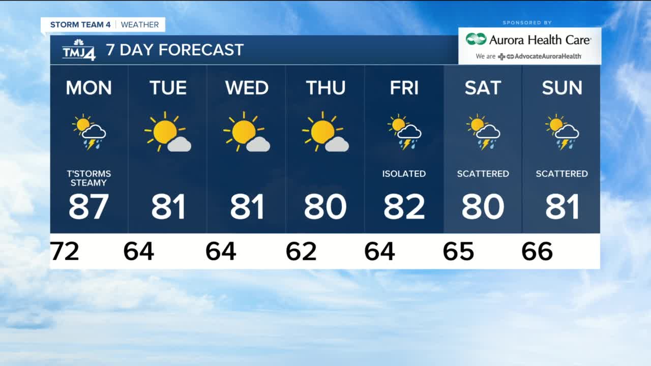
It was hot and humid again this afternoon and then a slow moving line of storms arrived at 4pm with a few severe warnings including Milwaukee and Waukesha. The main threat was wind gusts from 45 to 60 mph. There was a lot of lightning and blinding downpours. Scattered showers will continue this evening and taper off before 11pm. The rest of the night is humid with patchy fog and lows near 70. Monday stays very humid and hot with highs in the mid to upper 80s. Scattered t'storms fire up after 3pm ahead of a cold front. The rain will taper off in evening and then the humidity drops with the wind shifting to the northwest. Tuesday and Wednesday are gorgeous with dry air, lots of sun and highs near 80. The humidity increases a little on Thursday and Friday with highs near 80 and just an isolated pop up shower. The weekend is in the lower 80s, some humidity and scattered t'storms.
-
 1:42
1:42
WTMJMilwaukee
1 year agoToday's Talker: Joe Jonas files for divorce from Sophie Turner after four years of marriage
867 -
 2:56
2:56
KTNV
4 years agoAugust 22, 2020 evening weather forecast for Las Vegas.
11 -
 2:58
2:58
KJRH
4 years agoSunday morning weather forecast for Aug. 16
3 -
 2:15
2:15
KERO
4 years ago23ABC Weather for August 27, 2020
509 -
 2:42
2:42
KERO
4 years ago23ABC Weather for August 25, 2020
395 -
 2:22
2:22
KERO
4 years ago23ABC Weather for August 17, 2020
331 -
 1:34
1:34
KERO
4 years ago23ABC Evening weather update August 8, 2020
1.81K -
 1:54
1:54
KERO
4 years ago23ABC Evening weather update August 31, 2020
1.7K -
 1:32
1:32
KERO
4 years ago23ABC Evening weather update August 26, 2020
1.67K -
 2:03
2:03
KERO
4 years ago23ABC Evening weather update August 24, 2020
1.6K