NBC26 Storm Shield Forecast
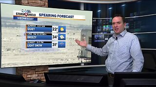
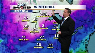
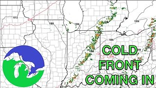
We get above freezing on Wednesday with low/mid-30s with clouds on the increase. Wednesday night, a strong cold front will move through. Along this front, and a system riding along it from the SE, 1-3" of snow look to fall with the lower totals to the northwest, and higher totals to the SE. It could carry over into the early half of Thursday morning, bringing another Tr.-1" That would bring event totals south of HWY 29 from 2-4" and north of there only 1-2". Temperatures will struggle to make it into the lower teens. Wind chills Thursday AM will be in the -10s/-20s!! It will be bitterly cold on Thursday night with lows well below zero. In fact....it could be the coldest night of the winter so far for most of us with lows in the -10s!! We will climb to around 10° on Friday with sunny skies. We're back into the 20s/30s for the weekend with a little more snow possible.
-
 2:12
2:12
WGBA
4 years agoNBC26 Storm Shield Forecast
9 -
 4:30
4:30
WGBA
4 years agoNBC26 Storm Shield Forecast
8 -
 9:45
9:45
Great Lakes Weather
9 months agoIsolated Severe Storms Possible Tomorrow, Cooler Weather Ahead -Great Lakes Weather
4 -
 2:16
2:16
Mohibbanchannels
4 months agoThundersnow Storm
251 -
 12:19
12:19
Great Lakes Weather
2 years agoMore Active Weather Ahead, Thunderstorms AND Snow in One Week -Great Lakes Weather
4 -
 1:34
1:34
AmericanNewsBullet
5 months agoBreaking News: Northeast USA Braces for Severe Winter Storm | Latest Updates
19 -
 0:14
0:14
Shelisa45
3 years ago $0.09 earnedSnow Storm Coming
577 -
 8:28
8:28
Lvfree Adventures
5 months agoWinter Storm 2024 Snow Storm Northeast Winter Storm Warning
-
 0:52
0:52
Reuters
2 years agoSnow, sleet and rain hit southeastern U.S.
2242 -
 1:03
1:03
JTN2020
1 year agoSatellite imagery captures powerful winter storm moving across US
14