Gino Recchia NBC26 Weather Forecast
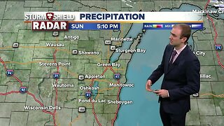
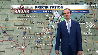
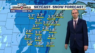
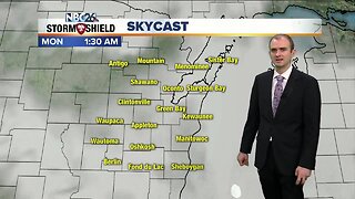
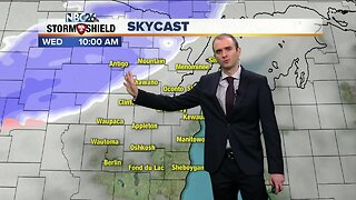
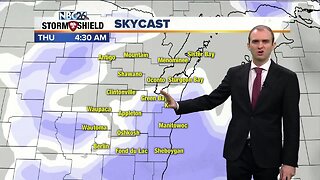
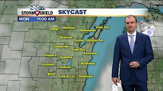
Get ready for our next snow storm. A strong clipper will bring in accumulations over a half foot for many areas by tomorrow evening. Winter weather advisories and winter storm warnings are in place because of this storm. First, this evening a few flurries will scatter around with temperatures falling into the mid and lower teens. We could have a small period over mostly clear skies before we cloud over rapidly heading into the morning. Winds will be light out of the southwest at 5 mph. The clipper will arrive during the morning. First it will start between 6-8 AM west of a Clintonville to Fond du Lac line. The rest of the area will see the flake fly between 8-10 AM expect Marinette, Menominee (MI), and Door County. A little after 10 am is when the snow will start falling for you folks. The intensity of the snow will produce rates between 1-2 inches per hour at times. It will begin to taper between 2-4 PM in Central Wisconsin. By around 5:30 PM, just a few light snow showers or flurries will remain. Totals will be on the lower end to the far north, 2-4 inches. Most will pick up 4-7 inches with 6-9 inches near and west of the Fox Valley. Skies will start to clear Sunday night with falling temperatures into the lower teens. It will be a sunny beginning to the work week. Temperatures will climb into the mid 20s.
-
 3:36
3:36
WGBA
7 months agoWill it be necessary to have both the AC & the heat on during the same day??
991 -
 3:20
3:20
WGBA
4 years agoGino Recchia NBC26 Weather Forecast
34 -
 3:26
3:26
WGBA
4 years agoGino Recchia NBC26 Weather Forecast
27 -
 2:48
2:48
WGBA
4 years agoGino Recchia NBC26 Weather Forecast
19 -
 2:53
2:53
WGBA
4 years agoGino Recchia NBC26 Weather Forecast
12 -
 3:23
3:23
WGBA
4 years agoGino Recchia NBC26 Weather Forecast
12 -
 2:55
2:55
WGBA
4 years agoGino Recchia NBC26 Weather Forecast
14 -
 2:53
2:53
WGBA
4 years agoGino Recchia NBC26 Weather Forecast
6 -
 2:48
2:48
WGBA
4 years agoGino Recchia NBC26 Weather Forecast
13 -
 1:03
1:03
WGBA
4 years agoGino Recchia NBC26 Weather Forecast
14