Michael Fish's NBC 26 weather forecast
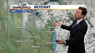
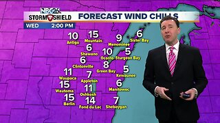
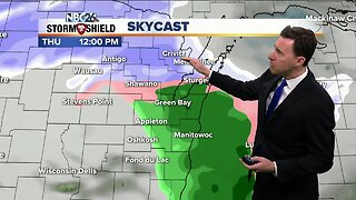
There is still a great deal of uncertainty for the snow for Saturday night. Some of the latest, reliable model data sets have this system weaker, and tracking farther southeast. More on this below. Today will be quiet with high temperatures climbing into the lower to mid 30s. Later tonight, a light round of snow will impact parts of the area with minimal accumulations of up to 1-2", but less NW. Temperatures will fall to around 20 by Saturday morning. There is still quite a bit of uncertainty with the snow over the weekend, but the main round would move through on Saturday night. The farther you live to the SE, the more snow you will see. Green Bay and the Fox Cities looks like the potential of a moderate snow of 3-6", towards Sheboygan, 6-10", and lesser amounts NW. If you move this storm NW, all of our totals are going to go up. If the trend of this going SE and weakening continues, we're going to have to lower these totals even further. There will be a lot of wind with this system though. The Tundra will be frozen at kickoff on Sunday, but it won't be that cold with temps in the lower to mid 20s. We're also watching the for the chance some snow as a couple of systems move across the Great Lakes next week.
-
 1:45
1:45
WGBA
1 year agoStudents excited to start at "huge and beautiful" Vel Phillips Middle School
210 -
 1:04
1:04
WGBA
4 years agoMichael Fish's NBC 26 weather forecast
21 -
 2:27
2:27
WGBA
4 years agoMichael Fish's NBC 26 weather forecast
5 -
 2:23
2:23
WGBA
4 years agoMichael Fish's NBC 26 weather forecast
9 -
 2:34
2:34
WGBA
4 years agoMichael Fish's NBC 26 weather forecast
15 -
 2:33
2:33
WGBA
4 years agoMichael Fish's NBC 26 weather forecast
13 -
 2:45
2:45
WGBA
4 years agoMichael Fish's NBC 26 weather forecast
9 -
 2:47
2:47
WGBA
4 years agoMichael Fish's NBC 26 weather forecast
11 -
 3:08
3:08
WGBA
4 years agoMichael Fish's NBC 26 weather forecast
52 -
 3:19
3:19
WGBA
4 years agoMichael Fish's NBC 26 weather forecast
29