Gino Recchia NBC26 Weather Forecast
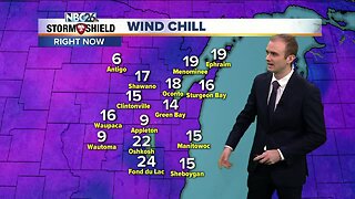
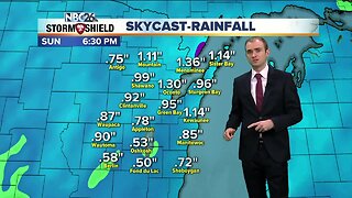
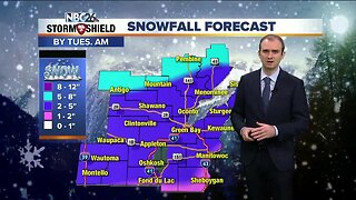
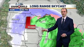
The wintry mix we have seen on and off today will be coming to an end later this evening. By the overnight, temperatures will fall into the upper 20s and lower 30s with winds intially out of the southwest at 5-10 mph turning west by daybreak. Friday remains under mostly cloudy skies with high temperatures climbing into the lower to mid 30s. Friday night, a light round of snow is possible with minimal accumulations under an inch. Temperatures will fall to around 20 by Saturday morning. A potential large snow storm may affect Northeast Wisconsin Saturday afternoon through early Sunday before sunrise. Snowfall totals over a half foot to near a foot is not out of the question. With temperatures falling into the teens Saturday night, this will be a light and fluffy snow allowing accumulations to be higher than if it was a wet and heavy snow. Either way you put it, you will more than likely need to get the snowblowers gassed up. The Tundra will be frozen at kickoff on Sunday, but it won't be that cold with temps in the lower to mid 20s. We're also watching the for the chance some snow as a couple of systems move across the Great Lakes next week.
-
 0:30
0:30
WGBA
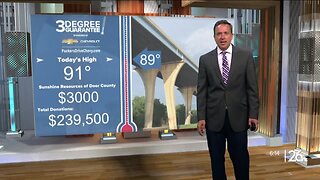
9 months agoThree Degree Guarantee
130 -
 2:52
2:52
WGBA
4 years agoGino Recchia NBC26 Weather Forecast
10 -
 3:53
3:53
WGBA
4 years agoGino Recchia NBC26 Weather Forecast
37 -
 3:45
3:45
WGBA
4 years agoGino Recchia NBC26 Weather Forecast
8 -
 5:11
5:11
WGBA
4 years agoGino Recchia NBC26 Weather Forecast
25 -
 4:00
4:00
WGBA
4 years agoGino Recchia NBC26 Weather Forecast
9 -
 4:33
4:33
WGBA
4 years agoGino Recchia NBC26 Weather Forecast
21 -
 3:53
3:53
WGBA
4 years agoGino Recchia NBC26 Weather Forecast
12 -
 3:14
3:14
WGBA
4 years agoGino Recchia NBC26 Weather Forecast
20 -
 3:14
3:14
WGBA
4 years agoGino Recchia NBC26 Weather Forecast
34