Gino Recchia NBC26 Weather Forecast
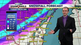
Winter weather advisories have been issued for counties northwest of the Fox Valley starting at midnight and continuing through 6 pm Monday evening. Clouds will increase tonight and a light drizzle/mist may develop overnight resulting in some slick spots on any untreated roadways. More steadier moisture will move in during the early morning hours. Temperatures will be warm enough to support rain south of a line from Wautoma through Sturgeon Bay. A wintry mix will occur along that line, and north of it, snowfall will be the primary focus. Eventually cold air will shuffle in and change any wintry mix to snow across all of Northeast Wisconsin. That round of snow will move in by the mid and late afternoon resulting in poor roadway conditions. A few lingering snow showers or flurries will carry over into the late evening but by Midnight, any left over snow will be out of our area. By the late morning, only a dusting to an inch will accumulate along and north of a line from Wautoma to Sturgeon Bay. Another 1-2 inches will fall in the late afternoon into the evening. Behind this storm system, a strong push or arctic air will drop temperatures into the teens on Tuesday. On Wednesday morning, we will wake up with temperatures below zero with afternoon highs between 4-8 degrees. If you are not ready for this yet, we quickly warm up into the lower 30s by the end of the week.
-
 4:19
4:19
WGBA
4 years agoGino Recchia NBC26 Weather Forecast
12 -
 4:17
4:17
WGBA
4 years agoGino Recchia NBC26 Weather Forecast
17 -
 15:40
15:40
Great Lakes Weather
10 months agoSupercell Sunday: Severe Weather Potential for Michigan and Indiana -Great Lakes Weather
14 -
 14:17
14:17
Great Lakes Weather
7 months agoStrong Thunderstorms Possible in Michigan Tomorrow; Snow In the Forecast -Great Lakes Weather
18 -
 12:19
12:19
Great Lakes Weather
2 years agoMore Active Weather Ahead, Thunderstorms AND Snow in One Week -Great Lakes Weather
4 -
 8:36
8:36
TiffanysContent
4 months agoDaily Weather Update: Snowstorm, Tornadoes, Thunderstorms, LIGHTNING, Heavy Rainfall, Black Ice, FOG
37 -
 12:30
12:30
Great Lakes Weather
10 months agoHEAT WAVE and SEVERE WEATHER expected this week -Great Lakes Weather
35 -
 9:13
9:13
TiffanysContent
4 months agoChicago Fog, Gulf Coast Flood, ThunderStorms, Freezing Rain, Snow, Atmospheric River
37 -
 6:46
6:46
The Siouxland StormTrack Weather Channel
1 year agoSioux City Weather Forecast
7.06K -
 2:03
2:03
AMV
3 months agoBlizzard Is Forecast to Bring ‘Life-Threatening’ Conditions to California
14