
NBC26 Storm Shield Forecast
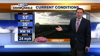
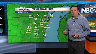
Today will not be as windy but will still be a cool day. Highs will top off in the upper 40s to mid 50s with a west wind around 5 to 15 mph with gusts near 25 mph. There is a weak disturbance that is going to move through later this afternoon and evening with rain showers. Right now areas south of Highway 29 have the risk of a few light rain showers. Winds will subside later tonight around 5 to 10 mph out of the west under partly cloudy to mostly cloudy skies and temperatures falling into the lower/mid 30s. Sun & clouds are expected on our Thursday with northwest winds around 5 to 10 mph. This is close to 10 degrees below our normal for this time of year. The coldest morning appears to be Friday with morning lows in the mid/upper 20s. Sunshine should warm us up into the mid/upper 40s. We get back into the 50s by the weekend. Skies will be mostly sunny. Much colder temperatures arrive next week. Halloween is going to be COLD!!
-
 1:45
1:45
WGBA
1 year agoFond du Lac Cardinals start the football season with a new $5.3 million nest
289 -
 3:55
3:55
WGBA
5 years agoNBC26 Storm Shield Forecast
2 -
 4:37
4:37
WGBA
5 years agoNBC26 Storm Shield Forecast
7 -
 3:45
3:45
WGBA
5 years agoNBC26 Storm Shield Forecast
14 -
 1:16
1:16
WGBA
5 years agoNBC26 Storm Shield Forecast
4 -
 3:53
3:53
WGBA
5 years agoNBC26 Storm Shield Forecast
17 -
 4:05
4:05
WGBA
5 years agoNBC26 Storm Shield Forecast
5 -
 2:00
2:00
WGBA
5 years agoNBC26 Storm Shield Forecast
17 -
 1:04
1:04
WGBA
5 years agoNBC26 Storm Shield Forecast
-
 3:26
3:26
WGBA
5 years agoNBC26 Storm Shield Forecast