
NBC26 Storm Shield Forecast
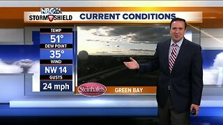
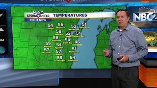
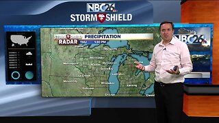
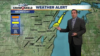
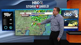
After a beautiful Sunday, say goodbye to the combination of sunshine and 60 degree weather because we have showers and storms today. Temperatures will climb into the upper 50s to near 60 degrees but it will be a bit of a raw day as winds will pick up out of the southeast around 15 to 25 mph with gusts near 30 mph. This has prompted the National Weather Service to issue a lakeshore flood advisory for all counties along Lake Michigan. Showers and storms will arrive here by the mid-morning hours and persist through the afternoon. Coverage will diminish later this evening but a periodic risk of showers will remain overnight. Rainfall totals will likely be in the range of a third of an inch to around an inch. Temperatures will fall into the lower 40s. Breezy winds continue Tuesday as the center of low pressure tracks through Wisconsin. High temperatures will be in the mid and upper 40s with a steady southeast wind around 15 to 25 mph with gusts near 35 mph. Scattered showers will also take place during the day. It turns more quiet for our Wednesday as this storm system moves out, leaving us with mostly cloudy to partly cloudy skies and highs in the upper 40s.
-
 0:30
0:30
WGBA
1 year agoThree Degree Guarantee
234 -
 3:55
3:55
WGBA
5 years agoNBC26 Storm Shield Forecast
2 -
 3:53
3:53
WGBA
5 years agoNBC26 Storm Shield Forecast
17 -
 1:04
1:04
WGBA
5 years agoNBC26 Storm Shield Forecast
-
 3:26
3:26
WGBA
5 years agoNBC26 Storm Shield Forecast
-
 1:15
1:15
WGBA
5 years agoNBC26 Storm Shield Forecast
8 -
 3:41
3:41
WGBA
5 years agoNBC26 Storm Shield Forecast
1 -
 3:41
3:41
WGBA
5 years agoNBC26 Storm Shield Forecast
1 -
 1:21
1:21
WGBA
5 years agoNBC26 Storm Shield Forecast
10 -
 4:51
4:51
WGBA
5 years agoNBC26 Storm Shield Forecast
6