
Gino Recchia NBC26 Weather Forecast
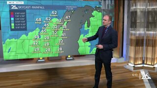
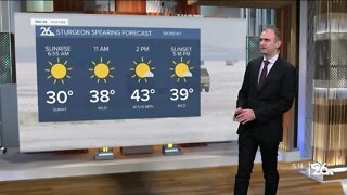
Temperatures remained a few degrees above freezing for most of Northeast Wisconsin this morning however, it was still the coldest since May 12th, exactly 5 months ago. A wintry mix is possible this evening as the powerful low pressure remains stalled across the Midwest. Winds will be breeze out of the southwest around 10 to 15 mph with temperatures falling into the mid 30s. Sunday, high temperatures will be in the lower 40s with west winds at 10 to 20 mph with gusts near 25 mph. Ths will keep wind chill values down into the 30s. There will be an additional potential for a wintry mix. Dry weather returns Monday. Highs reach into the upper 40s with partly cloudy skies. Temperatures by the Packers kickoff will likely be around the lower 40s. Tuesday, a round of rain will move in with high temperatures in the mid 50s. Lower to mid 50s can be expected for your Wednesday and Thursday. We get back to around 60 degrees by Friday. It appears dry during the day but then later at night, some rain showers will pass through.
-
 3:36
3:36
WGBA
1 year agoWill it be necessary to have both the AC & the heat on during the same day??
2901 -
 3:11
3:11
WGBA
1 year agoGino Recchia NBC26 Weather Forecast
1 -
 2:57
2:57
WGBA
1 year agoGino Recchia NBC26 Weather Forecast
-
 3:52
3:52
WGBA
1 year agoGino Recchia NBC26 Weather Forecast
-
 4:06
4:06
WGBA
1 year agoGino Recchia NBC26 Weather Forecast
13 -
 4:42
4:42
WGBA
1 year agoGino Recchia NBC26 Weather Forecast
10 -
 3:51
3:51
WGBA
1 year agoGino Recchia NBC26 Weather Forecast
24 -
 2:38
2:38
WGBA
1 year agoGino Recchia NBC26 Weather Forecast
2 -
 3:45
3:45
WGBA
1 year agoGino Recchia NBC26 Weather Forecast
4 -
 3:54
3:54
WGBA
1 year agoGino Recchia NBC26 Weather Forecast