
Gino Recchia NBC26 Weather Forecast
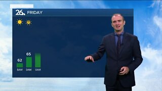
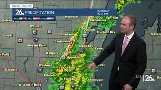
After a sunshine filled Thursday, our Friday is quite different. A low pressure system traveled from the Central Plains and now is providing us with showers and thunderstorms. The risk of showers and storms will continue through the majority of the day until a cold front move through later in the evening. High temperatures will get into the mid 60s with a steady south breezy between 10 and 20 mph with gusts near 25-30. A few showers will linger tonight but by midnight, all the rain should be moved out. Overnight lows will be in the upper 40s to near 50 degrees with a wind shift out of the northwest between 5 and 15 mph. Skies will turn partly cloudy gradually. Saturday will be cool but sunny with highs in the lower 60s. Winds will remain out of the northeast around 5 to 10 mph. The clouds build in on Saturday night and we will have a few isolated showers. Overnight lows will be near 50 degrees. Sunday, showers and thunderstorms will move throughout the day, highs will be in the lower to mid 60s.
-
 1:45
1:45
WGBA
1 year agoStudents excited to start at "huge and beautiful" Vel Phillips Middle School
364 -
 3:21
3:21
WGBA
2 years agoGino Recchia NBC26 Weather Forecast
9 -
 3:35
3:35
WGBA
2 years agoGino Recchia NBC26 Weather Forecast
-
 4:12
4:12
WGBA
2 years agoGino Recchia NBC26 Weather Forecast
-
 3:13
3:13
WGBA
2 years agoGino Recchia NBC26 Weather Forecast
1 -
 3:42
3:42
WGBA
2 years agoGino Recchia NBC26 Weather Forecast
2 -
 3:39
3:39
WGBA
2 years agoGino Recchia NBC26 Weather Forecast
1 -
 2:24
2:24
WGBA
2 years agoGino Recchia NBC26 Weather Forecast
1 -
 3:27
3:27
WGBA
2 years agoGino Recchia NBC26 Weather Forecast
14 -
 2:37
2:37
WGBA
2 years agoGino Recchia NBC26 Weather Forecast
4