Gino Recchia NBC26 Weather Forecast
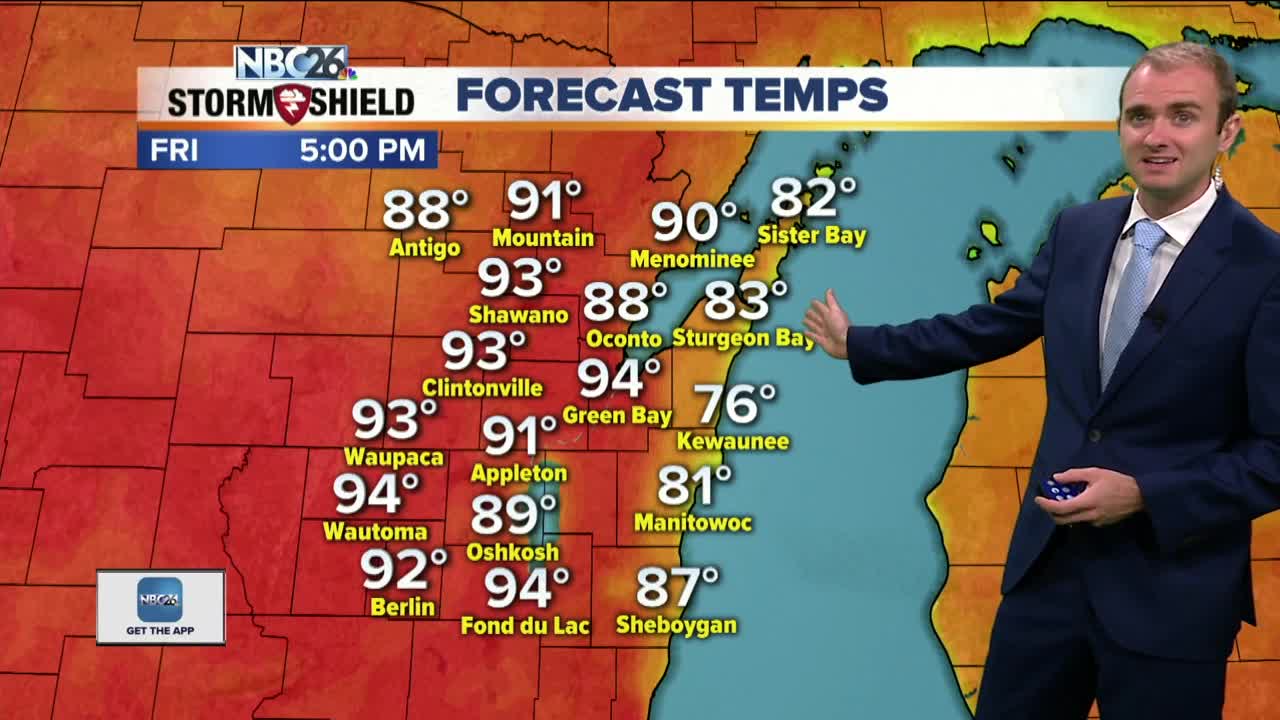
We have heat advisories and excessive heat warnings for most of the NBC26 viewing area today. We started off the morning with some showers and thunderstorms moving through. These will quickly exit by the late morning. The hottest day of this latest heat wave is today, High temperatures will rise into the lower to mid 90s and then when you couple that with the high humidity levels, it will feel well into the 100s. Keep in mind that the heat index is what it feels like outside in the shade. If you are under the sun, expect the heat index to be as much as 15 degrees hotter. Tonight our attention turns to the potential for severe weather moving in from Northwest Wisconsin. This has the capability of hail, damaging winds, and a small tornado threat. The severe storms are all dependent on if these storms do fire up to our west. Things can change from now and then so continue to follow us for more update. A cold front is going to move in on Saturday bringing more thunderstorms to the area but more importantly, giving us some relief from the heat and humidity. High temperatures on Saturday will be in the mid 80s. Temperatures will fall into the upper 70s and lower 80s from Sunday through early next week. There is a small chance of storms return on Wednesday and Thursday.
-
 1:45
1:45
WGBA
1 year agoFond du Lac Cardinals start the football season with a new $5.3 million nest
387 -
 3:02
3:02
WGBA
3 years agoGino Recchia NBC26 Weather Forecast
6 -
 4:09
4:09
WGBA
3 years agoGino Recchia NBC26 Weather Forecast
2 -
 3:43
3:43
WGBA
3 years agoGino Recchia NBC26 Weather Forecast
23 -
 3:20
3:20
WGBA
3 years agoGino Recchia NBC26 Weather Forecast
11 -
 2:48
2:48
WGBA
3 years agoGino Recchia NBC26 Weather Forecast
1 -
 3:21
3:21
WGBA
3 years agoGino Recchia NBC26 Weather Forecast
2 -
 3:25
3:25
WGBA
3 years agoGino Recchia NBC26 Weather Forecast
4 -
 3:20
3:20
WGBA
3 years agoGino Recchia NBC26 Weather Forecast
12 -
 3:55
3:55
WGBA
3 years agoGino Recchia NBC26 Weather Forecast
145