Michael Fish's NBC26 weather forecast
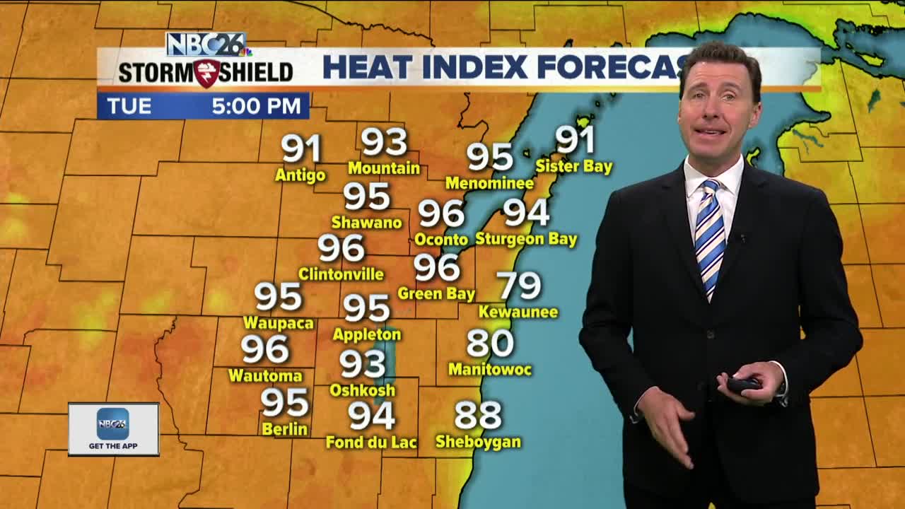
We have another very warm and humid day on tap, with only a slight chance of a stray afternoon T'storm. Highs will be in the upper-80s to near 90 in a few spots which will kick those heat indices well into the 90s. The chance of a few scattered T'storms will continue tonight, but not everyone would see that activity. These could bring a few locally heavy downpours they do develop. We do have a very weak cool front moving through that will shift the wind to the E. Lows will be in the upper-60s. Wednesday will be another warm and muggy one, though there should be some relief near Lake Michigan with winds out of the east. Chances of scattered T'storms will increase in the mid- to late-afternoon and we'll have warm, humid highs in the mid- to upper-80s. Again, it will be cooler lakeside. Any of these T'storms could produce locally heavy downpours. The chances of storms ramp up even more late Wednesday night with what looks like a line of T'storms that should be passing through. This could bring locally heavy rain and gusty wind. Get ready for a scorcher with lots of humidity both Thursday, Friday with highs in the low-90s. Heat indices in many locations will probably exceed 100°. Saturday will be very warm and humid again with a slight chance of a T'storm. We could see a better shot at T'storms Sunday with a cold front on the way. It looks like we get a cool down from the heat late by early next week.
-
 1:45
1:45
WGBA
1 year agoStudents excited to start at "huge and beautiful" Vel Phillips Middle School
387 -
 4:08
4:08
WGBA
3 years agoBrittney's NBC26 Weather Forecast
1 -
 3:02
3:02
WGBA
3 years agoGino Recchia NBC26 Weather Forecast
6 -
 4:09
4:09
WGBA
3 years agoGino Recchia NBC26 Weather Forecast
2 -
 3:43
3:43
WGBA
3 years agoGino Recchia NBC26 Weather Forecast
23 -
 3:21
3:21
WGBA
3 years agoGino Recchia NBC26 Weather Forecast
2 -
 3:20
3:20
WGBA
3 years agoGino Recchia NBC26 Weather Forecast
11 -
 3:55
3:55
WGBA
3 years agoGino Recchia NBC26 Weather Forecast
145 -
 2:48
2:48
WGBA
3 years agoGino Recchia NBC26 Weather Forecast
1 -
 3:25
3:25
WGBA
3 years agoGino Recchia NBC26 Weather Forecast
4