NBC26 Storm Shield weather forecast
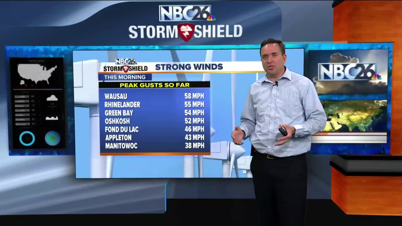
After some very gusty winds behind last night's batch of rain, it will still be windy today, but not as windy as it was early this morning. We may break into a little sunshine by the afternoon, but if this happens, we could touch off a shower or T'storm. Temps will warm into the 60s & 70s......with the warmest weather SW of Lake Winnebago. Gusty SE winds will keep it much cooler near the Lake with areas of fog there. We will continue that slight chance of a T'storm into the evening, but most of that should be gone if there's anything by later tonight. Lows will be in the 40s. Thursday looks milder & mostly sunny with high near 70°. Showers & storms return on Friday along with highs only in the 50s and 60s depending on where the stationary front sets up. Right now, the Holiday Weekend mostly looks mostly dry & warm with a small chance of rain on Monday.
-
 1:57
1:57
WGBA
1 year agoHow the City of Green Bay is hoping a $1.6M investment will make the community safer for pedestrians
3932 -
 3:20
3:20
WGBA
3 years agoGino Recchia NBC26 Weather Forecast
11 -
 3:27
3:27
WGBA
3 years agoGino Recchia NBC26 Weather Forecast
2 -
 3:54
3:54
WGBA
3 years agoGino Recchia NBC26 Weather Forecast
5 -
 3:06
3:06
WGBA
3 years agoGino Recchia NBC26 Weather Forecast
1 -
 3:43
3:43
WGBA
3 years agoGino Recchia NBC26 Weather Forecast
3 -
 3:18
3:18
WGBA
3 years agoGino Recchia NBC26 Weather Forecast
7 -
 3:00
3:00
WGBA
3 years agoGino Recchia NBC26 Weather Forecast
4 -
 3:57
3:57
WGBA
3 years agoGino Recchia NBC26 Weather Forecast
5 -
 3:52
3:52
WGBA
3 years agoGino Recchia NBC26 Weather Forecast
10