
NBC26 Storm Shield weather forecast
5 years ago
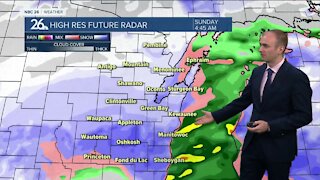
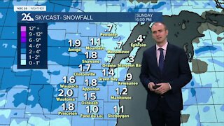
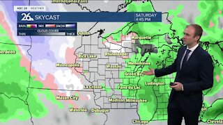
An area of low pressure will head towards the state tonight which will bring some showers/rain & maybe an isolated storm. Lows will be in the upper-40s with gusty easterly winds. A lingering shower/storm is possible Wednesday morning before we break into a little sunshine by the afternoon. Temps will warm into the 60s & 70s......with the warmest weather SW of Lake Winnebago. Gusty SE winds will keep it much cooler near the Lake with areas of fog. Thursday looks milder & mostly sunny with high near 70°. Showers & storms return on Friday along with highs only in the 50s. Right now, the Holiday Weekend mostly looks dry & warm with a small chance of rain on Monday.
Loading comments...
-
 1:45
1:45
WGBA
1 year agoFond du Lac Cardinals start the football season with a new $5.3 million nest
268 -
 3:20
3:20
WGBA
3 years agoGino Recchia NBC26 Weather Forecast
11 -
 3:27
3:27
WGBA
3 years agoGino Recchia NBC26 Weather Forecast
2 -
 3:54
3:54
WGBA
3 years agoGino Recchia NBC26 Weather Forecast
5 -
 3:06
3:06
WGBA
3 years agoGino Recchia NBC26 Weather Forecast
1 -
 3:18
3:18
WGBA
3 years agoGino Recchia NBC26 Weather Forecast
7 -
 3:00
3:00
WGBA
3 years agoGino Recchia NBC26 Weather Forecast
4 -
 3:57
3:57
WGBA
3 years agoGino Recchia NBC26 Weather Forecast
5 -
 3:52
3:52
WGBA
3 years agoGino Recchia NBC26 Weather Forecast
10 -
 3:33
3:33
WGBA
3 years agoGino Recchia NBC26 Weather Forecast
3