
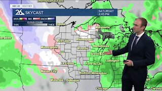
Michael Fish's NBC26 weather forecast
Most of today looks dry, but a little cooler with highs only in the upper-50s to low-60s, though cooler lakeside thanks to gusty NE winds. There will be a slight chance of a shower, mainly southwest of the Fox Cities. Most of the shower activity starts to arrive as we head later into the night, tonight. Lows will be in the mid-40s. Rain will be rolling through at times during the weekend and to cap it off, it's going to be cool and windy. As of right now, Saturday will have some showers or possibly a T'storm, but it shouldn't be a total wash. Sunday may be the rainier of the two weekend days. Depending on where the frontal boundary sets up over the weekend......highs will range form the 40s/50s/60s to the 70s/80s farther south in Wisconsin. As of right now, it looks like Northeast Wisconsin will probably stay on the cooler side of this, but with the warm air close, we still may have a T'storm embedded with the rain. Over the next 3-5 days the rain totals will start to add up with many spots seeing 1.5-3" of rain.
-
 3:36
3:36
WGBA
1 year agoWill it be necessary to have both the AC & the heat on during the same day??
3431 -
 3:20
3:20
WGBA
3 years agoGino Recchia NBC26 Weather Forecast
11 -
 3:06
3:06
WGBA
3 years agoGino Recchia NBC26 Weather Forecast
1 -
 2:33
2:33
WGBA
4 years agoMichael Fish's NBC 26 weather forecast
4 -
 3:18
3:18
WGBA
3 years agoGino Recchia NBC26 Weather Forecast
7 -
 3:00
3:00
WGBA
3 years agoGino Recchia NBC26 Weather Forecast
4 -
 2:19
2:19
WGBA
4 years agoMichael Fish's NBC 26 weather forecast
3 -
 2:26
2:26
WGBA
4 years agoMichael Fish's NBC 26 weather forecast
4 -
 2:24
2:24
WGBA
4 years agoMichael Fish's NBC 26 weather forecast
3 -
 1:57
1:57
WGBA
4 years agoMichael Fish's NBC 26 weather forecast
2