NBC26 Storm Shield weather forecast
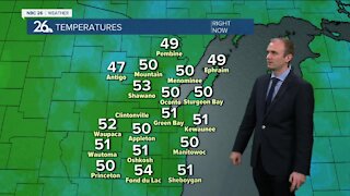
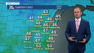
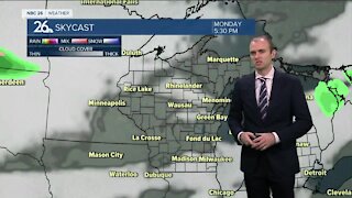
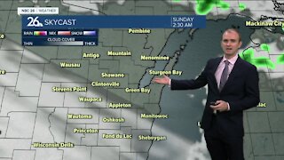
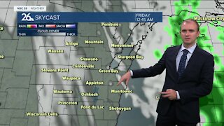
High pressure will control our weather for one more day. Quiet, dry conditions will continue tonight with lows in the upper-30s and low-40s under mostly clear skies. Clouds slowly increase in the afternoon Tuesday ahead of the next system on the way. Who really cares though with highs around 70, though cooler readings will be possible near Lake Michigan. We'll have a weak frontal boundary pass through on Tuesday night. This could touch off a few scattered showers or a T'storm. Lows will be mild around 50. Wednesday looks dry with highs in the upper-60s as winds turn back to the NE. The risk of rainfall sticks around through most of the rest of the work week and into the weekend making it potentially another wet period for Northeast Wisconsin. Just what we don't need.
-
 0:30
0:30
WGBA
7 months agoThree Degree Guarantee
59 -
 3:20
3:20
WGBA
2 years agoGino Recchia NBC26 Weather Forecast
11 -
 3:18
3:18
WGBA
2 years agoGino Recchia NBC26 Weather Forecast
7 -
 3:00
3:00
WGBA
2 years agoGino Recchia NBC26 Weather Forecast
4 -
 3:33
3:33
WGBA
2 years agoGino Recchia NBC26 Weather Forecast
2 -
 2:38
2:38
WGBA
2 years agoGino Recchia NBC26 Weather Forecast
3 -
 3:13
3:13
WGBA
2 years agoGino Recchia NBC26 Weather Forecast
1 -
 3:54
3:54
WGBA
2 years agoGino Recchia NBC26 Weather Forecast
61 -
 4:05
4:05
WGBA
2 years agoGino Recchia NBC26 Weather Forecast
1 -
 4:11
4:11
WGBA
2 years agoGino Recchia NBC26 Weather Forecast
3